What is subsurface imaging?
Why it matters:
-
It helps operators reduce drilling risk by better understanding geology before committing capital.
-
It improves reservoir characterization and field development planning.
-
It supports CCS site selection, monitoring and containment assessment.
-
It helps offshore wind developers identify shallow geohazards before construction.
Editor’s note: Welcome to Offshore’s new educational “What Is…?” series. If you’re interested in contributing your insights and sharing industry knowledge with the next generation of offshore professionals, contact Chief Editor Ariana Hurtado at [email protected] for more information.
By Igor Marino, TGS
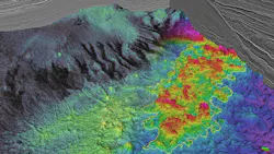
Subsurface imaging is the process of creating representations of the Earth's interior from geophysical measurements collected at the surface, on the seafloor or in the subsurface.
Geoscientists use a range of geophysical methods to investigate what lies beneath the Earth's surface, including seismic, electromagnetic, gravity and magnetic techniques.
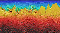
In offshore energy, however, seismic imaging is one of the principal methods for resolving geological structures at depth. These images help geoscientists identify reservoirs, understand complex geology, evaluate development opportunities and reduce uncertainty throughout energy projects.
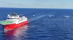
Following the previous "What is seismic data acquisition?" explainer article, this piece explores how the acquired seismic measurements are transformed into subsurface images that support exploration, field development, carbon storage and offshore wind projects.
Seeing beneath the seafloor
Direct observations of the subsurface are limited to locations where wells have been drilled or material has been exposed. To understand what lies between these control points, geoscientists use seismic waves, recorded during seismic surveys, to reveal the structure of rock layers thousands of meters below the surface.
However, the recorded data do not resemble an image. They consist of millions of measurements that must be processed and reconstructed at their correct subsurface location before geological interpretation is possible.
Subsurface imaging encompasses the technologies and workflows that perform this transformation. Its objective remains straightforward: to create a reliable representation of the subsurface. Achieving this goal requires sophisticated physics, high-performance computing and an understanding of seismic wave propagation through complex geology.
Why image quality matters
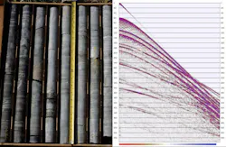
Much of the value derived from a seismic survey depends on the quality and suitability of the resulting image.
A clear image can:
- Improve confidence in exploration prospects;
- Better define reservoir boundaries;
- Reduce drilling risk; and
- Reveal faults, channels, stratigraphic features and other geological elements that influence project decisions.
Uncertainty in the image can lead to uncertainty in those decisions.
As offshore projects move into more complex settings, acquisition design and imaging objectives are increasingly considered together. Therefore, the industry has invested heavily in technologies and workflows designed to improve resolution and geological fidelity.
Building an image of the subsurface
Signal processing: Organizes and improves raw seismic recordings.
Velocity model building: Estimates how seismic waves travel through different rocks.
Migration: Places reflected seismic energy in its correct subsurface position.
Velocity model building is a critical component of the workflow. Because seismic waves travel at different speeds through different materials, geophysicists develop models that describe how velocity varies throughout the subsurface. Model quality plays an important role in determining how accurately geological features are positioned in depth. Imaging algorithms then use the model and recorded data to reconstruct wave propagation and position seismic energy within the subsurface.
Depending on project objectives, seismic images may initially be generated in time, which reflects the travel time of seismic waves, or in depth, which represents the estimated physical position of geological features. Because drilling and development decisions ultimately occur in depth, considerable effort is devoted to building accurate Earth models that support reliable depth imaging.

Modern imaging technologies
Subsurface imaging has advanced significantly, driven by improvements in computing power, Earth modeling and imaging algorithms.
One widely deployed migration method is reverse time migration (RTM), which uses the wave equation to reconstruct seismic wave propagation through complex geological environments. RTM is particularly valuable in areas with steeply dipping structures, complex fault networks and salt-related challenges.
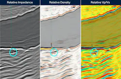
Another important development is full waveform inversion (FWI). Rather than relying on a limited set of information from the seismic signal, FWI uses a broader portion of the recorded wavefield to iteratively refine models of subsurface properties. These models can improve subsequent migration, while newer FWI-derived approaches can also yield high-resolution seismic images and subsurface parameters more directly.
Together, these technologies are helping geoscientists produce more detailed images in areas that were once considered extremely challenging to interpret.
Artificial intelligence and machine learning
Artificial intelligence (AI) and machine learning (ML) are increasingly being applied across the seismic imaging workflow.
Unlike imaging algorithms, such as RTM or FWI, which are grounded in the physics of wave propagation, AI tools are typically used to:
- Enhance efficiency;
- Automate repetitive tasks, and
- Analyze and help extract additional value from large datasets.
Applications range from noise attenuation and quality control to velocity model building and interpretation support. AI can help identify patterns that might be difficult to recognize manually, accelerate computationally intensive workflows and assist geoscientists in analyzing increasingly large and complex seismic surveys.
While AI is unlikely to replace physics-based imaging methods and human expertise, it is becoming a valuable complement to them. As computing capabilities continue to advance, the combination of physics-driven imaging and data-driven AI workflows is expected to play an increasingly important role in delivering reliable subsurface images and supporting faster decision-making.
One challenge, many solutions
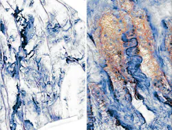
No two geological settings are identical, and imaging workflows must be adapted to geological targets and available data.
Some projects require regional imaging to understand basin-scale geology. Others focus on subtle reservoir features that demand higher resolution. Areas affected by salt bodies, volcanic rocks or complex overburden may require specialized workflows tailored to the specific imaging challenge.
As a result, modern subsurface imaging combines multiple technologies across survey design, data conditioning, velocity model building, migration and inversion. The most effective combination depends on the geology, data acquisition geometry, data characteristics and the decisions the image is intended to support.
Increasingly, survey design and imaging are considered together from the outset, helping ensure the recorded data are suited to the geological objectives of the project.
Where is subsurface imaging used offshore?
- Deepwater exploration (US Gulf, Brazil, Namibia)
- Mature field redevelopment (North Sea)
- CCS storage monitoring (Northern Lights, Gulf Coast projects)
- Offshore wind site characterization
Beyond oil and gas
While seismic imaging has long been associated with hydrocarbon exploration, its applications continue to expand. In producing fields, repeated surveys can track reservoir changes through time and support production optimization.
For carbon capture and storage (CCS) projects, subsurface imaging helps characterize storage reservoirs, evaluate containment risks and monitor changes associated with injected CO2.
In offshore wind developments, high-resolution imaging supports site characterization and helps identify shallow geohazards that could affect foundation design.
The same imaging technologies that have traditionally supported hydrocarbon exploration are increasingly being adapted for emerging energy applications, demonstrating the broader value of subsurface knowledge throughout the energy sector. Across these applications, the goal remains the same: reducing uncertainty through better subsurface understanding.
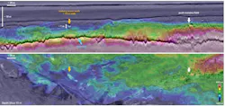
Looking deeper
Subsurface imaging is the bridge between data acquisition and geological understanding. By transforming seismic waves into meaningful representations of the Earth, imaging technologies support more informed decisions across the offshore energy sector.
As computing power, Earth modeling and imaging algorithms continue to evolve, the industry is gaining the ability to resolve geology with greater detail and confidence. The result is a clearer understanding of the subsurface and, ultimately, better-informed decisions above it.
Glossary:
| Term | Definition |
|---|---|
| Seismic imaging | Creating pictures of the Earth's subsurface from seismic data |
| RTM | Advanced migration method for complex geology |
| FWI | Technique that refines subsurface property models |
| Velocity model | Representation of seismic wave speeds underground |
| Migration | Process of positioning reflected seismic energy correctly |
Related content:
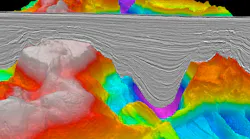 subsurface interpretation
 Female geoscientist examines print outs of seismic
Offshore's "What Is...?" series
Young professionals in the offshore energy industry often encounter technical terms and acronyms that seasoned subject matter experts (SMEs) know by heart—but aren’t always clear to the next generation. Offshore’s new “What Is…?” educational series aims to bridge that gap by providing concise, practical explainers for emerging professionals and newcomers to the industry.
Some of the topics we've already covered include:
- What is an FPSO?
- What is a dynamic positioning (DP) system?
- What is an SOV?
- What is directional drilling?
- What is CCS?
- What is floating wind?
- What is an offshore substation (OSS)?
- What is a digital twin?
- What is the deepwater oil and gas field development life-cycle?
- What is subsea electrification?
- What is a mooring system?
- What is offshore vessel water and waste management?
- What is an FSRU?
If there’s an offshore energy subject you’d like to highlight in a brief explainer article (600-1,000 words), reach out to Chief Editor Ariana Hurtado at [email protected] for more information.
About the Author
 Igor Marino
Igor Marino is technical marketing manager at TGS, where he leverages his 15+ years of geophysical experience to translate complex subsurface concepts into clear, relevant messages that resonate with both technical and commercial audiences. Based in Houston, he brings deep expertise in seismic acquisition, imaging workflows, full-waveform inversion and machine-learning applications in geosciences. He regularly shares insights on how integrated acquisition and imaging solutions enhance subsurface understanding. His work bridges technical depth with market relevance, contributing perspectives that help translate complex geoscience into practical exploration decisions.
You May Also Like
