What is seismic data acquisition?
Key takeaways:
- Seismic acquisition involves generating controlled sound waves and recording their reflections to image subsurface geological layers.
- Different survey types, including 2D, 3D and 4D, serve various exploration objectives, with 3D and 4D providing detailed structural and reservoir change insights.
- Modern offshore methods utilize towed streamers and ocean-bottom nodes, while land surveys employ vibratory sources and geophones for comprehensive data collection.
- Advances in sensor technology, survey design and data processing techniques, like RTM and FWI, significantly improve image resolution and depth penetration.
Editor’s note: Welcome to Offshore’s new educational “What Is…?” series. If you’re interested in contributing your insights and sharing industry knowledge with the next generation of offshore professionals, contact Chief Editor Ariana Hurtado at [email protected] for more information.
By Igor Marino, TGS
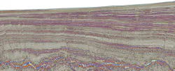
Seismic data acquisition is the process of collecting geophysical measurements that allow geoscientists to image the Earth’s subsurface. In offshore environments, it involves generating controlled sound waves and recording how those waves reflect from geological layers beneath the seafloor.
Although the principle is straightforward, modern seismic acquisition combines efficient operational logistics, advanced sensor technology and precise survey design to deliver increasingly detailed subsurface images.
Basic principle behind seismic acquisition
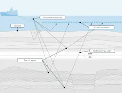
Seismic acquisition works by generating controlled acoustic energy and recording how that energy reflects from subsurface geological layers. In offshore environments, this is achieved using a range of acquisition configurations, including towed cables and ocean-bottom recording systems. While the equipment and deployment methods differ, the underlying principle remains the same.
An energy source releases a sound wave that travels through the water column and into the subsurface. As the wave encounters boundaries between different rock types, part of the energy is reflected toward the surface or seafloor, where it is recorded by receivers. These receivers may be towed behind a vessel, placed on the seafloor or deployed as seabed cables, depending on the survey design. They measure arrival times, amplitude and phase of the returning signals.
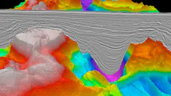
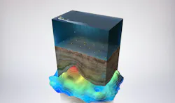
By combining measurements from many source and receiver positions, geophysicists can reconstruct a detailed image of the subsurface. Using known or data-derived velocity models, the recorded travel times are converted into depth and structure, revealing faults, stratigraphy and potential hydrocarbon systems.
Types of seismic surveys
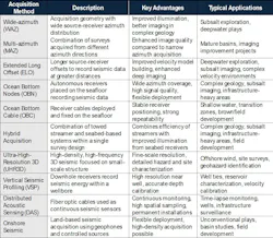
Different acquisition methods are used depending on exploration objectives and geological complexity. This section explores seismic survey definitions based on the type of data collected. Additional definitions are provided in the subsequent table below, organized by survey geometry and hardware utilized.
2D seismic
2D seismic surveys collect data along individual lines, producing cross-sectional views of the subsurface. These surveys are often used in frontier regions where companies need regional geological context before committing to more detailed studies.
Because they can cover large areas efficiently, 2D surveys are commonly used during early basin screening and licensing rounds.
3D seismic
3D seismic surveys collect data over an area using a well-defined distribution of sources and receivers. Data may be acquired using towed streamer configurations, ocean-bottom nodes (OBNs), ocean-bottom cable systems, or combinations of these methods, depending on the environment and survey objectives. Each approach is designed to provide sufficient spatial coverage and signal quality to accurately image geological structures.
The resulting datasets offer significantly improved structural clarity and stratigraphic detail compared to 2D.
3D seismic surveys have become the standard for exploration, field development and reservoir characterization across most offshore basins.
4D seismic
4D seismic refers to the repeated acquisition of 3D seismic surveys over the same area at different points in time. By comparing these datasets, geoscientists can identify differences in seismic response caused by changes in the reservoir, such as variations in fluid saturation and pressure. These surveys can be acquired using both towed streamer and seabed-based methods, with a strong emphasis on repeatability to ensure consistent results.
As a result, 4D seismic has become a valuable tool for reservoir management, helping operators optimize production, plan infill wells and improve recovery over the life of a field.
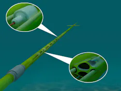
Towed streamer acquisition
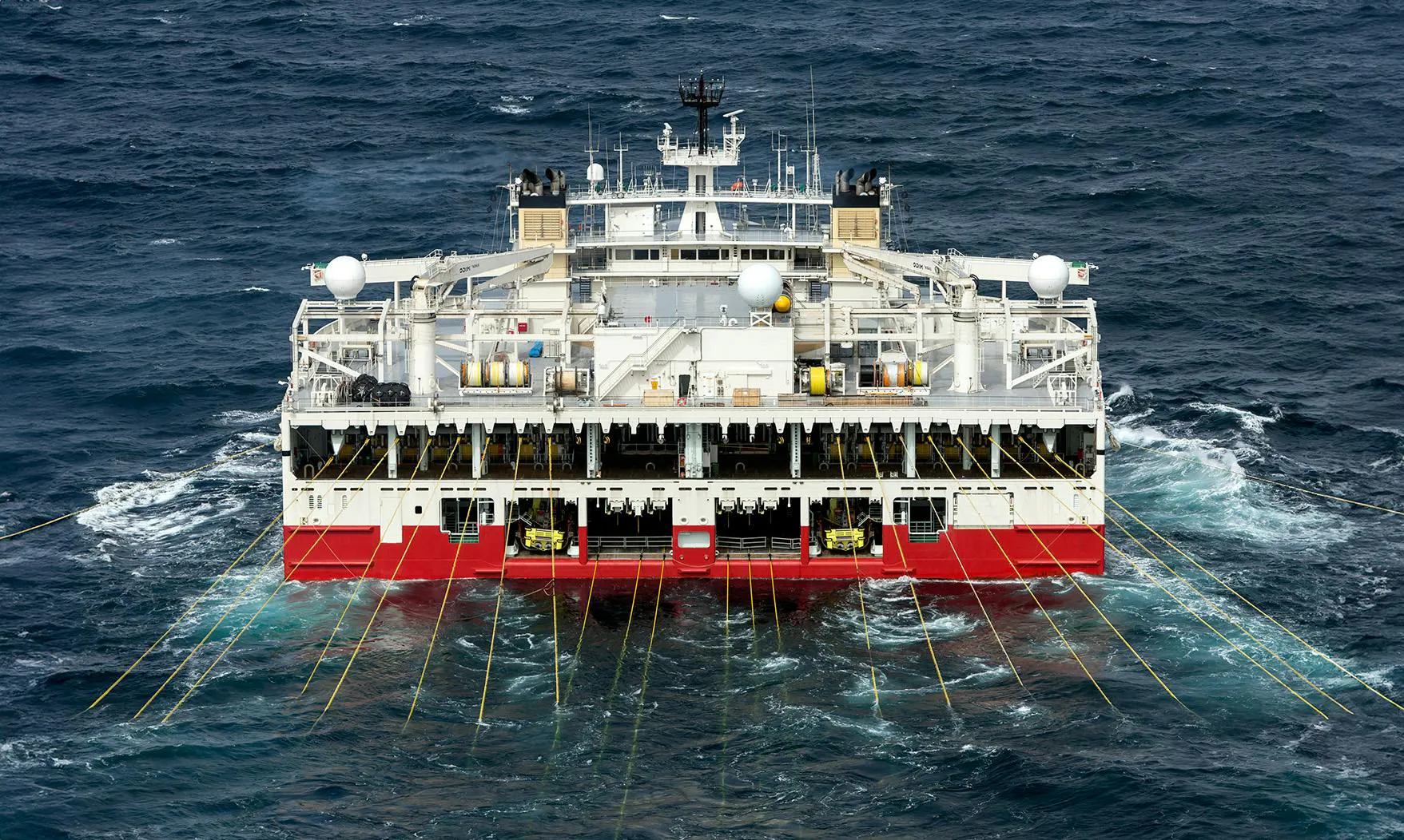
Offshore seismic acquisition relies on specialized vessels and advanced sensor systems. Modern seismic vessels tow large spreads of streamers that can extend several kilometers behind the ship. Some high-capacity vessels are designed specifically for large-scale surveys, capable of towing wide streamer arrays that maximize coverage and operational efficiency.
Technologies such as multisensor streamers have significantly improved signal quality. By recording both pressure and particle velocity, these systems yield a higher signal-to-noise ratio and capture broader frequency bandwidths, producing more detailed images of the subsurface. Advances in survey design have also enabled specialized acquisition approaches.
Ultra-high-resolution 3D (UHR3D) surveys, designed to capture fine-scale geological features through higher frequency content and denser spatial sampling, are increasingly used in shallow-water environments to image geohazards that may affect offshore infrastructure.
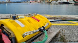
Ocean-bottom node systems
Ocean-bottom nodes (OBNs) are sensors placed directly on the seafloor that record seismic waves from fixed positions. Because the receivers remain stationary and closer to the subsurface, OBN surveys can capture high-quality data even in areas with heavy platform infrastructure. They also provide full azimuthal coverage potential, improving illumination in complex geological settings such as subsalt.
Recent developments in node-based acquisition systems and survey management technologies have improved deployment efficiency and data quality. These approaches complement traditional streamer surveys and expand the range of environments where seismic imaging is possible.
Case studies:

Seismic acquisition on land

While marine surveys dominate offshore exploration, seismic acquisition is also widely used onshore. Land seismic surveys use controlled energy sources such as vibratory trucks or small explosive charges. Sensors called geophones record the returning signals and provide data that can be processed into subsurface images similar to offshore seismic.
Onshore acquisition often requires careful logistical planning due to terrain, infrastructure and environmental considerations. Advances in sensor density, wireless systems and survey design have improved operational efficiency and data quality in these environments.
From sensors to subsurface insights
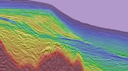
Data collected during acquisition undergoes extensive processing and imaging before it can be interpreted. Processing removes noise, corrects for wave propagation effects and enhances geological signals. Advanced imaging techniques, such as Full Waveform Inversion (FWI) and Reverse-Time Migration (RTM), transform the recorded reflections into accurate representations of subsurface structures.
Improvements in acquisition hardware, sensor technology and source design play an important role in the final image quality. Modern source technologies, such as extended low-frequency or enhanced frequency sources, help extend broadband signals that improve both resolution and depth penetration. Together, these advances allow geoscientists to produce more reliable subsurface models and reduce exploration risk.
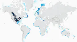
Multi-client seismic and regional coverage
Many offshore seismic surveys are conducted as multi-client programs. In this model, a geophysical company acquires data over prospective regions and licenses the dataset to multiple exploration companies. This approach spreads acquisition costs while creating high-quality regional datasets that can support exploration decisions for years.
Extensive multi-client libraries now cover many onshore and offshore basins worldwide, giving exploration teams access to modern seismic data without the need to commission new surveys. The integration between advanced acquisition systems, modern processing and imaging capabilities, and global data libraries continues to play an important role in supporting subsurface decision-making.
Foundation of subsurface understanding
Seismic acquisition remains one of the most important tools in energy exploration and development. By capturing detailed measurements of the subsurface, seismic surveys help geoscientists understand basin architecture, identify drilling targets and monitor producing reservoirs. As exploration targets become more complex, continued innovation in acquisition technology will play a critical role in improving image quality and reducing uncertainty.
From advanced streamer systems and high-capacity seismic vessels to OBN and UHR3D surveys, modern acquisition technologies continue to expand what is possible in subsurface imaging.
Want more on this topic?
Visit the Geosciences section for daily offshore news, project updates and technology advances.
Offshore's "What Is...?" series
Young professionals in the offshore energy industry often encounter technical terms and acronyms that seasoned subject matter experts (SMEs) know by heart—but aren’t always clear to the next generation. Offshore’s new “What Is…?” educational series aims to bridge that gap by providing concise, practical explainers for emerging professionals.
Some of the most-searched topics include:
- What is an FPSO?
- What is a dynamic positioning (DP) system?
- What is an SOV?
- What is directional drilling?
- What is CCS?
- What is seismic data acquisition?
- What is floating wind?
- What is an offshore substation (OSS)?
- What is a subsea production system?
- What is a blowout preventer (BOP)?
- What is a subsea tree (christmas tree)?
- What is an offshore riser system?
- What is a jackup rig?
- What is a subsea tieback?
If there’s an offshore energy subject you’d like to highlight in a brief explainer article (600-1,200 words), reach out to Chief Editor Ariana Hurtado at [email protected] for more information.
About the Author

Igor Marino
Igor Marino is technical marketing manager at TGS, where he leverages his 15+ years of geophysical experience to translate complex subsurface concepts into clear, relevant messages that resonate with both technical and commercial audiences. Based in Houston, he brings deep expertise in seismic acquisition, imaging workflows, full-waveform inversion and machine-learning applications in geosciences. He regularly shares insights on how integrated acquisition and imaging solutions enhance subsurface understanding. His work bridges technical depth with market relevance, contributing perspectives that help translate complex geoscience into practical exploration decisions.