Reshaping subsalt imaging in the US Gulf with integrated OBN surveys
Key highlights
- Long-offset OBN surveys provide extended recording offsets and flexible seafloor sensor placement, improving subsalt illumination and structural imaging in salt-rich environments.
- The Amendment and Apex programs have demonstrated the operational feasibility and significant imaging improvements achievable with integrated OBN workflows.
- The shift to dense, fully integrated OBN surveys enables true OBN-only imaging, reducing reliance on streamer data and unlocking complex subsalt prospects in frontier offshore basins.

By Igor Marino, Andrey Bogachev and Marc Rocke, TGS
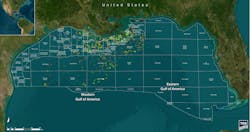
The Gulf of Mexico/Gulf of America remains one of the world's most important offshore petroleum provinces, supplying a significant share of US oil production. Despite decades of success, large areas of the deepwater Gulf remain challenging to image and interpret. Thick allochthonous salt, steep flanks and complex subsalt structures continue to limit confidence in prospect definition and depth positioning.
Wide-azimuth towed streamer (WAZ) surveys, introduced in the mid-2000s, represented a major step forward by improving azimuthal coverage and subsalt illumination relative to narrow-azimuth data. However, streamer-based acquisition is operationally constrained by achievable offsets and usable low-frequency signal-to-noise, both of which are critical for robust velocity model building beneath salt.
Over the past decade, long-offset ocean-bottom node (OBN) acquisition has emerged as a transformative alternative. Combined with enhanced frequency sources and elastic full-waveform inversion (FWI), OBN surveys are extending the limits of subsalt imaging in the US Gulf. Among these, the Amendment and Apex programs demonstrate the evolution of integrated OBN-led workflows and their regional exploration impact.
OBN changes the subsalt equation
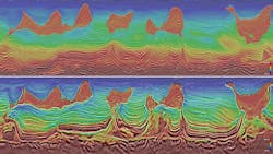
Salt creates extreme seismic challenges. Large velocity contrasts bend ray paths, while overhangs and welds create illumination gaps and shadow zones. Multipathing and scattering degrade signal quality, leading to structural uncertainty and mispositioned reflectors in conventional images.
OBN addresses many of these limitations at acquisition. Seafloor sensors are no longer constrained by cable length or towing geometry. Long offsets extend beyond streamer capabilities, enabling recording of diving waves essential for robust velocity updates in FWI workflows. Stationary receivers can also improve signal-to-noise ratio and repeatability, particularly at low frequencies. Flexible survey design supports denser spatial sampling and higher fold, improving illumination of steep salt flanks, deep faults and subsalt stratigraphy. The result is a dataset that supports more reliable depth conversion and structural mapping.
Surpassing acoustic limitations with E-DMFWI
Conventional acoustic FWI is constrained by simplified physical assumptions in complex salt environments, whereas elastic dynamic matching FWI (E-DMFWI) provides intrinsic advantages. By incorporating an elastic formulation into wavefield propagation, the method can simulate both compressional (P-waves) and shear (S-waves) waves, along with mode conversions, capturing more detailed subsurface information. The dynamic matching objective function allows for better alignment between modeled and observed waveforms, maintaining stability when dealing with extreme contrasts.
Beyond high-resolution velocity models, E-DMFWI delivers a complementary reflectivity product derived directly from the inversion. This FWI-derived reflectivity (FDR) often reveals subtle stratigraphic features, fault geometries and salt boundaries not readily apparent in migrated images alone. In offshore settings where drilling costs are high, this added clarity directly reduces exploration risk.
Low-frequency foundation of modern OBN
Successful FWI requires very low frequencies to recover long-wavelength velocity components and avoid convergence to local minima. Long-offset OBN acquisition alone is insufficient if the source does not provide adequate low-frequency energy.
Enhanced frequency sources extend the usable seismic bandwidth to very low frequencies. One example is the Gemini source, developed by TGS, which provides usable low-frequency energy approaching 1 Hz, supporting the bandwidth and penetration required at very long offsets for elastic inversion workflows. Its point-source design simplifies processing, while towing multiple sources from a single vessel improves acquisition efficiency. Environmental considerations are also embedded in the source design, supporting performance gains alongside responsible offshore operations.
Amendment 1 and 2: Establishing the baseline
The effectiveness of long-offset OBN combined with E-DMFWI was first demonstrated in Amendment 1 and 2 programs, acquired by TGS and SLB in the western Gulf. Compared with legacy WAZ streamer data, these surveys delivered clearer salt geometries, improved continuity of deep carbonate reflectors and more reliable basement imaging.
Equally important were the operational lessons. The projects demonstrated that large-scale OBN acquisition could be executed efficiently and that the resulting uplift in subsalt confidence justified the increased investment. These early programs established a technical and operational baseline that informed subsequent survey design.
Amendment 4: Designed for integration from Day 1
TGS’ Amendment 4, located in the Mississippi Canyon, marked another step change in OBN survey execution. Rather than retrofitting advanced processing onto existing data, the program was designed from the outset to integrate long-offset OBN acquisition, enhanced frequency sources and E-DMFWI.
The use of Gemini sources was a key differentiator. Ultra-low frequencies were critical for resolving long-wavelength velocity variations beneath salt and ensuring stable FWI convergence, as observed in early-out products. Combined with long-offset node geometry, Amendment 4 maximized the information content available for elastic inversion.
Operationally, using a single source vessel to tow multiple source arrays achieved high productivity while preserving the spectral bandwidth required for advanced imaging, reducing logistical complexity and delivering a dataset optimized for subsalt characterization.
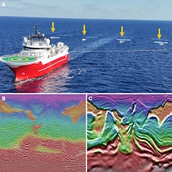
Apex survey densifying OBN geometry
Sparse, long-offset OBN programs have delivered major advances in subsalt imaging, largely through improved velocity models. Historically, sparse-node OBN workflows have been complemented by streamer data to enhance imaging resolution and provide mature starting velocity models. As exploration expands into frontier areas with limited streamer coverage and increasing geological complexity, additional challenges arise.
TGS’ multi-client long-offset OBN program, Apex, changes that equation. Designed as a pure OBN solution, the survey employs a much denser node grid, delivering significantly increased spatial sampling and fold compared with previous long-offset OBN multi-client programs. Combined with Gemini sources and E-DMFWI, Apex enables true OBN-only imaging, eliminating reliance on streamer data and improving subsalt velocity modeling and structural interpretation.
Although still in the acquisition phase, Apex reflects an integrated design philosophy that aligns survey geometry, node technology and advanced imaging, supported by operational efficiencies that make large-scale deployment feasible.
New standard for complex offshore basins
The transition from streamer-based WAZ surveys to fully integrated OBN programs represents a fundamental shift in subsalt exploration strategy. Long-offset and densified OBN acquisition provides the foundation, enhanced low-frequency sources supply the required bandwidth, and elastic FWI fully exploits the information contained in the recorded wavefield.
Together, these elements define a new benchmark for imaging in salt-dominated offshore basins. As exploration moves into increasingly complex areas, the lessons from the Amendment and Apex programs extend well beyond the US Gulf. Integrating OBN geometry, source design and imaging from the outset has become increasingly essential for unlocking the next generation of subsalt opportunities.
Acknowledgements: The authors thank TGS for support and permission to publish this work, and TGS Multi-Client and partners for the images and data examples shown.
About the Author

Igor Marino
Igor Marino is technical marketing manager at TGS, where he leverages his 15+ years of geophysical experience to translate complex subsurface concepts into clear, relevant messages that resonate with both technical and commercial audiences. Based in Houston, he brings deep expertise in seismic acquisition, imaging workflows, full-waveform inversion and machine-learning applications in geosciences. He regularly shares insights on how integrated acquisition and imaging solutions enhance subsurface understanding. His work bridges technical depth with market relevance, contributing perspectives that help translate complex geoscience into practical exploration decisions.

Andrey Bogachev
Andrey Bogachev is business development manager for North America Multi-Client with TGS, where he plays a key role in shaping commercial strategy and market positioning for advanced marine seismic solutions. Based in Houston, he works closely with E&P decision-makers and internal technical teams to define, structure and execute offshore programs that address complex subsurface risk and portfolio objectives across the Gulf of Mexico. He brings deep expertise in ocean-bottom node acquisition, including long-offset surveys, advanced source technologies and full-waveform inversion, paired with a strong understanding of market dynamics, capital allocation and value creation in multi-client seismic.

Marc Rocke
Marc Rocke is vice president of Geophysics and Navigation with TGS, where he leads the acquisition geophysics strategy and drives technical innovation in seismic data acquisition and navigation across global multi-client surveys. With extensive experience in marine seismic acquisition and a track record of technical contributions in multi-source and blended shooting techniques, he bridges field-scale geophysical operations with broader exploration goals. He regularly engages with industry partners and contributes insights into efficient, high-quality data acquisition in complex geological settings.