TGS, Viridien commence Laconia Phase III OBN survey in the Gulf

This latest phase in the large-scale Laconia ocean-bottom node (OBN) survey program spans about 150 Outer Continental Shelf blocks in the Gulf of Mexico.
June 26, 2025
2 min read

The Laconia Phase III survey will also utilize Viridien’s elastic full-waveform inversion and reverse time migration imaging technologies to deliver seismic data to support both exploration and development activities.

"Outstanding early-out results from Laconia Phase I clearly demonstrate the power of Viridien’s industry-leading elastic full-waveform inversion imaging technology for setting new benchmarks for subsalt imaging and reservoir delineation," Viridien stated in its June 19 news release. 

"The combination of very-long-offset OBN and the low-frequency Sercel Tuned Pulse Source (TPS) provides significantly deeper diving-wave penetration for E-FWI to resolve the complex salt geometries and sediments, producing a step change in subsalt imaging and highlighting exploration opportunities in the Paleogene trend with greater certainty."

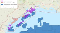
Fast-track data from Laconia Phase I is available, and fast-track data from Laconia Phase II is scheduled for August.

Related content:

Courtesy TGS
TGS-created Gulf of Mexico map showing seismic surveyed areas.
TGS has completed the Amendment Phase 4 ultra-long offset ocean-bottom node (OBN) survey in the US Gulf of Mexico.
June 24, 2025
Courtesy TGS
Gemini Enhanced Frequency Source
TGS has started acquisition of ultra-long offset ocean-bottom node (OBN) data for the Amendment 4 project in the US Gulf of Mexico.
April 2, 2025
Courtesy Sercel/Viridien
Laconia 3D Sparse OBN Survey - Gulf of Mexico
Shearwater's SW Tasman vessel completes an industry first, while Viridien sees offshore exploration gaining momentum.
Feb. 28, 2025
Courtesy TGS
Schematic illustration of the nominal vessel configuration and a photo of Ramform Hyperion acquiring the high-resolution CCS development survey for the Northern Endurance Partnership offshore UK. The configuration consisted of nine multi-sensor streamers with 50 m separation and a wide-tow quad source that was towed over the front end of the streamer spread. The resulting nominal acquisition bin size was 6.25 m x 6.25 m.
Acquisitions strengthen oil and gas, and new energy capabilities.
Sept. 18, 2024
Courtesy of Viridien Earth Data
The map illustrates the total coverage of phases 1 and 2 of Viridien’s Gulf of Mexico Carbon Storage Screening Study.
Viridien has completed Phase 2 of the GeoVerse Carbon Storage Screening Study of the Gulf of Mexico (GoM).
Aug. 28, 2024
Image courtesy of Viridien Earth Data; Block and operator data sourced from Wood Mackenzie Lens Upstream © 2024
The map displays the location of Viridien’s new Laconia 3D OBN survey.
Viridien has started the Laconia 3D ocean-bottom node (OBN) multi-client seismic program in the US Gulf of Mexico.
Aug. 27, 2024
Sign up for Offshore eNewsletters