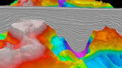
TGS will apply velocity model building and pre-stack depth migration to the merged dataset, including its proprietary DM-eFWI technology, to strengthen imaging of the pre-, intra- and post-Messinian salt intervals.
Imaging beneath the Messinian salt layer has long been a technical challenge in parts of the Eastern Mediterranean because complex salt geometries can distort seismic signals and obscure potential reservoirs. Improved subsurface imaging can help explorers better define prospects and reduce drilling risk ahead of future licensing opportunities.
TGS says the enhanced imaging should support prospect identification, particularly in areas that could be offered in a future licensing round.
Egypt has held several offshore bid rounds in recent years as it seeks to sustain domestic gas supplies and attract new exploration investment in the Mediterranean.
"EGY-2DRE2026 will give our customers a modern, regionally consistent view of a basin that has historically been difficult to image beneath its complex Messinian section," said David Hajovsky, EVP of Multi-Client at TGS.
Final products for an initial subset of 2D lines will be available in second-quarter 2027, with the remaining full project due to be completed early in 2028.