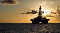
Viridien, BGP begin shallow-water 3D seismic survey offshore Guyana

Viridien and BGP have started a new 3D seismic survey offshore Guyana designed to improve imaging of shallow-water exploration acreage and support future licensing and development opportunities.

Why this news matters:

  • New seismic data could help unlock additional exploration opportunities beyond Guyana's prolific deepwater discoveries.

  • Modern reprocessing and imaging technologies may improve understanding of shallow-water resource potential and support future licensing activity.
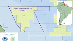
 

Viridien and BGP have started activities for the Guyana Shallow Water 3D Phase I project, under an agreement with the country’s Ministry of Natural Resources. 

The survey comes as Guyana continues to attract industry interest following a series of major discoveries in the ExxonMobil-operated Stabroek Block, which has transformed the country into one of the world's fastest-growing offshore oil producers. While exploration activity has been concentrated in deepwater areas, the new program aims to improve understanding of shallow-water prospectivity.

The program also has industry support.

BGP will acquire 3D data over shallow-water acreage across Lot 3. This will be connected to legacy surveys in the area that will later be reimaged by Viridien, using proprietary workflows such as shallow-water demultiple and time-lag full-waveform inversion.

Viridien expands Guyana presence

Separately, Viridien subsidiary Sercel recently secured a one-year contract from ExxonMobil to provide Marlin software for SIMOPS management on the Whiptail development in the Stabroek Block, highlighting the company's growing involvement in Guyana's offshore sector.

Marlin will assist pipelay and mooring installation operations.

According to the companies, the newly acquired data will be tied to existing seismic coverage and reprocessed using modern imaging technologies to provide a clearer picture of potential hydrocarbon resources across the surveyed acreage.

The software service provides a live, timebased geospatial view of offshore activities, providing vessel and asset awareness that teams need to plan, coordinate and conduct offshore operations safely in highactivity environments.

Exclusive content:

Courtesy Noble Corp.
Suriname emerges as a high-potential offshore E&P frontier
The next two to three years could see development drilling and new project FIDs.
June 11, 2026
Contributors:

About the Author

Jeremy Beckman

Staff Writer / Editor, Europe

Jeremy Beckman has been Editor Europe, Offshore since 1992. Prior to joining Offshore he was a freelance journalist for eight years, working for a variety of electronics, computing and scientific journals in the UK. He regularly writes news columns on trends and events both in the NW Europe offshore region and globally. He also writes features on developments and technology in exploration and production.

Sign up for our eNewsletters
Get the latest news and updates