Staatsolie seismic survey will investigate Suriname’s near-shore hydrocarbons potential
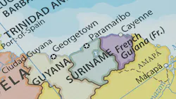
Staatsolie plans to commission a new seismic survey over Suriname’s shallow offshore area.
This extends from the coastline to halfway between offshore blocks 15, 52 and 58, in a region between the maritime borders with French Guiana and Guyana.
The survey will cover a 52,400-sq-km area, in water depths ranging from 0 m to about 500 m, and it should deliver insight into subsurface structures and the oil and gas potential.
Prior to the start of the campaign, ILACO Suriname will prepare a limited environmental impact assessment, in accordance with the guidelines of the country’s National Environment Authority.
Exclusive content:
Offshore's new educational series:
About the Author

Jeremy Beckman
Editor, Europe
Jeremy Beckman has been Editor Europe, Offshore since 1992. Prior to joining Offshore he was a freelance journalist for eight years, working for a variety of electronics, computing and scientific journals in the UK. He regularly writes news columns on trends and events both in the NW Europe offshore region and globally. He also writes features on developments and technology in exploration and production.