Presalt imaging advances aid hunt for Brazil’s next super-giants
Jo Firth
CGG
New techniques clarify presalt sequences, faulting
Brazil’s offshore seismic market is booming once more after many years of inertia. The suspension of offshore licensing rounds for five years, combined with restrictions on foreign operators in the presalt region, had a negative impact on seismic activity. However, the new government’s lifting of the ban on foreign operators on presalt contracts has re-started exploration. In addition, the introduction of a long-term licensing round calendar has boosted activity in the seismic sector and resulted in the increased activity of major international oil companies in the area.
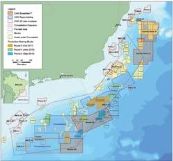
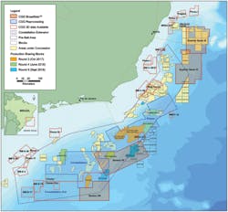
CGG had faith that an upturn would come in Brazil, believing it was the right place to invest when others were turning away. The company, optimistic that the presalt areas would eventually be opened for licensing, has kept at least one vessel operating in Brazil over the past five years. During this time it has acquired several new surveys over the presalt area and reprocessed large areas of existing seismic data, taking advantage of recent step-change advances in subsurface imaging to create a contiguous volume of state-of-the-art, multi-client, broadband seismic data covering over 100,000 sq km (38,610 sq mi) in the Santos and Campos basins, and over 20,000 sq km (7,722 sq mi) more in the Espirito Santo basin.
CGG multi-client data sets in Brazil’s presalt area.
Although the process of obtaining environmental permits in Brazil has become more streamlined of late, it can still take time. By concentrating on multi-client surveys and starting the permit process as early as possible, CGG has been able to offer the industry very large volumes of high-quality seismic data that image the presalt structures in advance of the licensing rounds.
Source rock characteristics
Although the Campos basin was initially the country’s most prolific basin, it was Petrobras’ discovery of the Lula field (formerly Tupi) in the Santos basin that paved the way for major interest in exploration in the presalt region. Numerous mega-sequences can be identified in the presalt, as well as a highly faulted, pre-rift basement. The prolific source rock is made up of early syn-rift Lacustrine shales and mudstones (Mann, 2013). Directly above are thick, syn-rift sediments, consisting of a lower and upper sequence. These sequences can be differentiated easily from each other, due to the changes in sediment character and stratigraphic architecture, along with the termination of extensional faults at the base of the post rift. The upper syn-rift is important for petroleum exploration in the northern Santos basin, as it contains the main carbonate coquinas reservoir for the Franco and Libra fields. The boundary between the upper syn-rift and post-rift sequence is marked by an erosional unconformity that represents a major change in depositional environment.
This unconformity indicates a change from an active rift environment to a period of thermal subsidence. During this phase, non-marine microbial carbonates were deposited, with some arguing for build-ups forming above faulted-basement highs and others for deposition in extensive shallow evaporitic lake systems (Buckley et al., 2015; Wright and Barnett, 2017). These post-rift sediments can be identified on seismic data by uniform, parallel reflectors and aggradational geometries. Recognition of this sequence is key to establishing potential reservoirs of non-marine carbonates, as observed in the Lula field. All presalt reservoirs are sealed by a thick sequence of evaporites that extend laterally across the basin, consisting of deformed halite, inter-bedded with autochthonous anhydrite and clastic sediments of Aptian age. Up to this point, the fields and discoveries have been mainly in large structural closures associated with tilted fault blocks and basement-rooted palaeo-highs.
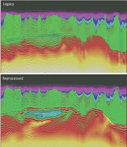
Comparison of legacy and final Reverse time migrations from Constellation with velocity model overlays. (Images courtesy CGG Multi-Client & New Ventures)
Seismic imaging challenges
The thick, deformed layers of salt at depth present a challenge for seismic reflection imaging. The use of broadband acquisition with deep-towed streamers for improved bandwidth, especially at low frequencies, longer streamers, and advanced depth migration algorithms all help address these challenges (Duval, 2014). Wide-azimuth acquisition techniques would also aid illumination at depth, but currently multi-vessel acquisition is not permitted offshore Brazil for environmental reasons. However, there are plans to overshoot existing seismic data in some areas to acquire dual-azimuth data sets, and full-azimuth data have been acquired using nodes in some relatively small areas. The rapid advances in velocity modeling and depth imaging algorithms over recent years, combined with improvements in deghosting and bandwidth extension, have meant that even relatively new existing data can be reprocessed to deliver outstanding improvements. In addition, the data are now being processed to greater depth; in the Pulsar Survey reprocessing of Santos VIa and VIb and Campos II, high-quality images are being output to a depth of 16 km (9.9 mi), and in Santos VII to 20 km (12.4 mi), providing a much clearer picture of the subsurface and enhancing understanding of deep basinal features.
All of CGG’s new and reprocessed surveys in this area are being processed through a similar high-end sequence, including detailed de-noise, 3D ghost wavefield elimination, multiple attenuation, anisotropic model building using non-linear tomography, and full-waveform inversion updates. The main processing challenges are obtaining high-resolution data, with the broadest possible bandwidth and the best signal-to-noise ratios at both low and high frequencies, and velocity model-building that adequately reflects the complexity of the deep presalt target and the salt structures. In addition, the reprocessing projects have required merging of multiple surveys acquired with different azimuths.
One of the key steps in improving the legacy data for the reprocessed surveys was the joint 3D deghosting and designature (Poole, 2016), which was applied after noise attenuation to remove swell noise and seismic interference. Near-field hydrophone recordings were employed, where available, to estimate far-field signatures for use in the designature. For reprocessing surveys where these recording methods were not available, far-field signatures were estimated from the direct arrivals (Davison 2015).
Velocity modeling advances
CGG has deployed the most recent, advanced velocity modeling tools in these surveys. The company produced initial tilted transverse isotropy (TTI) velocity models using tomography and subsequently updated for the post-salt using diving-wave full-waveform inversion (FWI) followed by a high-resolution tomography update. Although diving-wave FWI does not penetrate to a sufficient depth to reach the presalt targets, it provides the accurate velocity models of the overburden that are essential for accurate imaging of the deep data. Further iterations of localized post-salt velocity updates were performed as necessary, including additional FWI and structurally-guided tomography updates. Additional tomographic updates were also made for the intra-salt along with salt scenario testing followed by dip-constrained and structurally-constrained tomography for the presalt. For the most recently processed surveys, reflection FWI (R-FWI) was used for the deeper horizons (Gomez, 2017), but this was still in the research phase at the time of the Constellation reprocessing. This demonstrates the rapid advances that are continually being made in the field of model building.
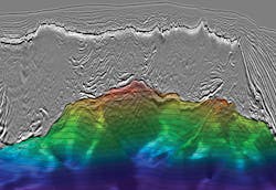
Image from Santos VII with interpreted Base of Salt. (Image courtesy CGG Multi-Client & New Ventures)
The imaging improvements achieved by reprocessing of even relatively recent data, using modern velocity modeling, are clearly shown in the image above. The base of the salt is much more clearly defined in the reprocessed version, there is considerably more low-frequency penetration at depth, and greater velocity detail, conformable with the seismic, in the shallow section. Details of the presalt faulting are also much clearer. The uplift in imaging shown in this example is typical of the improvements seen on the reprocessing throughout the basin. The new data sets, which have the benefit of being acquired with broad bandwidths and long offsets, to be optimal for FWI, deliver well-focused Base Salt reflectors.
In some areas of the Constellation reprocessing survey, multiple energy remained in the presalt, generated by layers in the post-salt overburden. In these areas, interbed multiple attenuation (IMA) was successfully tested. A 3D data-driven IMA based on the Marchenko method (Pereira, 2018) was applied as this does not require a generator to be specified. This technique discriminated well between primaries and multiples, delivering uplift in inlines, crosslines and depth slices, and could be applied more widely if required.
Constellation JumpStart
To complement the seismic data sets, CGG has created an integrated JumpStart package, designed to accelerate industry understanding of the petroleum systems and support exploration in this region. This geoscience package provides a comprehensive, consistent resource of easily accessible data for evaluating petroleum systems, assimilating all the available geoscience data and framing it within a geological context.
All the existing information has been amalgamated and reviewed, focusing on the main petroleum geology components, such as the source rock, the reservoir, the charge, the trap, and the migration pathways. Tools and databases from the Robertson New Ventures Suite were used to investigate paleo-geographies, paleo-climates and analogues to provide a framework for interpretation of the new seismic data, basin model building and play-fairway analysis. This framework creates a regional context for the petroleum systems within the survey area itself and consequently provides wider exploration insight into the presalt petroleum systems of the Brazilian margin.
All 43 available wells in the project area were assessed as part of the well study for the JumpStart package. Based on their available data, these were reviewed, aligned, evaluated, and then interpreted by petrophysical, geochemical, and geology specialists. Three presalt horizons identified from the well data were evaluated in more detail in terms of the source rock richness and thermal maturity, using geochemical analysis of samples from the well cores.
Potential fields data were interpreted alongside the seismic data to help characterize the deep basin structures, where seismic imaging reaches its limits, and to provide regional linkage. On completion of the seismic processing, a structural and stratigraphic framework was interpreted using key horizons, and seismic attributes (pre- and post-stack, calibrated to the upgraded well data) were extracted to map reservoir facies and highlight the potential presence of hydrocarbon fluids.
The deepwater region of Brazil’s presalt province covers an area of more than 122,000 km (75,807 sq mi), with many discoveries, some of them giants. The discovery of oil in the presalt Santos basin led to a tenfold increase in known reserves, now estimated at ~30,000 MMbbl (recoverable) after just 10 years of presalt exploration. This exploration has seen very high success rates, with 13 of the 16 exploration wells reviewed as part of the JumpStart study resulting in new discoveries. Lula, Brazil’s first super-giant, contains estimated recoverable reserves of 8.3 Bboe. The successes in this region can be attributed to the quality of the presalt petroleum system, which has been unlocked by improvements in seismic imaging, as demonstrated by the results of the processing and reprocessing described earlier, and developments in deepwater drilling, as the majority of the presalt play fairway lies in water depths in excess of 2,000 m (6,562 ft).
After 10 years of successful presalt exploration, the largest structural highs of the Constellation survey area have been identified. Future exploration is therefore dependent on the petroleum prospectivity away from the major highs and in other areas of the basin. Studies of the area, such as CGG’s Constellation integrated JumpStart program, have shown that the key elements of the petroleum system, i.e. source, reservoir and seal, are present and of high quality with low risk in many areas away from the main highs. Therefore, identification of traps remains the critical element for unlocking the remaining potential and recognizing missed opportunities. Smaller satellite structures and broad low-relief closures can be observed in many areas of the presalt seismic data and additional potential is thought to lie in stratigraphic traps associated with the many unconformities and pinch outs that have now been clearly imaged.
The huge volume of high-quality seismic data available in this prospective area provides an invaluable resource for exploration teams. There are plans to expand the well study to include all available wells in the presalt region. The integrated geoscience study, with its reviewed and recalibrated wells, delivers a strong framework and starting-point for interpretation of the area, and if there is sufficient industry interest this will be expanded to cover the entire presalt region. It is only a matter of time before new discoveries are made in the area, and there may well be further super-giants waiting to be found. •
The author
Jo Firth is a senior geophysicist with CGG based in the UK. She has worked for the company for 34 years and has been involved in subsurface imaging, training and technical marketing. She graduated from the University of Sussex with a degree in Environmental Science in 1980.
The author would like to thank CGG Multi-Client & New Ventures for permission to publish this article and to show the images.
References
• Buckley, J.P., Bosence, D. and Elders, C. [2015]. Tectonic setting and stratigraphic architecture of an Early Cretaceous lacustrine carbonate platform, Sugar Loaf High, Santos Basin, Brazil. Geological Society, London, Special Publications no. 418, 175-191.
• Davison, C. M., & Poole, G., (2015), Far-field Source Signature Reconstruction Using Direct Arrival Data, 77th EAGE Conference & Exhibition 2015, Madrid
• Duval, G., (2014), Uncovering the Brazil-West Africa Connection, Oil & Gas Technology, February 2014
• Gomes, A, & Nicolas Chazalnoel, N., (2017), Extending the reach of FWI with reflection data: Potential and challenges, SEG International Exposition and 87th Annual Meeting Extended Abstracts pp 1454-1459
• Mann, J., (2013), Broadband seismic imaging improves subsurface mapping of Santos basin pre-salt reservoirs, World Oil, September 2013 issue, pp 33-38.
• Pereira, R., Mondini, D., Donno, D., (2018), Efficient 3D Internal Multiple Attenuation in the Santos Basin, 80th EAGE Conference & Exhibition 2018, Copenhagen
• Poole, G., King, S., & Cooper, J., (2016), Simultaneous Source Designature and Receiver Deghosting in the Joint Shot-receiver Domain, 78th EAGE Conference & Exhibition 2016, Vienna
• Wright, V.P. and Barnett, A.J. [2017]. Critically Evaluating the Current Depositional Models for the Pre-Salt Barra Velha Formation, Offshore Brazil. AAPG Search and Discovery, Article #51439 (2017).


