Philippe Alain
iXblue
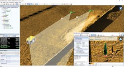
Real-time acoustic positioning of an ROV for sonar target inspection. (Image courtesy iXblue)
iXblue provides solutions and services for navigation, positioning, and seabed mapping, from components to sensors. The ‘vertical integration’ of key technologies such as fiber optical gyroscopes, acoustic transducers and others has been a major factor in the development of new tools in the subsea industry, in partnership with contractors and clients.
The company’s Sonar Division develops seabed mapping systems to provide high-performance sonars such as the Sams (Synthetic Aperture Mapping Sonars) product line with optimal geo-referencing of the data. Mapping, deploying or recovering subsea assets all require high-resolution imaging with positioning accuracy: iXblue develops the necessary software for use in real-time subsea operations and for post-processing of the collected data.
Geophysical sensors such as side-scan sonars, sub-bottom profilers and magnetometers are employed when there is a requirement for detailed imaging and understanding of seabed features and near-surface geology. Applications vary from preliminary site survey to cable or pipeline routing, as-laid surveys and inspection, to decommissioning surveys. As all data must be geo-referenced, processed, mapped and interpreted, an integrated software solution is necessary. Over the past 30 years the company’s Delph software suite has addressed these needs, from data acquisition to the delivery of cartographic layers, with processing and analytical capabilities expanded or adapted over time to complement the evolution of new subsea mapping technologies.
During the 1980s, when the use of sonar technologies expanded in the offshore subsea industry, it was common practice for geophysicists and geologists to directly operate the sonar sensors onboard vessels as the collection of raw analog data required some tuning for the subsequent reprocessing. Once it became possible to record digitized data on computers, geophysicists could use the same acquisition software with the added capability of replaying the data with more advanced processing techniques.
Delph software was among the first commercial seismic and side-scan sonar data acquisition software to be introduced in the latter part of that decade, and development continued through the 1990s with better and faster processing as computer technology also progressed. As the positioning accuracy improved, consolidating datasets in GIS (geographical information systems) became more commonplace in addition to traditional fix numbers and kilometer (or mileage) points. All data finally became available and manageable as digital maps. For immediate data quality control (QC), a real-time mosaicking feature was introduced in the mid-1990s to provide simultaneous acquisition and mapping control to the geophysicists onboard.
Subsequently digital sensor technology emerged and underwent rapid expansion. As most equipment was delivering digital raw data, the need for tuning decreased and the roles onboard survey vessels changed. Survey technicians could now perform and monitor the acquisition of all sensors with minimal operations while geophysicists and geologists were able to focus on processing and interpretation. To accompany this transition iXblue embarked on a dual-development - Delph Acquisition software for surveyors, and Delph Interpretation software for geophysicists. In the case of Delph Acquisition, the focus was on real-time control of incoming data, raw data logging and large QC indicators that could be easily monitored in a survey room screen wall. Delph Interpretation was a dedicated analysis tool, designed to assist geophysicists’ offline processing capabilities.
With the new generation of Delph Interpretation, one geophysicist can now cope with larger datasets and higher resolution data in a much shorter timeframe due to software automation. From processing to mapping, all operations can be run in batches of processing, allowing complete surveys to be handled in fewer steps, 10-20 times faster than with the previous-generation software. Automated seabed classification and sonar target measurement are also part of this new workflow which allows users to minimize software manipulation.
Geophysicists can better focus on QC and interpretation of data while reducing the risk for errors, leading to improved overall data quality. When geophysical data delivery time is critical to missions such as pipeline surveys of cable routing jobs, Delph Interpretation software can also be used in real-time, bridging the acquisition and interpretation software to automate processing and mapping. In addition, Delph automated workflow has been applied to assist both single and multiple AUV surveys where the processing time between dives is key and no backlog can be allowed to accumulate.
Another important consideration for data interpretation is the ability to combine multiple sensors in one single environment with visualization and analysis capabilities. In this regard the Delph GIS module evolved into a 3D cartographic environment in which all the data combines automatically, with each sensor contributing to a better understanding of a dataset. Analysis of high-resolution sonar targets complements the bathymetric model, magnetometer anomaly detection and sub-bottom profiler cut-section to confirm the presence of surface/buried targets and their subsequent classification. This process requires a high level of accuracy in data geo-referencing with optimal integration of the positioning and motion data. The 3D combination of all the data provides a global-scale QC that quickly highlights any inconsistency in vertical or positioning corrections as well in feature interpretation.
Building a software product line is a continuous effort to meet user requirements in terms of productivity and quality control. To achieve this, iXblue is working on a broad range of solutions in close cooperation with major subsea contractors to anticipate future needs of subsea surveys, from sensors to deliverables.


