Electromagnetic sounding bridges seismic and drilling
Dry hole and appraisal well savings possible
Lucy MacGregor
OHM Ltd.
Active source electromagnetic (EM) sounding bridges the gap between 3D seismic and exploration drilling. While 3D seismic identifies the geological structures that may contain hydrocarbons, under many circumstances it does not reveal the presence of hydrocarbons themselves.
Active source EM sounding detects and delineates the resistive sub-seafloor layers, which can be associated with hydrocarbons. Under the right circumstances it can confirm the presence of hydrocarbons by identifying their resistive characteristics. This means that the possibility of drilling dry exploration wells is significantly reduced, as is the need for extensive appraisal drilling.
null
Application of the active EM sounding technique can cut at least 50 cents per barrel – around 10% – off deepwater exploration costs.
The technique has been proved on a number of "placebo" trials on well-known fields and on soon-to-be-developed deepwater projects. Here, client a priori knowledge of the subsurface meant that the technique was subjected to severe – but successful – tests. It is now in commercial use on deepwater exploration and reservoir evaluation projects worldwide, including West Africa and Norway.
History
Active source EM sounding is not new. The academic geophysical community, notably at the Scripps Institution of Oceanography, USA, and Cambridge University, UK, has used it for over 25 years to look at hydrothermal venting and other mid-ocean ridge volcanic phenomena.
It became clear that given further development of the technology, active source EM sounding had the potential to be applied to hydrocarbon prospecting. That potential was taken up by the UK's Southampton Oceanography Centre, which, after several years of oil industry involvement, spun off Offshore Hydrocarbon Mapping Ltd. (OHM) in March 2002.
Process
Active source EM sounding uses a dipole source towed just above (typically 30 m) the seafloor. The dipole emits a low frequency (a few tenths to a few tens of Hz) EM signal that diffuses outwards through the water column and into the underlying sediments. The resulting electric fields are measured by an array of receivers on the seafloor.
Studying the variation in the amplitude and phase of this received signal as the source is towed around and through the receiver array allows the resistivity structure of the underlying sediments to be determined at scales of a few tens of meters to depths of several kilometers. A multitude of source transmission lines is recorded on seafloor-mounted receivers to create a multi-dimensional model of sub-seafloor resistivity.
There is a large resistivity contrast between hydrocarbon-saturated reservoirs and the surrounding sedimentary layers that are saturated with aqueous saline fluids. The figure shows how thin resistors at depth significantly affect the active source electric fields within the earth. The EM source induces current flow within the earth. When these currents encounter a resistive body they are forced to flow around it. This means that even a target layer that is thin compared to its depth of burial has a dramatic effect on the pattern of current flow in the earth, and this effect can be measured at the seafloor.
Yes/no survey
Two types of active source EM sounding survey are currently undertaken: one for exploration programs and one for appraisal work in support of field development.
The "yes/no" exploration survey is the simplest. Traditionally, 2D/3D seismic work produces a portfolio of prospects in an area. The high cost of drilling makes it economically impossible to drill all of the most promising prospects and so usually only a few are drilled with perhaps 33% success. With an active source EM sounding yes/no survey the whole of the portfolio may be tested and fully understood. Subsequently, only those prospects that have been shown to have a high probability of containing hydrocarbons are drilled.
A yes/no survey begins with an assessment of target suitability based on a simple geological model. This is followed by more complex modeling on which the decision to undertake the offshore survey is based. Each survey takes about five days per wellsite with data processed on board the survey vessel.
null
null
The survey requires a grid of receivers on the seafloor, which are deployed from the survey vessel in a pre-planned pattern. The vessel then tows the dipole transmitter through the survey area on carefully positioned tracks. The geometry of the grid leads to valuable clues to hydrocarbon detection: the in-line and broadside geometries give different electric field responses for different types of resistive bodies.
A normalized field clearly shows the difference between inline and broadside fields and the effect of a thin resistive hydrocarbon layer. Further evidence of the way in which survey geometry reduces the uncertainty of result is shown where the geometric effect distinguishes between thin resistors such as hydrocarbon reservoirs and thick resistors such as salt bodies.
Tools
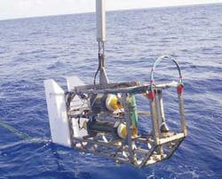
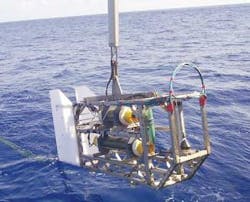
OHM's dipole transmitter system is called DASI (deep-towed active source instrument). The first version, still in use, transmits a stable phase, low frequency EM signal to give penetration to about three kilometers into the seafloor.
The latest source, DASI 3, has an output several orders of magnitude more powerful, to give a dramatic increase in penetration depth. It also allows for significantly more control over the transmitted signal.
The DASI 3 source, which has just completed sea trials, incorporates a $300,000 state-of-the-art cable system from Cortland Fibron, UK. The first component is a 6,000 m tow cable with a central signal-carrying fiber optic overlain by electrical power cores and sheathed in polyurethane. Two layers of ultra-high tensile galvanized wire armor are applied over the polyurethane sheath. It is the unique high tensile strength of these armor wires that produces a cable of considerably smaller diameter than those currently in use.
The second component is the 300 m active element cable towed by the new source, which supports the electric dipole to transmit the electromagnetic signal. Also now being introduced is a new generation of seafloor receiver, which uses military technology to provide greater sensitivity and better data handling.
Appraisal survey
The second type of EM active sounding survey is for reservoir appraisal after a discovery well has been drilled and proved. Traditionally, multiple appraisal wells are drilled to delineate the area and characteristics of the reservoir. But these expensive appraisal wells give only point-source information. An active source EM hydrocarbon survey enables the full lateral extent of the reservoir to be mapped to high accuracy and at considerably lower cost.
In-line and broadside geometries give different electric field responses for different types of resistive bodies.
The at-sea survey technique for appraisal projects is essentially the same as that for yes/no surveys except that additional seabed receivers are deployed, with spacings from a few hundred meters to a kilometer or more.
Active EM surveys of both types are rapidly becoming part of the mainstream of exploration and development activity. However, they are currently confined to deepwater work - typically 1,000 m or greater.
This is because of the physics of the technique. When the subsea source generates its signals, energy goes up as well as down. In shallower water, where water depth is less than 1.7 times reservoir depth, signals that have interacted with the air overwhelm the sub-seafloor signals at the seabed receiver.
A new OHM development program, now at an advanced stage in conjunction with an oil company partner, seeks to overcome this problem so that the active EM technique may be applied in waters as shallow as 100 m. This could greatly extend opportunities for small, independent operators with restricted exploration budgets. At-sea trials are underway.
OHM is also working on applying the technique to monitoring reservoirs during prod-uction. This would enable better planning of depletion and thus higher recovery rates; there would be significant cost savings over current monitoring techniques; oil/water content could be monitored; and there would be the potential for measuring gas saturation. ;
Author
Dr. Lucy MacGregor is chief scientific officer with OHM Ltd. Her PhD was earned at Cambridge University for her work on controlled source electromagnetic sounding of the Reykjanes Ridge near 58° N. Dr. MacGregor may be reached at tel: +44 (0)870 429 6584 or email: [email protected].


