Greenland's new policies add flexibility to nominations
West Greenland is significantly under-explored with only six wells drilled on the whole shelf. The government has moved steadily to encourage exploration and has recently altered its licensing policies to encourage oil companies to pursue and develop new projects in the region. Two areas, Fylla and Sisimiut, have received the most attention. Work continues on these licenses, but at a measured pace.
Total seismic coverage over the shelf is only 60,000 line-km and most of that coverage is over 20 years old. The region is larger in area than the Viking-Central Graben complex of the North Sea. Oil seeps occur onshore and there are significant indications of hydrocarbons offshore. The region is navigable, ice-free year-round, and icebergs are rare.
With all these positives, the region has been sidelined the past year by the low oil price environment, the ready availability of new deepwater licenses off Africa, and the relative ease of finding new fields in established theaters like the Gulf of Mexico and the North Sea. As a frontier region with little established infrastructure and far from North American and European markets, West Greenland has a number of hurdles to overcome before it can evolve into a vibrant exploration and production theater.
Fylla, Sisimiut seismic
Data collected by the Geological Survey (1990-1992) and a speculative survey by Western Geophysical (1990) reveal very large tilted fault blocks with prominent flat-spots. The flat-spots may indicate the presence of a large gas-water contact. There is speculation about the presence of and oil rim underneath this seismic indicator.
This area came to be called the Fylla Structural Complex. Nunaoil gathered additional speculative data over this complex in 1994. In late 1996, a license covering 9,487 sq km was awarded to a consortium composed of Statoil (operator), Phillips Petroleum, Dansk Olie-og Naturgas (DONG), and Nunaoil. In 1997, an additional 2,000 km of in-fill seismic was gathered. More seismic will be shot in 1999 leading to an exploration well in 2000.
A year later (June 1998), a 4,744 sq km block (Sisimiut) was awarded to a consortium of Phillips (operator), Statoil, DONG and Nunaoil. Additional seismic will be acquired in 1999. Drilling on this license will be decided after evaluation of the new seismic data.
Two additional speculative seismic surveys were gathered in 1998 by Fugro-Geoteam and Nunaoil. In addition, Fugro-Geoteam and Danpec have undertaken the task of reprocessing the 1970's vintage 2D data set.
Geology
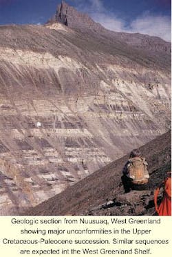
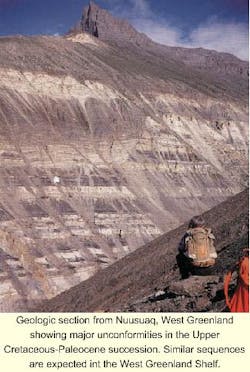
West Greenland was once attached to the North American continent. Its development is a story of continental separation and marine sediment deposition. In the Early Cretaceous, rifting began creating a series of half-grabens that filled with clastic material. During the Late Cretaceous rifting slowed and the sea level rose depositing a mudstone sequence that draped many of the half-graben blocks.
Beginning in the Early Paleocene, vulcanism extruded a thick sequence of basaltic lavas, generally north of 68°N. In the beginning of the Eocene, spreading forces opened the Davis Strait. Sediments washing off the Greenland continental land mass gradually covering the half-graben structures. This deposition was interrupted in the Oligocene by a widespread erosion event, an unconformity. West Greenland's southern offshore shelf is now a passive margin similar to the east-coast of Canada and the United States.
Widely distributed source rocks exist in the regional mudstone sequence and in the marine and deltaic mudstones. Similar rocks exist in Canada, especially on Ellesmere Island in the arctic. Upper Cretaceous to Lower Paleocene sources were found in Greenland's onshore Nuussuaq Basin. Geochemical evidence suggests at least five distinct oil types with a wide regional distribution. Traps and reservoir rocks are plentiful.
New licensing round
In April 1999, the government of Greenland and the Danish Minister for Environment and Energy authorized a new licensing round. This was the culmination of a new licensing policy to stimulate petroleum exploration around Greenland. The policy provides a framework, licensing procedures, and a timetable for future oil and gas activities in Greenland. In advance of the licensing round a nomination procedure will be conducted during the winter of 2000-2001. Potential applicants are invited to nominate the areas they would like to have offered for licensing.
The formal opening of the new licensing round will be by invitation letter on March 1, 2001 for areas offshore West Greenland between 63?N and 68?N. The licenses will be awarded in 2001. The "open door" will begin October 1, 1999 for applications covering areas between 60?N - 63?N and 68?N - 71?N The closing data is scheduled for October 1, 2001. For more information contact the Geological Survey of Denmark and Greenland, Tel: +45-38-14-20 or Fax: +45-38-14-20-50.

