Theory links lithospheric rotation to possible abiogenic oil re-charge

Most oil and gas fields in the Gulf of Mexico and Caribbean areas are located in deltaic Tertiary sandy formations of varied origins and ages. They occur around and above diapiric salt domes and in anticlines and faults. The producing carbonate formations are Upper Jurassic-Cretaceous in age.
The Upper Mesozoic-Early Tertiary producing formations, along the American Gulf coast, are onshore, whereas those of Upper Tertiary-Quaternary are offshore. Oil and gas production is found in serpentinite in Cuba, in pre-Cretaceous igneous basement rocks in Colombia, and on the western side of Lake Maracaibo, Venezuela. The oil gravity ranges between 7° API and 50° API.
Is it possible that some, or perhaps quite a bit, of Gulf of Mexico oil reserves are biogenically formed? Hydro carbons would not form from dead organisms in the oxygenated shallow depths of the Gulf of Mexico unless an impervious layer covered the organisms. Could the oil be formed by combining carbon (C) and hydrogen (H) at 300-500° C under high pressure in subduction and rift zones? Carbon is derived from carbon dioxide released from fractured mafic minerals in subducted basalt and lithosphere, and from the dissociation of calcium carbonate in subducted limestones. Hydrogen is derived from seawater in the subducted rocks.
History and distribution
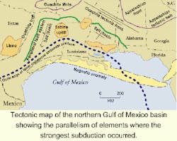
Structurally, oil distribution in the southern US appears to be related to the Rio Grande Rise and Sabine Uplift. These locations match the hydrocarbon distribution from the Rio Grande to west-central Mississippi. The Upper Mesozoic-Cenozoic uplifts, and the successive diapiric movements of salt domes and sheets generated growth faults along, and tensile faults above, the domes, in addition to anticlinal and other structures in the deltaic sands. The widespread Jurassic salt deposits fed the salt domes, and was precipitated from an epeiric sea, before the Gulf area was widened by the Upper Tertiary clockwise rotation of South America.
Subduction beneath the northern coastal area of the Gulf of Mexico created today's topography from the Florida Panhandle-Alabama area west to the Rio Grande, and from the Gulf Coast north to the Ouachita Mountains. These boundaries delineate the oil producing land inside the Peripheral Fault System (PFS).
Westward from Florida, a portion of the Atlantic Coast NE-trending magnetic anomalies, was found to have changed its direction from NE to E-W with a pronounced northward curvature into Louisiana and Texas. The subduction's compressional stress probably re-oriented the southern part of the Appalachians, including the buried Ouachita Inner Zone and Ouachita Front. The northward curvature of the E-W trending magnetic anomalies, the bearing of arches within the PFS, the directions of the Buried Ouachita Inner Zone, and the Ouachita Front all appear to be parallel to the PFS.
Continental rotation
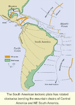
The Gulf of Mexico rift zone strikes NNE along the western half, and E-W along the eastern half. The Gulf floor spreading and subduction, therefore, were WNW along the northern half of the Mexican Isthmus and the Texas Gulf Coast, and ESE along the Campeche Sound, west of Yucatan Peninsula. The spreading and subduction along the eastern half of the rift was northward along Louisiana, Mississippi, the western half of Alabama, and the Florida Panhandle, and southward along the eastern Yucatan-Campeche Peninsula.
The southeastward subduction began with the Upper Tertiary opening of the SW-NE trending rift zone along the northern part of the Caribbean Sea and continues to be active. The clockwise rotation of South America caused the rifting. The seafloor spreading in the Caribbean Sea runs southeastward, causing the subduction beneath northern Colombia, Venezuela, and Trinidad. Such spreading fractured and faulted the rocks, and reoriented the northern Andes, while the clockwise movement of South America continued to exert compressional stress on Central America and Mexico. Costa Rica, Panama, the Antilles, and Lesser Antilles Islands were not affected by subduction.
Barbados yielded some petroleum because it was subducted along with Trinidad. The loss of light hydrocarbons was noted along northern Colombia, Venezuela, and Trinidad. Barb ados and the Lesser Antilles Islands were drifted and bent westward. During the westward rotational bending, subduction may have taken place and hydrocarbons may have formed. These were later burned by volcanic activities or lost to the atmosphere. South America rotation is supported by:
- The northwestward course of the Cordilleras, between Alaska and Panama, has changed to southward at the southern end of Panama.
- Due to the Cordilleras' break in SE-Honduras/ Nicaragua, and the clockwise rotation of the broken portion along northern Colombia and Venezuela, the width of the Cordilleras shrank in Costa Rica, and almost disappeared in Panama.
- The northern Andes split into several thin and elongated parts in northern Colombia, and their reorientation to E-W in northern Venezuela was due to the effect of the southeastward compressional subduction of the basaltic flows, which came from the Caribbean rift.
- The northeastward Cordillera's bending in Honduras/Nica ragua, and the southwestward bending in Costa Rica and Panama, were accomplished under the compressional stress of the rotation at the southern end of Panama.
- The crustal breaks and shears, across the Cordilleras, in the Mexican Isthmus, and in Central America were due to the compressional shearing stress exerted by the rotational movement of South America.
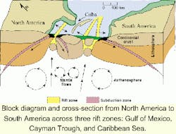
- The three rift zones in the Gulf of Mexico, Cayman, and Caribbean were opened because of the breaks caused by South America's rotation.
The cause of the post-Cordilleras rotation of South America would logically be the pressure on the northern portion of South America, from Venezuela to the eastern-most point of Brazil, exerted by the bulge of the mid-Atlantic rift. This also accounts for the bending and displacement of the Antilles and Lesser Antilles island arcs.
Abiogenic origin?
The origin of hydrocarbons in the region appears to be not unlike that found in the Persian/ Arabian Gulf area. In both locations, many questions cannot be answer ed by relying on organic origin alone. For example:
- If hydrocarbons originated from dead organisms, one should also find hydrocarbons along the eastern coast of US (which was not the case). Could the oil found in Newfound land have been generated abiogenically, due to the island's detachment from the Canadian mainland?
- Commercial hydrocarbons were exploited along the western coast of the Americas. The explanation for such a difference between the east coast of the US, and the west coast of the Americas, was the subduction of the Pacific Ocean floor below the westward drifting American continent. There appears to be no subduction along the east coast.
- If the origin of hydrocarbons was completely organic, shouldn't oil and gas have been found by drilling onshore and offshore Florida? The only two locations where oil and gas was found in Florida were in the panhandle along the northern border with Alabama, and in the southern part. In both locations, the petroleum seems to have been related to subduction and shearing. Accordingly, hydro carbons were not found anywhere else in Florida possibly because it was spared from rifting, seafloor spreading, and subduction activities.
Hydrocarbon origin
Where and how did the hydrocarbons originate? The following are some thoughts on controversial and unsolved problems surrounding this issue:
- Oil fields appear to be located in porous-permeable beds, and in favorable structures around subduction and rift zones.
- Some hydrocarbons appear to be produced from organically barren rocks with locations above subduction zones where the rocks were fractured and permeable.
- API gravity varies at such sites apparently because the geodynamic activities have fractured and faulted the cap rocks, and allowed the light hydrocarbons to escape.
- Oil reservoirs appear to be depleting onshore in Texas, Louisiana, and Mississippi possibly because of the halt in the geodynamic activity.
- Eugene Island Block 330 in the Gulf of Mexico continuously produces hydrocarbons with only slight depletion. Replenishment is from below, possibly by oil generated at depths greater than 30,000 ft.
- Elemental impurities found in oil, such as nickel (Ni), cobalt (Co), vanadium (V), iron (Fe), magnesium (Mg), uranium (U), sulfur (S) and others, appear to be found in basalts and mafic minerals in lithospheric asthenospheric peridotites.
- The Rio Grande Rift, Sabine Uplift, the reorientation of the southern Appalachians, and the NE trend of the magnetic anomaly along the Atlantic coast to an E-W course along the southern coastal states, appear to be the product of South American rotation and subduction.
- Hydrocarbon fluids appear to be developing synthetically through rifting and subduction, deep in the upper lithosphere. Afterward, fluids differentiated into oil and gas, and were driven under pressure and buoyancy to their places through fractures and faults.
If there is some validity to these considerations, then it would solve an age-old problem. Such generated hydrocarbons would continuously re-supply hydrocarbons to fields, and would increase the total reserves as long as subduction activity continues. Thus, the deep Pleistocene hydrocarbon reserves in the Gulf of Mexico could range above the presently estimated 20 billion bbl of oil.
Chemical composition
The following factors have caused the chemical differences in discovered hydrocarbons: differential contribution of carbon of diverse origins; alteration of hydrocarbons; and differential contribution of hydrogen. Could the detailed carbon isotopic studies, which show that many carbons in producing oil fields are of organic origin, simply confirm the contribution of organic matter locked in sedimentary carbonates and other rocks, before subduction?
If so, the subduction process would explain the origin of Ni, Co, V, U, Fe, Mg, and S found in the hydrocarbons. All are present in subducted basaltic crust, and its subcrust lithospheric peridotite. A few organic compounds may have modestly supplied some of those elements, such as Mg (from diatomaceous and other algae), Fe (from hemoglobin), Co (from vitamin B12), and others.
In order to produce hydrocarbons in such a manner, carbon and hydrogen should be adequately supplied from sources in subduction areas and rift zones. They could then re-charge permanently producing oil fields, combining under the 300-500° C temperature range to form hydrocarbons. Ferrous iron (Fe+2) acts as a helper in the reduction reactions. If this process could supply hydrocarbons to the oil and gas fields through openings in the study area, if would occur only as long as the region is tectonically unstable.
Conclusion
The carbon and hydrogen necessary for the formation of hydrocarbons can originate from both organic and inorganic sources. Such a process could then aid the continuous re-charge of reservoirs in the Gulf of Mexico and Caribbean similar to that taking place in Eugene Island Block 330, and in northern Colombia, Venezuela, and Trinidad. Modest onshore and offshore reserves in the study area might then be attributed to inadequate seepage of seawater in subduction zones, and/or to clogging of openings by clay.
The location of oil and gas fields, along, nearby, or above subduction and rift zones, suggests a relationship with geodynamic activities and chemical processes. The necessary pressure is supplied by the clockwise rotational of South America and subduction events. Fractures, faults, and other openings provide a route for hydrocarbons to reach traps and accumulate.
A similarity exists between the processes, which formed hydrocarbons in the Persian/ Arabian area, and in those formed in the Gulf of Mexico and Caribbean Sea regions. Thus, an application of infrared and radar imaging surveys might help to delineate and explore subduction zones.
Author
Robert F. Mahfoud is Professor of Geology at McNeese State University in Lake Charles, Louisiana.