GEOLOGY & GEOPHYSICS: Ancient Gulf of Mexico slope failure activated 50-60 km3 of sediment
Peter Trabant
Consultant
Philip Watts
Applied Fluids
Engineering, Inc.
Frederic Lettieri
Mariner Energy, Inc.
George Jamieson
WesternGeco
Editor's note: This article is a summary of OTC 12960, scheduled for presentation at the Offshore Technology Conference, April 30, 2001, in Houston, Texas.
About 10,000 years ago, at the dawn of civilization, a natural catastrophe took place at the mouth of the Colorado River offshore Texas. Rivers responding to global warming at the end of the last ice age carried sediments across the present shelf, when the sea level was 100 meters lower than at present.
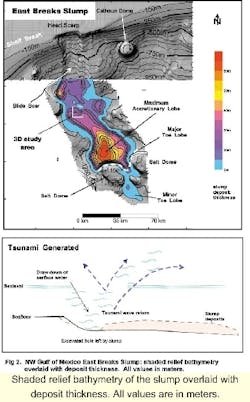
Rivers dumped massive loads of sediments and formed deltas at the shelf break. Rapid accumulations of sediments at the shelf's edge tend to be unstable and can lead to mass slope failure, assisted by gravity. Submarine slumps occurring in this manner can produce a tsunami. A tsunami is generated by the "draw-down" of sea level by the sudden removal of sediments at the seafloor.
Today, the occurrence of a mass slope failure at the present shelf edge could present a hazard to deepwater hydrocarbon production facilities, and the resulting tsunami could devastate coastal communities. The following article provides sufficient details to warrant an in-depth study of shelf edge mass movements to assess their occurrence and potential impact.
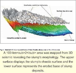
Three data sets were used to map the slump's area: multibeam bathymetry, regional 3D exploration seismic coverage by WesternGeco, and a full 3D data set. A 100-km2 area was mapped from full 3D seismic coverage to reveal finer details of the slump's morphology. Overall slump dimensions were determined by picking its top and base.
Occurrence
Occurrences of large shelf edge slumps are ubiquitous throughout the world. Typical examples include the Walker-Massingill slump in the eastern Gulf of Mexico and the Storegga slides offshore Norway. The East Breaks slump was first mapped in the 1960s with high-resolution seismic and core holes by the petroleum industry and subsequently surveyed by the US Geological Survey. The slump has a 60 km by 20 km erosional slump chute that extends 100 km downslope as accumulated debris.
In the late 1980s, when petroleum exploration and development extended into deep-water, mass gravity-induced flows were recognized as a potential risk to subsea facilities. The 3D seismic data acquired in conjunction with deepwater exploration activities provides an excellent tool for investigating slumps and other mass gravity flows. However, no detailed modern mapping or sampling programs have been undertaken and the East Breaks slump remains a mere curiosity.
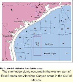
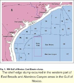
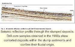
The East Breaks slump's eroded head scarp is located in the northwest corner of the Gulf of Mexico within the East Breaks and Alaminos Canyon Outer Continental Shelf (OCS) lease areas. Slumping originated within faulted deltaic deposits formed during sea level lowstand 10,000-20,000 years ago. Drill core samples obtained in the 1960s show contorted deposits within sediments and confirm their fluvial origin.
Slumps vs. flows
Marine slope failures can be categorized as either slumps or gravity flows. Slumps typically are a displaced semi-cohesive mass of sediments that accumulates as an accretionary lobe downslope of a failure zone called the head scarp. A toe lobe characterizes the farthest downslope reaches of a slump.
Gravity flows are similar to slumps, except that the displaced material tends to liquefy and flow down slope as mud or sand-rich turbidity currents. Most slope failures contain elements of both types of failure.
The East Breaks slump is oriented north to south and consists of a 20-km wide head scarp initiated along the 150-meter isobath at the shelf edge. The head scarp punctuates a 60-km long erosional chute. Sediments vacated from the chute piled up along a 100 km by 30 km accretionary lobe. The slump extends 160 km from the shelf edge out to a depth of 1,500 meters.
Two salt domes provided a barrier to southward movement or flow allowing only a thin lobe to pass between them and extend an additional 20 km downslope. Slumped deposits encompass an area of 3,200 km2 with a volume on the order of 50-60 km3. Compared to the Storegga slides, this slump is slightly smaller than the third most recent slide.
Slope failure
The initial failure took place on low angle slopes of less than two degrees while the present slump deposits have an average seafloor slope of one degree. Although the precise triggering mechanism that caused the slump is unknown, it was most probably the result of failure along relatively low slopes within loose unconsolidated faulted prodeltaic deposits. The area along the slump's failure zone is known to contain numerous faults that could have assisted its movement. One puzzling element of the slump is that it occurred on a very low angle slope within deposits that characterize most of the present shelf edge offshore Texas.
Extraction of the seafloor reflector from a 3D seismic cube covering a 100-km2 area within the central portion of the accumulated slump deposits reveals its extremely chaotic nature and intriguing relief and amplitude pattern. The seismic line shows the chaotic deposits overlaying undisturbed strata. Underlying horizons have been eroded by passage of the slump material where deposits are hummockier.
Seismic reflection amplitudes extracted from the seafloor reflector (top of slump) reveal a "worm-like" pattern that coincides with curved ridges several meters in height by 100 meters in width and 3 km long. Zones that display the highest density of ridges are interpreted as frictional drag folds caused by a reduction in velocity as the slump came to rest over slight topographic highs. A 3D display of the 100-km2 detailed study area is presented where the upper surface displays the slump's chaotic surface and the lower surface represents the eroded base of slump deposits.
Tsunami threat
Based on the slump's overall dimensions, a preliminary calculation of a tsunami created by the down draw would have generated a wave height on the order of 7.6 meters. A tsunami of this size would have traveled across the continental shelf and flooded the adjacent Texas coastline. Its run-up and debris should have left an imprint along the coast.
Tsunami deposits may be accessible for visual identification and used to chronicle the event. This kind of information should permit fine tuning of mathematical predictive models, assessing probability and frequency of such catastrophes, and verifying their accuracy.
The East Breaks slump represents a massive failure of the continental shelf. The slump is located in an area undergoing rapid offshore petroleum production and development. Should a slump of similar magnitude occur today, it would seriously impact the subsea facilities in its pathway.
The generation of a tsunami wave in conjunction with a slump could overrun inhabited coastal areas. Modern tools and data should be applied to assess past slump and tsunami frequency, and the impact such events could have on the northwestern Gulf of Mexico.
Acknowledgement
WesternGeco granted permission to publish the seismic section and maps extracted from the 3D seismic survey.
References
NOAA, 1993, Global Relief Data: GOM Multibeam Bathymetry; CD-ROM from National Geophysical Data Center, Boulder, Colorado.
Walker, J.; and Massingill, J., 1970, Slump Features on the Mississippi Fan, Northeastern Gulf of Mexico: Geological Society of America, Bul. V. 81, no. 10.
Jansen E.; Befring, S.; Brugge, T.; Eidvin, T.; Holtedahl, H.; and Sejrup, H.; 1987, Large Submarine Slides on the Norwegian Continental Margin: Sediments, Transport and Timing. Marine Geology, v.78.
Lehner, P., 1969, Salt Tectonics and Pleistocene Stratigraphy on Continental Slope of Northern Gulf of Mexico. AAPG Bul. V.53, no. 12, pp. 2431-2479.
Woodbury, H.; Spotts, J.; and Akers, W.; 1978, Continental Slope Sediments and Sedimentation; found in: Framework, Facies, and Oil-trapping Characteristics, Upper Continental Margin: Bouma, Moore and Coleman eds.; AAPG Studies in Geology No. 7.
Berryhill, H.; Suter, J.; and Hardin, N.; 1986, Late Quaternary Facies and Structure, Northern Gulf of Mexico. Interpretations from Seismic Data. AAPG Studies in Geology No. 23.
EEZ-SCAN 85 Scientific Staff, 1987, Atlas of the U.S. Exclusive Economic Zone, Gulf of Mexico: U.S. Geological Survey Miscellaneous Investigations Series I-1864-A, 104p.
Watkins, J., et al., 1996, Structural Framework of the Northern Gulf of Mexico; J.O. Jones and R.L. Freed eds., Special Publication of the Gulf Coast Association of Geological Societies.
