Accelerating geotechnical insights for offshore wind development in the Danish North Sea
Key highlights:
-
Fugro investigated 2,200 sq km of the Danish North Sea to support future offshore wind development.
-
Deepcone technology and advanced CPT systems improved subsurface characterization and investigation efficiency.
-
Offshore testing and reporting workflows helped deliver geotechnical insights earlier in the project lifecycle.
By A. Padwalkar, Fugro
Large offshore wind projects are often shaped by decisions made years before construction begins. That was certainly the case for the Danish North Sea development program. In 2022, Energinet, Denmark's national electricity and gas transmission system operator, commissioned Fugro to deliver a geotechnical investigation across a 2,200-sq-km area to support future offshore wind development.
The investigation aimed to support concession tender preparations and provide future developers with a better understanding of seabed and subsurface conditions. This geo-data informed foundation design, cable routing, installation planning and geohazard assessment, helping to ensure offshore structures are safe, stable and cost-effective throughout their lifecycle.
This extensive offshore site investigation program included 384 cone penetration tests (CPTs) and 112 boreholes across two offshore sub-areas. While the scale was significant, another challenge was how to provide meaningful geotechnical insight early enough to influence project planning.
Several initiatives were introduced to accelerate access to geotechnical insights, including an enhanced offshore laboratory, structured interim reporting and investigation methods designed to overcome difficult ground conditions. Together, these helped reduce the time between offshore acquisition and project decision-making.
Gathering better data, sooner
One challenge in accelerating access to geotechnical information is ensuring data can be collected efficiently across a wide range of ground conditions. In parts of the Danish North Sea program, dense soil layers limited the penetration achievable with conventional seabed CPT systems.
To overcome this, Fugro deployed its SEACALF MkV Deep Drive seabed system with Deepcone technology at selected locations, enabling deeper penetration through dense soil layers and achieving an additional 424 m of penetration across 41 CPTs. Seismic Deepcone investigations were also used to obtain deeper shear-wave velocity data and to strengthen the understanding of subsurface conditions.
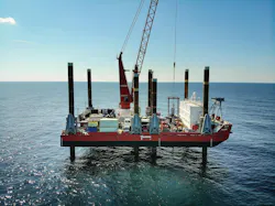
Part of the survey area was in shallow waters, presenting further operational challenges. To investigate these locations, Fugro mobilized the Fugro Excalibur jackup barge, which provided a stable elevated platform that enabled reliable operations and helped support consistent, high-quality sample acquisition.
By obtaining a more complete dataset during the initial geophysical, seismic and seafloor campaign, the team was able to optimize the subsequent borehole program, improving investigation efficiency and helping valuable geo-data reach project stakeholders sooner.
Closing the gap between acquisition and interpretation
Collecting offshore data is only one part of the process. Samples must still be logged, tested, interpreted and reported before findings can support project decisions.
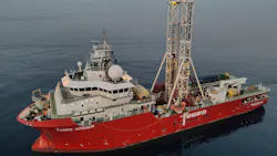
An enhanced offshore laboratory onboard Fugro Voyager enabled selected laboratory testing to begin immediately after sample recovery. Activities including particle size distribution, Atterberg limits, density and oedometer testing provided early insights into soil characteristics and behavior, allowing geological interpretation and laboratory program refinement to begin sooner than would typically be possible.
At the same time, a structured interim reporting program ensured key findings were delivered throughout the campaign rather than waiting for final reports, providing visibility of site conditions months before traditional reporting milestones.
Digital workflows further improved efficiency by reducing manual data handling and helping information move more quickly through the project lifecycle.
For developers and transmission operators, the greatest value often comes from having reliable geo-data available when critical decisions are being made, not months after those decisions have already been taken.
Designing investigations around project decisions
Large offshore wind developments will continue to demand extensive site investigations, but volume alone is unlikely to be the differentiator. The real challenge is ensuring that project data is available when stakeholders need it, helping to reduce uncertainty, avoid delays and support more cost-effective project development.
For the Energinet program, that meant thinking beyond offshore acquisition and considering how samples would be tested, interpreted and reported throughout the campaign. Earlier access to geotechnical findings helped support planning activities while the project was still evolving.
As offshore wind projects increase in size and complexity, the ability to move useful geo-data through the project lifecycle more efficiently may become just as important as the field investigations themselves.
About the Author
 A. Padwalkar
 A. Padwalkar
A. Padwalkar is Fugro's project director of Europe and Africa. He has more than 20 years of global experience across project management and commercial key account management, working in multiple roles at the company and leading high-profile projects in the offshore wind, renewables, and oil and gas energy sectors. Now based in the Netherlands, he leads a team of regional project managers to ensure projects meet financial, quality and client goals.