Trio concludes major 3D survey offshore Suriname
Offshore staff
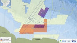
MASSY, France — A consortium of CGG, TGS and BGP have completed Phase IV of their deepwater 3D seismic survey offshore Suriname.
The 1,800 sq km covered was the final part of a program to acquire 14,500 sq km survey of new 3D data in deep and shallow water in the Guyana-Suriname Basin, with more than 6,400 sq km of existing data reprocessed.
Results will support Suriname’s future deepwater and shallow-water bid rounds.
Fast-track products from Phase IV will be available toward mid-year, with final products for the entire program accessible in late 2023.
03.21.2023
