Kyranis 3D project targets sharper imaging in Timor Sea
Offshore staff
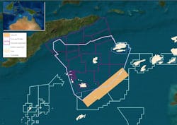
PERTH, Australia – TGS is reprocessing a multi-client seismic survey covering blocks offered in current exploration license rounds offshore Timor-Leste and Australia.
The 9,024-sq km (3,484-sq mi) Kyranis 3D survey, the company claimed, will provide 3D broadband PSDM imaging for the first time over an area recently re-opened for exploration following ratification of the two countries’ Maritime Boundary Treaty.
TGS expects to achieve improved uplift quality compared with the original PSTM data acquired in 2012, using imaging techniques such as full waveform imaging to support prospectivity evaluation.
Use of Broadband PSDM should also lead to better penetration and the removal of ghost signals for more accurate wavelet construction, improved coherent noise suppression, and more precise velocity modeling.
Will Ashby, executive vice president, Eastern Hemisphere, said: “We are confident that the application of our Broadband PSDM sequence will successfully overcome the challenges created by the complex seafloor in this region to create a sharper, more accurate image.”
Fast-track results should be available in 4Q 2021 followed by final deliverables in 2Q 2022.
04/12/2021