TGS details Africa, Brazil, Canada, North Sea survey targets
Offshore staff
ASKER, Norway – TGS has provided updates on its recent and current offshore seismic surveys.
Work continues on the company’s SeaSeep project over the MSGBC basin off northwest Africa.
The full program will cover an area of roughly 113,500 sq km (43,822 sq mi) and will incorporate around 230 cores from the seabed, positioned based on multibeam backscatter anomalies. Final results should be available next spring.
Acquisition of the Jaan 3D survey over the southern portion of the basin finished during 3Q. The project comprises 11,135 sq km (4,299 sq mi) of newly acquired data and reprocessing/full pre-stack merging of existing multi-client 3D data.
The BGP Prospector is in the same region acquiring over 4,500 sq km (1,737 sq mi) of 3D data for the multi-client Senegal Ultra-Deep offshore 3D survey, supported by Petrosen. GeoPartners is the other co-venturer: TGS expects to issue fasttrack data in early 2Q 2020.
In the Egyptian Red Sea, TGS, in collaboration with WesternGeco, completed reprocessing of 3,600 sq km (1,390 sq mi) of 3D seismic data for the country’s Red Sea international license round, staged in September.
Also completed during 3Q was the Brazil Southern Basins SeaSeep project, spanning over 210,000 sq km (81,081 sq mi) across the Campos and Santos basins.
Acquisition continues of the expanded 22,500-sq km (8,687-sq mi) Santos multi-client 3D project over the southern Santos basin.
Elsewhere off Brazil, acquisition has finished of the 10,350-sq km (3,996-sq mi) Potiguar multi-client 3D seismic survey, with final data due to be released next summer.
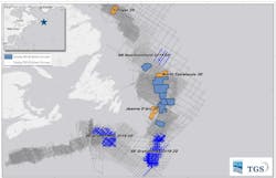
Offshore East Canada, TGS, under a joint venture with PGS, completed acquisition of 3D projects that included the 4,165-sq km (1,608-sq mi) Jeanne d’Arc survey, the 4,608-sq km (1,779-sq mi) North Tablelands survey, and the 3,699-sq km (1,428-sq mi) Torngat survey.
2D projects include the 10,519-km (6,536-mi) Southeast Grand Banks survey and the 576-km (358-mi) Northeast Newfoundland Slope 2019 2D survey. Final data for all the projects should be available during 2Q 2020.
In the Norwegian North Sea, the TGS/AGS venture continued acquiring the Utsira ocean bottom node survey. Work has finished on the 5,950-sq km (2,297-sq mi) Atlantic Margin multi-client 3D survey in the Norwegian Sea, while acquisition started on the 5,151-sq km (1,989-sq mi) Greater Castberg 2019 multi-client TopSeis 3D project in the Barents Sea, in collaboration with CGG.
In the UK southern North Sea, TGS completed acquisition of the 1,332-sq km (514-sq mi) UK SNS-3D multi-client survey.
11/04/2019
