Real-time borehole seismic runs on drillpipe connection schedules
By Marwan Moufarrej & Jim Thompson, Schlumberger
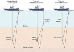
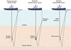
A recently developed technique generates conventional borehole seismic measure-ments in real time while a well is being drilled. The device uses a logging-while-drilling (LWD) tool with seismic sensors located near the drill bit, a seismic source at the surface, and a measurement-while-drilling (MWD) tool for real-time telemetry.
The technique has proven successful in field tests performed worldwide. During one seven-well test campaign conducted in two deepwater Gulf of Mexico fields, seismic check-shot information was successfully acquired without disrupting the normal drilling operations underway at the time.
Real-time seismic information captured from MWD telemetry is used to update seismic sections, marker locations, and target position estimates. Updated seismic sections can be used to more accurately and effectively navigate a well's path, select coring and casing points, and avoid drilling hazards. In this and many other field applications, having seismic measurements available in real time has helped improve drilling efficiency and safety, as well as reducing the risk and cost of drilling and constructing wells.
Drilling performance
A process-driven approach to drilling challenging wells, developed by BP and Schlumberger, has been demonstrated to greatly improve drilling performance from economic, operational, and technical standpoints. The "no-drilling-surprises" process begins with a planning period, during which a detailed pre-drill well plan is generated. While this well plan is based on the best information available at the time, much of it comes from estimates, correlations, and predictions. Thus, it is impossible during the pre-drill phase to eliminate all of the risks inherent to drilling in challenging environments.
Taking this into account, a pre-drill plan includes provisions for predicting potential hazards and developing contingencies for dealing with them. It also includes a strategy for acquiring data while drilling, which are immediately used to make important decisions and continually update the plan. This transforms a static plan into a dynamic one that accounts for, and even anticipates, differences from predictions.
The process focuses on the acquisition of relevant information in the required time frame, which varies depending on the stage of the well or the distance to a particular target. Also, the type of information acquired affects whether it is relevant throughout a particular time frame.
For example, while an interpreted seismic section in the time domain usually remains valid throughout a drilling project, its travel-time-to-depth conversions may vary. Borehole seismic measurements can be used to convert travel-time-to-depth, and are increasingly being included in real-time information gathering efforts to reduce the uncertainty present when drilling ahead.
Reducing uncertainty
The surface seismic section, which shows general features of the subsurface, often is used to determine the drilling target location. However, travel-time interpretations of subsurface reflectors, which are measured in milliseconds (msec) and form the basis of the surface seismic section, often have no corresponding depths available, particularly when exploring new prospects. Converting travel-times to depths can be complicated, requiring sound velocity information about each rock type encountered from the surface to the target. This is usually not directly available, but must be assumed using data from analogous basins.
Still, this data must be used to make important drilling decisions, such as casing point selections. Before a well is drilled, uncertainty regarding its casing point locations may be high, often in the hundreds of meters. Uncertainty increases drilling risk, but this risk can be reduced in more mature basins for which marker beds have been established using drilled cuttings or LWD responses from nearby wells. In new basins, however, other methods must be used to locate the drill bit on the seismic section or driller's map.
Borehole seismic has been used to accomplish this, supplying the needed information in the form of check-shot (time/depth) data. Check-shot data is used to convert seismic travel-times to depths, thus providing a direct link between the driller's map and the bit location. Check shots measure the time it takes for a seismic wave to travel from its source to the receiving tool. They are used to place the bit on the seismic map, helping to navigate the well path, select casing and coring points, and avoid drilling hazards. A result of improved knowledge of the bit's location might be an eliminated casing point, or in some cases, an additional one to mitigate risk.
Conventional methods
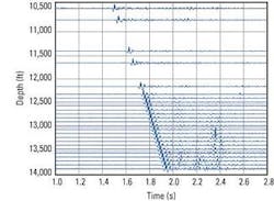
In the past, two methods have been available to acquire borehole seismic data. Intermediate (between drilling runs) vertical seismic profiles (VSPs) are generated by borehole seismic measurements using a wireline-conveyed tool that receives a seismic source activated from the surface. VSPs in the form of stacked waveform data include the basic check-shot (time/depth) measurements needed to place the bit on the seismic map. Although wireline borehole seismic tools provide high-quality data, their use requires that drilling be interrupted, causing rig time, costs, and risks to mount.
Furthermore, if a wireline run were to be scheduled too early or late, the casing point or drilling hazard already would have been encountered. So while wireline seismic surveys provide high-quality data suited for reservoir characterization studies, they lack the benefits that are realized when real-time information is acquired during drilling.
Seismic-while-drilling (SWD) techniques generate borehole seismic measurements in real time. When drilling ahead, real-time seismic information is instrumental in alerting the rig crew to potential drilling hazards, thus reducing uncertainty and risk. The timely information also allows offsite geoscientists to update interpretations and gain improved understanding of the underlying reservoir.
In addition to optimizing processes and reducing risks, real-time borehole seismic helps operators save on drilling and well construction costs by helping them avoid hazards or additional casing strings, as stated previously. Additionally, generating check shots while drilling can significantly reduce costs by eliminating the rig time needed for the wireline job. The real-time information that they provide also helps eliminate potential sidetrack costs by placing the well more precisely with respect to an event on the surface seismic.
For several years now, real-time check shots have been conducted while drilling using noise generated by the bit. Drillbit noise served as the seismic source, generating waves that were recorded by surface receivers. However, while drillbit SWD was effective in generating real-time seismic information in some environments, it was ineffective when applied in soft formations or high-angle holes, and when a polycrystalline diamond compact bit was required.
New technique
The SeismicMWD™ technique provides basic real-time check-shot information throughout a wide range of environments, while requiring little or no additional rig time, thus overcoming the shortcomings of the drillbit SWD and wireline check shots. The system consists of a conventional seismic source with control equipment at the surface, as well as a bottomhole assembly (BHA) downhole that includes both an LWD tool with seismic sensors and an MWD system for real-time telemetry.
A conventional source such as an air gun produces the seismic energy at the surface. For offshore operations, this source is mounted on a rig for vertical or slightly deviated wells. Horizontal or highly deviated wells require that the source be deployed from a boat. The seismic energy is received downhole by the LWD tool, which consists of seismic sensors, a processor and memory. In turn, it communicates with the MWD mud-pulse telemetry system. The recording schedule and acquisition parameters are configured into the tool.
Borehole seismic surveys can be sensitive to the noise that normal drilling activities generate. Therefore, the source is activated and data acquired during trips or drilling pauses. That is, the seismic source is fired during the quiet time when the drillstring is stationary and the mud is not circulating, usually before or after a new stand of pipe is connected. Since the measurements are planned around pipe connection schedules, a check shot is produced without spending additional time and interfering with drilling functions. During the normal time required to make a connection, several readings can be taken at 10- or 15-second intervals.
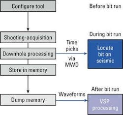
The seismic source is activated during the bit run while the tool is at selected depths. Following source activation, the data is processed and results such as time-pick information and quality indicators are computed. The one-way travel-time, or check shot, is telemetered uphole as soon as the mud pumps resume. Check-shot data obtained at each connection point, or more frequently if required, determine the bit location. At the surface, proper depths are assigned to the real-time data and the time-depth pairs are used to locate the bit on the surface seismic section, providing a direct tie of the bit location to transit time. Knowing in real time the bit position relative to seismic markers and target total depth locations helps predict the distance to the next drilling objective or hazard, reducing uncertainty as the wellbore approaches a casing point or target depth.
Application
One of the areas this tool has been applied is in the deepwater Gulf of Mexico, where a prototype was run in seven wells drilled in two adjacent, 3,400-ft deep fields. Along with the new tool, MWD, resistivity, sonic and density-neutron tools were run. Incorporated in one BHA, the new system was designed to transmit seismic data without interfering or slowing LWD data transmission.
Making up the seismic source were three 150 cu in. air guns that were charged to 2,000 psi and mounted on the side of the rig. During the normal pauses of tripping and drilling operations, when connecting or disconnecting drillpipe, the surface source was activated and data were acquired downhole. Typically at each connection, 10 shots were fired and data were recorded into tool memory. Since shooting was completed by the time drillpipe was removed or returned to the rack, borehole seismic was acquired without disrupting rig operations. Time-pick data and quality indicators were retrieved automatically from the tool when mud was circulated while drilling ahead.
Check-shot data were successfully transferred uphole and retrieved at surface while the tool remained in the well. Slightly modifying downhole algorithms between runs steadily improved check-shot recovery success rate, which reached almost 90% in one of the later tests. Comparing both time-pick methods, automatically by the tool and manually on the recorded waveforms, showed only small differences, normally within 4 msec. In later projects, this accuracy improved to 2 msec. In fact, the accuracy and reliability of the real-time data enabled important decisions regarding well placement to be made.
Future plans
While check-shot data can be transferred uphole in real time, waveform data must be stored until the assembly is brought to surface. After the bit run, waveform data stored in downhole memory is retrieved at surface for VSP processing. Although current MWD telemetry speeds prohibit the timely transmission of full seismic waveforms, developments currently are underway to overcome these limitations, thus allowing a VSP to be generated in real time.
Other borehole seismic applications also exist with real-time VSPs, which include predicting pore pressures and imaging the formation ahead of the bit. Look-ahead images are formed from seismic reflections of horizons in front of the bit, giving drillers the ability to see what lies ahead of the drill bit. Real-time seismic velocities also can be used to update pore-pressure predictions from surface seismic. Ultimately, these data will be combined with look-ahead images to provide a direct measurement of the distance to a marker of interest.
Acknowledgment
The authors thank Shell Exploration and Production Company for the field applications used in this article.
References
Underhill, W., Esmersoy, C., Hawthorn, A., Hashem, M., Hendrickson, J. and Scheibel, J.: "Demonstrations of Real-Time Borehole Seismic From an LWD Tool," paper SPE 71365, presented at the 2001 SPE Annual Conference, New Orleans, LA, USA, Sept. 30-Oct. 3.
Bratton, T., Edwards, S., Fuller, J., Murphy, L., Goraya, S., Harrold, T., Holt, J., Lechner, J., Nicholson, H., Standifird, W. and Wright, B.: "Avoiding Drilling Problems," Oilfield Review 13, no. 2 (Summer 2001): 33-51.
Esmersoy, C., Underhill, W., and Hawthorn, A.: "Seismic Measurement While Drilling: Conventional Borehole Seismics on LWD," SPWLA 42nd Annual Logging Symposium, Houston, Texas, (2001).


