P.2 ~ BP applies novel seismic survey offshore Trinidad

View Article as Single page
The ISS acquisition technique was tested on a North Sea field. By taking the acquisition to the ocean bottom, leverage increased for getting more data with more efficiency. The test showed the need for still more data density, and that came with very dense sampling of receivers. OBC gives freedom of source points. Ocean-bottom nodes are pressurized cylinders that hold recording equipment. Shooting vessels can travel almost anywhere they want, depending upon surface infrastructure. That is improved, even, without the necessity to tow streamers. With this method, the limits are set by the number of ocean-bottom receivers available and the speed with which the source vessels can travel the assigned grids.
BP did a test run of the ISS data collection method in the North Sea at the Macar field, and that testing showed that the technique would work in getting higher-quality data sets faster and cheaper than with traditional means. The company shot one patch of data in the North Sea two times, once using single-source wide-azimuth acquisition and once using ISS with two source vessels. The results were nearly identical.
BP's biggest use of ISS so far came in Trinidad where the company operates a very large production license. BP decided it was worth the effort to determine if there was any remaining production potential. The existing seismic data was vintage late 1990s and consisted of towed-stream, narrow-azimuth returns. That was sufficient for the early development of the Trinidad fields, but more than a decade later the company wanted a finer degree of resolution and much greater detail. The Trinidad holdings have several fields with multiple stack reservoirs and from a seismic perspective can be treated as one big, highly complex field.
In addition to size, Trinidad has roughly a six-month shooting season due to environmental, weather, and regulatory concerns. That meant that to cover the required area would take upward of 700 days, and that was too long. The area to be covered also had a lot of infrastructure that would make it extremely difficult to conduct a towed-streamer survey.
To get high-density, high-quality data within a reasonable time and at a reasonable cost, BP brought in the idea of marine ISS coverage.
BP used the same crews in Trinidad that had performed the North Sea tests, so the personnel were familiar with the process. For efficient contracting, BP entered a two-year agreement with WesternGeco for vessels in the North Sea over the summers of 2011 to 2013, and to use the same crews in Trinidad during the intervening winter months. Working continuously with the same two vessels, sharing learnings between the two regions, and increasing the length of cables used helped both operational and HSE performance. Compared to the first season, the second season increased acquisition efficiency by 45% with a corresponding reduction in cost per square kilometer of 22%.
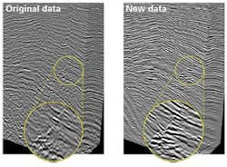
In Trinidad's multiple stacked reservoirs, gas-saturated sand tends to slow sound transition, and the seismic waves tend to distort to the point that the shallow pay masks the deeper pay. The Columbus basin seismic survey was designed to progress resources and to discover new prospects in existing and future major gas fields. The 1,000-sq km (386-sq mi) high-density, 3D, ocean-bottom sensor program was the first commercial use of the ISS technology with seabed acquisition.
Editor's note: This article was the result of interviews with John Etgen, distinguished advisor for advanced seismic imaging, and Raymond Abma, senior research geophysicist, for BP.