Four play types identified offshore southern Argentina
Steve DeVito, Neil Hodgson, Karyna Rodriguez
Spectrum Geo
Argentina’s government recently announced plans to open the offshore West Malvinas basin for leasing to qualified operators, starting with an official license round launch scheduled for last month and closing in late-November 2018. In conjunction with this program, Spectrum has undertaken new state-of-the-art 2D seismic data acquisition and processing, designed to illuminate the oil and gas potential of this large frontier basin. It is an overlooked area, separated from a major producing basin by a structural arch and lying in shallow to moderate water depths, but receiving renewed attention from E&P companies.
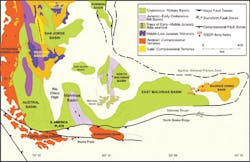
The Austral and Malvinas basins regional setting (Vayssaire, 2012).
(All images courtesy Spectrum Geo)
Regional setting and geology
The West Malvinas basin is in the southern Atlantic Ocean, 80-100 km (50-62 mi) offshore Tierra del Fuego in southernmost Argentina. Only 20 exploratory wells have been drilled in the basin, which extends over an area of more than 100,000 sq km (38,610 sq mi) with up to 12,000 m (39,370 ft) of sedimentary section preserved. Water depths range from 50-500 m (164-1,640 ft), with the majority of the basin in less than 100 m (328 ft). More than 7 Bboe of recoverable reserves have been discovered in the neighboring Austral basin, where oil and gas production has been ongoing since the 1950s onshore and since the 1970s in coastal Atlantic waters. Although there has been no commercial production in the West Malvinas basin, a proven petroleum system has been documented and multiple new and established play types remain to be explored.
The Austral and West Malvinas basins share a similar evolutionary history and stratigraphy, having developed during the breakup of Gondwana and the formation of the Atlantic Ocean in the Mesozoic era. They are separated by the Dungeness Arch (also known as the Rio Chico High), an elongate NNW trending basement high which is the offshore extension of the Deseado Massif and which also separates the Austral from the San Jorge basin, another important oil and gas producing region, to the north.
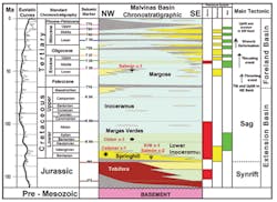
Offshore Austral and West Malvinas basins stratigraphic column
(after Vayssaire, 2012).
Both the Austral and the West Malvinas basins host a proven petroleum system -- the Lower Cretaceous Springhill Formation sandstone reservoir and the Lower Inoceramus hydrocarbon source rock and seal, immediately overlying the Springhill. Most of the exploratory wells in the area to date were drilled in the early 1980s, targeting the Springhill-Lower Inoceramus play in faulted or anticlinal structural highs. A second, less extensive phase of drilling followed in the mid-late 1990s, again targeting the Springhill play.
Oil and gas production offshore Argentina has so far been limited to the eastern flank of the Austral basin where multiple commercial oil and gas discoveries have been made in the Springhill. This is the reservoir that accounts for more than 95% of the oil and gas produced to date. Although only five non-commercial discoveries have been made in the analogous play in the West Malvinas basin, all demonstrated the presence of an active petroleum system in this basin.
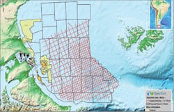
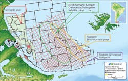
The 2017-2018 Spectrum multi-client seismic survey in red with proposed lease blocks superimposed.
Spectrum 2017-2018 multi-client seismic survey
Beginning in the fall of 2017 and concluding in March 2018, Spectrum acquired 13,784 line km (8,565 mi) of long-offset 2D seismic data over the West Malvinas basin using the BGP vessel Pioneer SV. The new acquisition specs, which included a 12,000-m (39,370-ft) long geophone streamer, a 12.5-m (41-ft) group interval and a 25-m (82-ft) shot point interval, delivered far superior imaging of the deep sedimentary section in the basin than the 1980s vintage seismic which employed 3,000-3,500 m (9,842-11,483 ft) long streamers, not optimal for imaging below 3,000 m. While recent reprocessing of the legacy data has improved shallow data quality, it has not significantly improved imaging below 3,000 m.
One example of how the new survey is adding to our understanding of the basin architecture and sedimentary fill is that it is now possible to identify parts of the basin where as much as 12,000 m (39,370 ft) of sediments are present; the deepest part of the basin was previously thought to be about 7,000 m (22,966 ft) thick. This has important implications for the thermal maturity of source rocks and the generation and migration of hydrocarbons. Also, prospective syn-rift grabens can clearly be seen below the Springhill, opening the possibility of new plays in the deeper syn-rift section. The much-improved resolution of the new seismic allows reliable mapping of the Springhill reservoir itself, which was not possible on the legacy seismic.
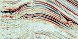
Large structures with depth conformant stacked amplitude anomalies. The image indicates phase change for some of the amplitudes with an apparent reduction in frequency in the sequence immediately below. Indications of brightening in the far angle stack.
Broadband processing is designed to preserve low frequency signal content and improve data resolution and bandwidth leading to more robust velocity analysis and more accurate AVO analysis. Broadband PSTM and PSDM (pre-stack time migration/depth migration) combined with angle stacks and gathers will support better quantitative analysis of Spectrum’s new data set, which recently underwent processing at DownUnder GeoSolutions’ Houston center. Austin Bridgeporth acquired and processed the accompanying shipborne gravity and magnetics data.
Prospective plays
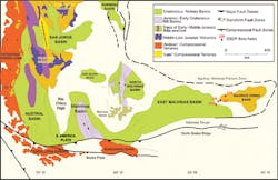
There appears to be four main play types for the West Malvinas basin based on a review of historic literature, Spectrum’s new long-offset seismic data, and past drilling history. The proven Springhill sandstone play of the Austral basin is present east and south of the Dungeness Arch. An Upper Cretaceous/Lower Tertiary turbidite sandstone play coincides with an Upper Jurassic Syn-rift play in the east-central part of the basin, presenting numerous amplitude anomalies associated with large structural traps with conformance to structure. There are also multiple fluid escape features at various stratigraphic levels indicating the presence of an active hydrocarbon source in that area.
Generalized play fairways, offshore Austral and Malvinas basins.
In addition, Spectrum has identified a South Malvinas Foldbelt/Foredeep play along the southern margin of the basin, analogous to the Darwin discovery in the offshore South Falklands basin to the east, and a foreland stratigraphic/structural play in the eastern updip segment of the foreland. To sum up, modern seismic data has revealed significant untapped potential in multiple proven and new play types that are ready be to properly explored in this exciting frontier basin.
Seismic data example
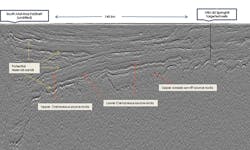
The image shown here is an example of the 2017-2018 Spectrum seismic survey. The display is a highly compressed PSTM Pseudo-relief section, roughly 200 km (124 mi) long, oriented northwest-southeast. On the northwest end of the line (on the right) is the structural style of the Springhill play where most drilling to date has taken place.
A PSTM (pre-stack time migration) line from the 2017-2018 Spectrum survey demonstrating basin architecture and prospectivity.
On the southeast (left) end of the line is the undrilled South Malvinas Foldbelt, 140 km (87 mi) away. Notable features of this line are the high-resolution expression of sand development (high amplitude ‘soft’ events) within a largely shale/claystone sedimentary section; the sharp definition of syn-rift faults in the deeper section; and the now mappable base of syn-rift section below the Springhill. Numerous leads and prospects can be identified throughout this very large undrilled area.
