DEEPWATER E&P: Autonomous underwater vehicle surveying pipelines, subsea installations
Jay Northcutt
C & C Technologies, Inc.
New designs show autonomous under-water vehicles (AUVs) can perform critical deepwater survey work for exploration and production (E&P) operations. These vehicles are versatile and reliable enough to offer advantages over traditional towed methods for performing such work.
Offshore E&P companies require comprehensive, high-resolution geophysical surveys to support the engineering and development of underwater facilities. The results of these surveys show detailed bottom topography, surface features such as boulders, outcrops, debris, pockmarks, drag marks, and gas vents, as well as subbottom features such as faults, shallow gas pockets, and sediment structure.
To obtain this information, the geophysical survey must collect multibeam echosounder data, side scan sonar data, and subbottom profiler data. The combination of these data sets helps to define the ocean bottom and subbottom. However, acquisition of good data, particularly in deepwater, has historically been challenging.
AUVs to the rescue
An AUV is a self propelled, unmanned underwater vehicle controlled by an onboard computer. Unlike a towed sonar or remotely operated vehicle (ROV), it has no umbilical. Over the last decade, several AUV prototypes have been designed and tested. These AUVs have been designed for a variety of functions, including mine hunting, water sampling, and surveying
Some AUVs are designed to hover. Others are designed to be streamlined cruisers. The AUV designs come in a variety of shapes from as long as 10 meters to as short as a meter. Some AUVs are built around a single sensor, while others are built to support one of a variety of sensors.
If properly designed, an AUV could perform a deepwater pipeline or subsea installation survey much faster and more accurately than conventional survey techniques. Working with BP, C&C Technologies of Lafayette, Louisiana, has constructed a deepwater AUV with all the critical sensors, including a multibeam, a sidescan, and a subbottom profiler.
Hugin 3000
C&C's Hugin 3000 AUV was built in conjunction with Kongsberg Simrad and is specifically designed to perform deepwater oil and gas geophysical surveys. After eight months of construction and another nine months of sea trials, this third-generation system became operational in January.
Since then, the Hugin 3000 (for 3,000 meters or 10,000 ft) has been used on several large projects in the Gulf of Mexico including Mad Dog, Crazy Horse, Holstein, and Na Kika. The AUV is rated for 10,000 ft and includes 200 kHz multibeam bathymetry and imagery, dual frequency sidescan (120 kHz and 410 kHz), and a subbottom profiler (2-10 kHz).
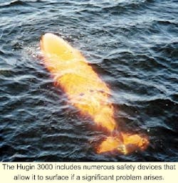
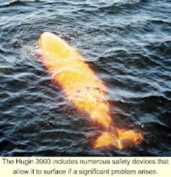
An aluminum oxygen fuel cell and ni-cad back up batteries power this AUV. With the fuel cell power source, the AUV can travel at 4 knots for at least 40 hours while running all of its sensors. The Hugin 3000 is 17 ft long and has a diameter of 3.3 ft. It includes numerous safety devices that allow it to surface if a significant problem arises.
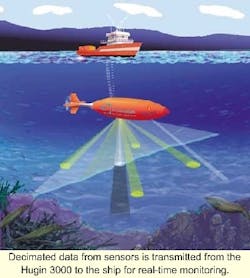
Survey lines and sensor settings can be pre-programmed into the AUV before it is launched, or, the survey program and sensor settings can be altered via an acoustic telemetry link while the AUV is in use. Multibeam, sidescan, subbottom, and positioning data are recorded in the AUV.
Decimated data from these sensors is transmitted from the AUV to the ship for real-time monitoring. If the ocean bottom terrain is not conducive to facility installation, the current survey line can be aborted and the AUV reprogrammed in real time, to survey a different area.
AUV positioning
In depths less than about 800 meters, a conventional deep-towed sonar can be acoustically positioned from the tow vessel. However, in greater depths, this method is no longer viable. Alternatives, such as deploying a long baseline (LBL) array or using a second vessel, sometimes called a chase boat, to position the towfish are employed. Of these two methods, the chase boat technique is more cost effective.
If the same operation were performed using an AUV, only one vessel would be needed. That one vessel, the AUVs mother ship, can transit over the AUV just as a chase boat tracks over a towfish. AUV positioning is achieved using a USBL acoustic positioning system integrated with an inertial navigation system, a Doppler velocity log, and a fiber-optic gyro.
Survey time
The Hugin 3000 requires less survey time than conventional towed systems. It does this in two ways:
- The survey speed of the AUV is much higher than a deep-towed sonar. A deep-towed fish is limited to about 2.5 knots. That is because at high speeds, the towfish tends to rise too far from the bottom to get good data. Alternatively, the AUV routinely travels at 4 knots, about 60% faster than a deep tow.
- Line turns take far less time for an AUV than a deep-towed sonar. For example, deep-tow systems take 2-6 hours to make a 180-degree turn. These long, wide turns prevent the towfish from colliding with the ocean bottom. Historically, up to half the time spent on a deep-tow project is used for line turns. This AUV can make a line turn in just a few minutes. In fact, the AUV can usually end a survey line, turn and be on the next survey line faster than the survey ship itself.
Survey data
One of the difficulties of using a deep-towed sonar is getting on and staying on the survey line. Currents can push the towfish off line by hundreds of meters, depending on the tow vessel's speed direction, and current conditions. If a target is missed, it usually means a long slow turn in the hope that the current/boat speed effect is understood well enough from the opposite direction to move the vessel relatively close to the target. By contrast, the AUV may crab a bit to overcome the currents; however' it will stay within a few meters of the proposed survey line.
The survey itself is improved by the AUV's ability to maintain a constant distance from the ocean bottom. This is difficult for a deep tow, especially in rough terrain. If the deep tow is too high, data quality will be poor. If the deep tow is too low, cross track coverage is limited, and the possibility of colliding with the bottom increases. Also, if the deep tow has a multibeam sonar, varying towfish height results in data holidays between lines. These are time consuming to fill.
An AUV can work close to obstructions where tethered systems could become tangled. Deep-towed systems cannot operate close to structures with anchor cables, such as anchor rigs, anchor barges, moored boats, or platforms.
The AUV uses two 50-gigabyte hard drives to record sensor and positioning data. Once the AUV returns to the survey ship, about once every 40 hours, the raw data is downloaded over a 100 baseT Ethernet. Full data sets are then used to produce finished survey charts and reports onboard the survey ship. A high-speed Inmarsat terminal transmits these finished products to C & C's office where they are transferred by secure Internet website.
Launch and retrieval
The launch and recovery system of the Hugin 3000 is built into a standard 20-ft shipping container. The container can be secured to the stern of the survey ship. To retrieve the system, the AUV is brought to the surface and commanded to release its positively buoyant nose cone. The cone is connected to the AUV by a 10-meter floating rope. The vessel fires a grapnel loaded into a harpoon gun over this floating line. The grapnel is tied to a retrieval winch and used to reel in the AUV. This procedure works well in up to 5-meter seas and does not require personnel to leave the ship.
From a capital standpoint, an AUV is far more expensive than a deep-towed sonar system, but its speed and accuracy allow it to be more cost effective to operate. Generally, in water depths greater than about 500 meters, the AUV becomes more cost effective than a deep-towed system. Project time with the AUV is often one-third of that required for conventional survey equipment, and the data quality is far superior.


