Beyond GNSS: subsea positioning technologies as a resilient navigation reference for offshore operations
Key Highlights
- In GNSS-denied environments, offshore vessels need independent position references to maintain trusted navigation and mission continuity.
- Georeferenced seabed transponders provide a position reference independent of live satellite signals, while acoustic and inertial technologies determine the vessel’s position relative to them.
- This underwater positioning reference strengthens navigation resilience when GNSS is degraded or unavailable, helping reduce the risk of disruption during critical offshore operations.
GNSS remains the backbone of offshore navigation. Yet growing concerns over jamming, spoofing and signal interference are highlighting the risks of relying on a single positioning source. As offshore projects become more complex and operational downtime more costly, operators are increasingly looking for complementary solutions capable of maintaining trusted positioning when GNSS performance becomes uncertain. One of the most promising alternatives may already be located beneath the vessel itself.
Looking below instead of above
When discussing alternatives to GNSS, the focus is often placed on additional sensors or new satellite-based capabilities. Yet many offshore operations already deploy a valuable positioning infrastructure on the seabed itself.
Acoustic transponders are routinely used to position underwater assets such as ROVs and AUVs. Once georeferenced — typically during an initial ROV boxin calibration — these transponders create a network of known reference points on the seafloor.
What matters here is that this reference, once established, becomes independent of any live satellite signal. And it can serve more than underwater vehicles: the same seabed network can also support the navigation of the surface vessel operating above it. Combined with Exail's Gaps USBL acoustic-inertial positioning system, it becomes an independent source of positioning information that complements traditional satellite navigation.
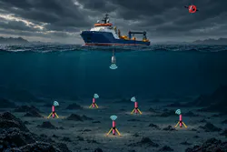
A network of georeferenced seabed transponders, combined with Exail’s acoustic-inertial positioning technology, creates a common positioning framework for surface vessels, ROVs and AUVs. ©Exail
Combining acoustic positioning and inertial navigation
Turning seabed references into a navigation aid for surface vessels requires more than acoustic measurements alone. Exail's Gaps system combines acoustic positioning capabilities with a high-end inertial navigation system in a single, pre-calibrated housing. As the vessel interrogates the seabed transponders, acoustic measurements are fused with onboard inertial data.
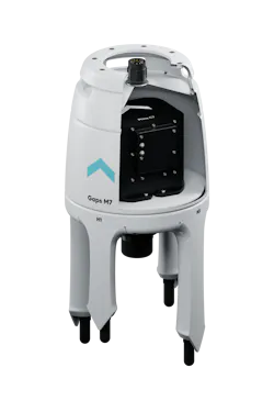
By combining acoustic measurements from seabed transponders with embedded inertial navigation, Exail's Gaps system provides a position reference independent of satellite signals. ©Exail
The embedded inertial system, built on fiber-optic gyro (FOG) technology, continuously computes the vessel's motion, while the transponder network provides external references tied to known locations on the seabed. By combining these complementary sources of information, Gaps delivers a robust positioning solution that remains available even when satellite signals are degraded or unavailable. For deepwater operations, positioning accuracy can remain below 5 m at depths of up to 3,000 m, depending on the transponder network configuration.
Supporting high-precision offshore operations
The combination of inertial navigation and seabed references can support a wide range of offshore activities where positioning performance directly impacts execution: offshore construction, cable and pipeline installation, subsea intervention, infrastructure inspection and hydrographic surveys.
For DP vessels, Gaps interfaces with major dynamic positioning systems and feeds them an absolute position derived from the reference positions of seabed acoustic transponders. The embedded INS continuously computes the position of the acoustic head relative to the georeferenced transponder network, independently of satellite signals. This gives the DP controller a position reference that is physically independent of GNSS, strengthening the position-reference redundancy that vessel operators and charterers increasingly expect. By leveraging the same seabed network used for underwater positioning, surface and subsea assets can share a single navigation framework across multiple project phases.
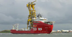
Offshore operations increasingly rely on independent position references to maintain navigation resilience when GNSS signals are degraded or unavailable. (Skandi Açu. Photo: Kees Torn / Flickr. Licensed under CC BY-SA 2.0.)
Operational benefits beyond navigation
Beyond the technical aspects, the approach offers tangible operational advantages.
- Continuity. Relying on more than one positioning source reduces exposure to GNSS interference and helps avoid unplanned interruptions during critical activities such as cable installation or inspection campaigns, where delays quickly translate into additional costs.
- One network, several functions. A transponder network installed to support ROV or AUV operations also contributes to vessel navigation. Surface and subsea assets then operate within a common positioning framework, simplifying coordination and increasing confidence in navigation data from one phase to the next.
- Flexibility. Operators can use transponder networks already on the seabed or deploy a dedicated reference array sized to the mission. With its open architecture, Gaps is compatible with Exail and third-party transponders, so existing investments can be built upon rather than replaced.
A complement to GNSS
For offshore operators, the objective is not to replace GNSS. It is to ensure that positioning remains available, trusted and operational throughout the mission. In an environment where navigation performance directly impacts project execution and cost, the most valuable backup may not require looking to the sky — but to the seabed beneath the vessel.
Sponsored by:

Related