ConocoPhillips planning multi-well campaign in offshore Otway Basin
Offshore staff
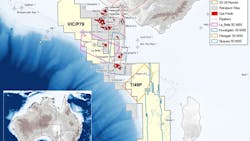
MELBOURNE, Australia — 3D Oil has issued an update on ConocoPhillips Australia’s drilling plans for exploration permits VIC/P79 and T/49P in the Otway Basin offshore Victoria and King Island, Tasmania.
The goal is to prove up commercially viable natural gas reserves to meet local domestic demand. 3D Oil has a 20% interest in both permits.
The co-venturers plan seabed surveys and drilling of up to six exploration wells. At the same time, ConocoPhillips has started work on preparing an environment plan to secure approval for the campaign.
Currently various subsurface activities are taking place, designed to help inform potential drilling locations. Reprocessing of the La Bella 3D seismic survey in VIC/P79 should provide an uplift in image quality over key leads downdip of the La Bella discovery, 3D Oil added, including Rosetta and Monarch.
Here, channeling in the overburden has impacted image quality and discernment of amplitudes (commonly associated with gas discoveries in the basin). Reprocessing should also improve image quality over the Essington (ex-Vanguard) prospect, satisfying one of the main work commitments of the permit’s three-year primary term.
And the co-venturers are assessing options for a multiclient seismic survey in the Otway Basin. The work program for VIC/P79 calls for acquisition of 1,000 sq km of 3D seismic in the secondary term (year 5), as there is currently no 3D seismic over the northern part of the permit. The Regia survey should improve understanding of the area’s prospectivity.
Processing is nearing completion of the Sequoia 3D marine seismic survey and should deliver a high-resolution image over all leads within the central and southern areas of T/49P.
ConocoPhillips has in addition reprocessed 974 sq km of the 2015 Flanagan 3D seismic survey, covering the Flanagan prospect in the north, in parallel with the Sequoia 3D program, to create a blended continuous volume across the permit. Interpretation of the blended dataset is ongoing and should assist identification of a basinwide portfolio of drillable prospects.
06.01.2023
