Mauritius, Seychelles to license joint offshore area
Offshore staff
WOKING, UK – The Joint Commission of the Mauritius-Seychelles Extended Continental Shelf, Mascarene Plateau region has opened the two states’ joint management area (JMA) for oil and gas exploration.
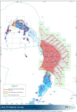
The JMA covers an area of around 400,000 sq km (154,441 sq mi) in the region of the Mascarene Plateau in the Indian Ocean adjoining both countries exclusive economic zones, in water depths ranging from 150-4,000 m (492-13,123 ft).
Exploration of the Mascarene Plateau started in the 1970s, but drilling was inconclusive with the wells only reaching the top of a volcanic layer.
According to Spectrum Geo, vintage seismic from that era shows that a thick section of continental crust is present below the volcanics.
If the geology of these rocks is similar to that penetrated by wells off the adjacent Seychelles Islands, there is a likelihood of an oil-rich source rock lying below thick sandstones and sealing mudstones.
New seismic should clarify and de-risk the presence of the hydrocarbon generating system in the JMA. To this end the Joint Commission contracted Spectrum ASA to conduct a multi-client survey to provide more conclusive information on the hydrocarbon potential of the JMA.
The Joint Commission has since delineated 49 exploration blocks, each of 12,000 sq km (4,633 sq mi), over the JMA and these are now available to license.
Dr. M. Rezah Badal, JMA Co-ordinator, said: “Our two governments have agreed to open the Joint Zone for commercial exploration and we expect the multi-client seismic survey to provide high level details on this area.”
Graham Mayhew, executive vice president at Spectrum for the Africa and Middle East region, said: “This region provides intriguing hydrocarbon potential in a hugely underexplored area that could have significant prospectivity revealed through the use of modern seismic data acquisition and processing technology.
“Explorers can also expect very attractive exploration costs given that water depths over a significant part of the region are less than 2,000 m [6,562 ft], dropping down to 150 m [492 ft].”
The new seismic data is due to be acquired ahead of block nominations to allow bidders to fully evaluate the potential of the region.
11/08/2018