West Greenland offshore geology, seeps resemble North Sea prospects
The first well offshore West Greenland in more than 20 years was drilled during the summer of 2000. The target of the well was a normal fault trap in the southern part of the West Greenland shelf in an area named the "Fylla Structural Complex." The area is similar to the East Shetland Basin, including producing fields such as Brent and Statfjord.
Farther north, recently acquired seismic data revealed basins offering additional exploration targets in areas much larger and also closer to onshore areas with widespread oil seeps.
West Greenland offers one of the last unexplored shelf regions in the world, and perhaps, with a hydrocarbon potential comparable to the North Sea. The area is significantly under-explored. Only seven wells have been drilled and the seismic coverage (less than 60,000 km 2D seismic data in total) is still very regional.
Exploration during the 1970s concentrated on areas where water depths are less than about 500 meters. During the 1970s, 37,000 km of 2D seismic data were acquired then and five wells were drilled, all of them declared dry at the time.
Two breakthroughs in the late-1980s and early-1990s completely changed the appreciation of hydrocarbon prospectivity off southern and central West Greenland. The first breakthrough was the realization that the sedimentary basins that could contain oil and gas were much larger than had been supposed in the 1970s. The second breakthrough was the discovery of extensive oil seeps in those parts of the onshore sedimentary basins.
Slow history
The results of drilling in the 1970s had been interpreted as showing that the basins were only gas-prone. The discovery of oil demonstrated that this was wrong. So far, five distinct types of oil have been found, two of which could extend regionally over all or part of the offshore basins. Modern understanding suggests that the sedimentary basins offshore southern and central West Greenland cover an area of more than 200,000 sq km, larger than the Viking-Central Graben System of the North Sea.
The new understanding of the regional geology led to the acquisition of more than 25,000 km of 2D seismic data during the 1990s in water depths up to 1,500 meters. New licenses were awarded offshore in 1996 (the Fylla licence, with Statoil as operator) and 1998 (the Sisimiut-West license, with Phillips as operator). A well (6354/4-1, Qulleq-1) was drilled on the Fylla licence this past summer. Statoil has classified the well as "tight."
Furthermore, grønArctic Energy, which held a license onshore from 1995 to 1998, acquired various forms of geophysical data and drilled several slimholes in 1994 and 1995, and a full exploration well in 1996. Financial constraints forced the small company to relinquish their license in 1998.
Structural elements
Sedimentary basins, containing up to 8-10 km of sediments, are found primarily between 63 degrees N and 68 degrees N, which is the area to be offered for licensing in 2001. The oldest sediments in the basins are probably of Early Cretaceous age, and the seismic data indicate at least two rifting events.
- The first event, in the Early Cretaceous culminating in the Aptian-Albian, formed one group of rotated fault-block plays. This was followed by thermal subsidence of the basin during the Late Cretaceous. In general, sedimentation in the basin centers appears to have been of fine-grained clastics during this period, but in places basin-marginal fans may have formed along faults and fault escarpments.
- A second rifting event took place in the Campanian-Paleocene and was probably associated with the start of seafloor spreading in the Labrador Sea. This formed a second generation of fault-block plays. One of these, which showed pronounced large flat-spots in Cretaceous sediments, is the target for the Statoil group's 6354/4-1 well (Qulleq-1) on the Fylla license.
The drift phase of seafloor spreading in the Labrador Sea was generally accompanied by regional subsidence of the sedimentary basins. However, sediment input to the basins during Palaeogene times appears to have been high, especially in the Sisimiut Basin. During the early part of that period especially, basin-floor fans as well as fans along active faults may have been deposited.
Seafloor spreading in the Labrador Sea was transferred to Baffin Bay and the north along a complex strike-slip fault system, the Ungava Fault Complex, which may resemble the better-known San Andreas Fault System in California. Part of this system in Greenland waters between 66 degrees N and 68 degrees N, is in transpression, where it forms flower structures known as the Ikermiut Fault Zone. The Sisimiut-West license is in this area.
Initial opening of the Labrador Sea was accompanied by voluminous volcanism, probably associated with the impact of the Iceland plume. The largest area of volcanic rocks is found north of 68 degrees N and it extends onshore into the Nuussuaq Basin. Other areas of volcanism are found farther south on the Nukik Platform and on the Hecla and Maniitsoq Rises.
Thermal subsidence of the basin continued after cessation of seafloor spreading in the Labrador Sea, probably in Middle or Late Eocene time, but there appears to have been an episode of uplift of the basin margin in the Neogene. The northeastern part of the Sisimiut Basin is especially affected by this uplift, and the onshore Nuussuaq Basin probably owes its present-day exposure to it.
Source rocks
After the first phase of exploration in the 1970s, there was a general opinion that the basins of West Greenland contained at best only gas-prone source rocks. The discovery of numerous oil seeps in the onshore Nuussuaq Basin in the 1990s changed that view. Five different types of oil have been recognized, which come from a Paleocene delta-front source rock that has been sampled, a Mesozoic marine source rock (that has not yet been found), and non-marine and marine source rocks of presumed local importance only.
A clue to the identity of the Mesozoic marine source rock may be the presence of high-quality organic-rich mudstones of Cenomanian-Turonian age in the Sverdrup Basin in the Canadian arctic. Biomarker characteristics of the Sverdrup basin mudstones have notable similarities with the oil derived from the Mesozoic marine source rock of West Greenland.
Modeling of the maturity of this potential source rock has shown that the Cenomanian-Turonian interval, where present, would lie in the early-main-late-mature zone in all the basins throughout West Greenland.
Prospects and leads
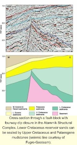
Leads and prospects of several different play types have been identified in the basins and many more are expected as data density increases. Large fault-blocks were formed during the two rifting events, one of which was drilled in the Fylla Structural Complex. Numerous additional fault-block leads exist within this area, in the Atammik Structural Complex and in the areas west of the Hecla and Maniitsoq Rises.
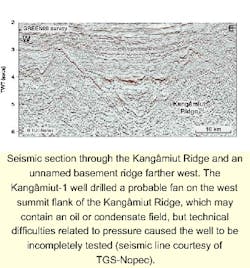
The well Kangâmiut-1 may have drilled into an oil or condensate field, but technical difficulties related to pressure caused the well to be incompletely tested. That reservoir appears to be a fan on the west flank of the Kangâmiut Ridge and numerous other leads may exist as basin floor fans and hanging-wall fans along active faults and fault escarpments in Upper Cretaceous and Palaeogene sediments.
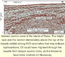
In the 'open-door' area west of Disko, a bright-spot lead that exhibits a strong AVO (amplitude versus offset) anomaly has been identified only 1 km below the seabed. This anomaly could be caused by oil migrating from source rocks below the basalts into a trap above the basalts.
Conclusion
Today's technology is more than adequate for exploration offshore West Greenland, an area with limited water depths and fairly ice-free conditions. The results of the 6354/4-1 (Qulleq-1) well are not known at the time of writing, but will not be critical for exploration over the central and northern part of offshore West Greenland inside the licensing round acreage.
Although the first major oil discovery has yet to be made, the seismic database allows us to postulate that the potential of West Greenland could be similar to the potential of the North Sea. With its proximity to a large market, this should begin to bring activity and investment into these large basins.
No quick success
Greenland's Bureau of Minerals and Petroleum reports that the 6354/4-1 (Quelleq-1) well cut sandstone of Early Cretaceous age, but was not a hydrocarbon discovery. Quelleq-1 (oil lamp) was drilled by the West Navion drillship in 1,152 meters water depth. After logging, it was P & A'd.
Observers point out the difficulty in determining prospective geology in the region and that a similar problem was encountered in early North Sea exploration. While the Groningen Gas Field off The Netherlands was discovered in 1959, it wasn't until 1968 that Phillips discovered oil off Norway (Ekofisk), and 1970 when oil was discovered in the UK sector (BP's Piper).
Seismic scaling up for licensing round
The Government of Greenland and the Danish Minister for Environment and Energy will hold a licensing round in 2001 in areas offshore West Greenland between 63 degrees N and 68 degrees N. The applications closing date will be 01 October 2001. During the winter of 2000-2001, companies can nominate areas to be included.
For areas offshore West Greenland between 60 degrees N and 63 degrees N and between 68 degrees N and 71 degrees N and onshore Disko-Nuussuaq, West Greenland, and in Jameson Land, East Greenland an open-door procedure for applications will be used. Applications in these areas will be considered each year during 1 October to 1 June. Regional seismic data is available.
Most of the data acquired in the 1990s has been funded by authorities or Nunaoil, but in the last several years, the seismic industry has been active off West Greenland with new surveys. Fugro-Geoteam shot a 3,126 km survey in 1998 and TGS-Nopec acquired 2,897 km in 1999. TGS-NOPEC is now acquiring a large non-exclusive survey over the shelf. A total of 2,500 km, out of 8,800 km has been shot, and the survey includes regional transects between Greenland and Canada. A second phase of data acquisition is planned for spring 2001.
Nominations should identify specific blocks. The licensing round is expected to include blocks nominated by companies, and areas covered by seismic surveys carried out in the period 1999-2000. The names of nominating companies will be treated confidentially.
More information on licensing terms, operational conditions, regional geology, and availability of data can be obtained from the following web sites: www.bmp.gl, www.nunaoil.gl, www.geus.dk, www.tgsnopec.no and www.fugro.geoteam.no.


