TGS upgrading seismic data for future exploration offshore Côte d’Ivoire, Equatorial Guinea
TGS is spearheading two new exploration initiatives offshore West Africa.
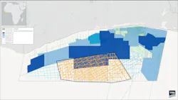
The company has started work on a 19,500-sq km, 2D-cubed project over a deepwater area offshore Côte d’Ivoire, in partnership with PetroCi and the Direction Générale des Hydrocarbures.
TGS is deploying its proprietary 2D-cubed technology, using a structurally conformable interpolation set-up to convert existing 2D seismic data into a regional-scale 3D volume.
The exercise involves integrating more than 14,800 km of 2D data that the company acquired between 2006 and 2014. In 2024, the input data was reprocessed through a pre-stack depth migration sequence.
Final results from the unified 3D volume should provide insights into Cretaceous depositional systems and advance understanding of structural and stratigraphic traps across the deepwater area the company added.
TGS has also signed an agreement with Equatorial Guinea’s government to acquire, process, reprocess and promote seismic and geophysical data across the nation’s offshore basins.
By applying its latest technologies to re-image legacy seismic datasets of varying vintages, the company expects to deliver fresh insights into prospectivity to support current and future exploration, at the same time de-risking petroleum systems in the Rio Del Rey and Rio Muni basins.
David Hajovsky, evp of Multi-Client, said: “Through this agreement, TGS can provide access to a comprehensive data framework, including local, regional, and basin-wide datasets through a MegaSurvey approach.
“This will enable more effective prospect, play, and basin evaluation. In addition, operators in the region will benefit from reprocessed data derived from original field tapes using TGS’ advanced imaging technologies, designed to overcome existing subsurface imaging challenges.”
The agreement extends to acquisition of new broadband seismic data using GeoStreamer multi-sensor technology, the aims being to generate high-fidelity imaging across all target depths and assist more accurate subsurface characterization and reservoir monitoring., TGS said.
About the Author

Jeremy Beckman
Staff Writer / Editor, Europe
Jeremy Beckman has been Editor Europe, Offshore since 1992. Prior to joining Offshore he was a freelance journalist for eight years, working for a variety of electronics, computing and scientific journals in the UK. He regularly writes news columns on trends and events both in the NW Europe offshore region and globally. He also writes features on developments and technology in exploration and production.