Norwegian Sea Geostream X project supports imaging of complex prospective structures
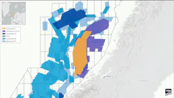
TGS has finished a three-year acquisition and processing campaign for the GeoStreamer X (GSX) project in the Norwegian Sea, delivering the final dual-azimuth products to its clients.
The company says it can now offer more than 21,500 sq km of GSX seismic data for licensing over the offshore region, supporting future near-field exploration and development activities.
The high-density dual-azimuth package, which complements existing GeoStreamer coverage was designed to resolve imaging issues faced by explorers on the Halten Terrace. TGS claims its new dataset enables clearer interpretation of complex structures as well as identification of remaining prospectivity.
While the Halten Terrace features multiple good-quality hydrocarbon reservoirs, these lie within a structurally intricate setting shaped by Late Jurassic rifting.
The resulting horsts, tilted fault blocks and Cretaceous basin floor fans provide diverse play types—enhanced illumination and broadband fidelity provide greater clarity, TGS claims.
Technologies used during the campaign included use of multi-sensor broadband technology, dual azimuth illumination, wide tow sources, dense streamer spacing, and long streamers for velocity model building
Results are said to include improved fault definition, structural imaging and reservoir characterization.
Want more content like this?
Visit the Geosciences section for more daily news, project updates and tech trends.
About the Author
 Jeremy Beckman
Jeremy Beckman
Staff Writer / Editor, Europe
Jeremy Beckman has been Editor Europe, Offshore since 1992. Prior to joining Offshore he was a freelance journalist for eight years, working for a variety of electronics, computing and scientific journals in the UK. He regularly writes news columns on trends and events both in the NW Europe offshore region and globally. He also writes features on developments and technology in exploration and production.