TGS extending 3D seismic database offshore Mauritania
TGS has begun acquiring 3D seismic data for the multi-client offshore Mauritania MegaSurvey.
The program is designed to support future exploration in Mauritanian waters and across the wider West African Atlantic Margin.
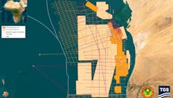
It involves acquiring more than 100,000 sq km of data that will both extend and undergo integration with the company’s existing offshore Mauritania MC library.
TGS plans to deliver one seamless volume across the country’s entire offshore area, which should enable regional interpretation of the full source to sink from nearshore to the ultra-deep.
The company added that the results will provide operators with regional-scale seismic continuity over multiple offshore exploration plays, supporting basin screening, prospect maturation and decision-making.
With a harmonized 3D seismic dataset over such a large contiguous area, clients should be able to approach geological interpretation with greater confidence, with an improved understanding of structural and stratigraphic frameworks to reduce exploration uncertainty.
By de-risking the offshore acreage assessments, clients should also be able to assess exploration capex needs better before committing to drilling or licensing decisions.
David Hajovsky, TGS’ evp of Multi-Client, said, “This regional perspective enables operators to assess Mauritania in the context of neighboring proven and emerging basins, supporting play fairway analysis and a more robust understanding of cross-border geological trends.”