Fugro, TGS start additional seeps survey in the Gulf of Mexico
Offshore staff
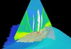
HOUSTON – In collaboration with TGS, Fugro continues to map the seafloor in the Gulf of Mexico to pull together a complete picture of geological features, including hydrocarbon seeps.
This latest survey, Otos, follows the successful completion of another TGS industry-fundedGigante survey in 2016, on the Mexican side of the 1,500-km (932-mi) wide GoM.
Fugro has deployed two geophysical survey vessels to acquire multibeam echo sounder (MBES) and sub-bottom profile data over the western, central, and eastern regions of the US continental slope.
In water depths ranging from 750 m (2,460 ft) to more than 4,000 m (13,123 ft), geoscientists on board theFugro Gauss and Fugro Brasilis will analyze seafloor bathymetry, its acoustic reflectivity, and shallow subsurface structures to identify hydrocarbon seep features on the seafloor and throughout the water column. Both vessels are equipped with hull-mounted MBES systems and the data collected will aid a subsequent geochemical coring campaign.
The final results of the Otos survey will provide novel insight into the regional-scale distribution of hydrocarbon seeps throughout the entire deepwater area of the northernGulf of Mexico. TGS will license the data to exploration and production companies to support development activities in this prolific region.
Fugro Exploration Geoscientist Garrett Mitchell a member of Fugro’s dedicated Global Centre of Excellence for Seep Hunting in Houston, said: “With the acquisition of the Otos seep survey, Fugro will have mapped almost 1,000,000 sq km (386,102 sq mi) of seep and geological features over the entire Gulf of Mexico.”
03/17/2017
