TGS reports several new surveys


TGS has recorded several new offshore seismic surveys scheduled for completion before the end of this year, and all are in northern latitudes.
Rona Ridge 2013 (RR13) is a 2,420-sq km (934-sq mi) 3D survey that will generate the first-ever 3D data in the prospective UK West Shetland basin. Data processing will be performed by TGS with initial data available to clients in 4Q 2013 ahead of the UK 28th Licensing Round.
The Labrador Sea Deep basin 2D survey covering 3,000 km (1,864 mi) and the Labrador Sea 2D Infill survey covering 7,100 km (4,412 mi) will complement and infill the existing 22,167 km (13,774 mi) of 2D data acquired in 2011 and 2012. These surveys should further define and delineate the Henley, Chidley, and Holton basins.
Both surveys will be acquired in partnership with PGS and use the PGS GeoStreamer technology. Initial data is scheduled to be available to clients in 2Q 2014. All three surveys are supported by industry funding.
TGS also has started to expand a 2D multi-client survey off northeast Greenland. The NEG13 survey is in anticipation of the announced Greenland Licensing Round in 2013/2014.
Due to favorable ice conditions, TGS expects to acquire 4,200 km (2,610 mi) of 2D multi-client seismic data. This new data will provide companies with dense data coverage over the licensing area and will be a significant addition to TGS' existing data library in the area.
The seismic data is being acquired by the M/VAkademik Shatskiy supported by the ice breaker M/V Balder Viking. A helicopter is being utilized for ice density monitoring. Data processing will be performed by TGS and should be available to clients in 1Q 2014.
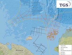
The survey also is supported by industry funding. The accompanying map from TGS shows the planned survey lines offshore Alaska in the Chukchi Sea.
Environmental agreement reached for GoM
There is settlement of a suit involving the use of airguns for seismic surveys in the Gulf of Mexico. The suit was filed by a group of organizations including the Natural Resources Defense Council, Sierra Club, Gulf Restoration Network, and others. The settlement would require a number of steps by industry that the International Association of Geophysical Contractors (IAGC) notes include mitigation measures voluntarily used around the world and others that have been used in the GoM for several years.
The purpose of the suit was to protect whales and dolphins from airgun seismic surveys. The IAGC notes that NOAA Fisheries, charged by the US Congress to enforce the Marine Mammal Protection Act, has found no evidence of serious injury to marine mammals by airgun pulses.