Time-lapse seismic swaths prove cost-effective alternative to full-field 4D
With careful planning, time-lapse seismic technology (4D) swaths can be a cost-effective alternative to full-field 4D seismic acquisition for structurally simple fields and are important in Shell’s North Sea 4D strategy.
The portfolio approach to 4D swath acquisition successfully acquired time-lapse seismic data over four North Sea fields at low cost with minimal preparation. In the case of Nelson and Guillemot fields, processed results support current business activities. For Scoter and Cook fields, the results are less convincing. In all cases, valuable information was acquired.
Keys to technical success are out-of-plane geological dips, which result in imaging errors and serious 4D non-repeatability. This may require up-front modeling to fix the number and location of repeat sail-lines to minimize such errors.
The 2D processing techniques are less able to compensate for seismic acquisition non-repeatability. Consequently, source and receiver positioning repeatability and baseline data quality; navigation accuracy require careful consideration during planning. Using a 4D swath, expect a reduction of at least 5% repeatability relative to full-field 4D. Although acquisition programs are reduced dramatically, the efforts required to process 4D swaths still can be significant.
Normalized RMS is a standard measure for 4D seismic repeatability (noise). NRMS = 2 x RMS (Base-Monitor) / RMS Base + RMS Monitor where RMS is root mean square amplitude measured in a window (usually just above reservoir so as not to include genuine 4D difference)
Swaths can deliver crucial information for field management decisions. However, the limitations of the technique need to be considered, remembering that a negative feasibility result could prevent a full-field 4D and a misinterpreted result could lead to a bad well.
Swaths work when the 4D response is calibrated, i.e., time-lapse signal has been interpreted previously on a full-field survey. They also can detect medium to strong amplitude changes (ΔAI>3%) and large time shifts (>2 ms).
Swaths likely fail if the crossline geological dip is significant (>100) and it might be difficult to extract business value if the 4D response is complicated and uncalibrated, for example, combined pressure and sweep signals, three-phase tuned 4D responses, or spatially complex drainage patterns. In these cases a full-field survey mapping the lateral extents of responses and tying with additional production data may be necessary to understand the 4D signals.
Time-lapse (4D) seismic technology has increased the understanding of producing reservoirs over the past 10 years. The key is a balance between seismic repeatability, magnitude of production-related signal, and timing with respect to the business activities such as drilling in-fill wells or water shut-offs.
A time-lapse swath is defined as a single or a small number of consecutive sail lines of repeated multi-streamer seismic covering a limited area. Baseline data can be dedicated swath acquisition or, more typically, sail lines selected from a previous 3D survey. Relative to a full-field 4D survey, time-lapse swaths can significantly decrease seismic acquisition duration, allow flexibility in terms of vessels and weather windows to reduce costs.
There are two main applications of the technology:
- To robustly and cost effectively test the presence of a production-related seismic signal, prior to the outlay on full-field 4D, where a feasibility study has shown a low technical chance of success
- To allow target-oriented interpretation of production-related 4D seismic signal to support a specific business activity typically around an existing well or proposed well (sometimes providing an update snapshot to a previously acquired and aging full-field 4D).
This can be achieved only with careful acquisition parameters design to ensure repeatability is not compromised. Following are the results of a 4D swath campaign over several North Sea fields in 2005.
Previous swath work
Although successful time-lapse swaths had been acquired previously by Shell, the first North Sea example to demonstrate real business impact was acquired over the Gannet E and F fields in 2004. The Gannet cluster is made up of seven oil and gas accumulations within a turbidite fan complex where 4D is a proven technology. Two additional sail-lines were added to the 2004 4D seismic program to test for a 4D signal at Gannet E and F. Gannet F results showed a clear 4D signal on the difference section, suggesting the eastern part of this single-well field was not being swept efficiently. An infill well was planned, although the final well trajectory was optimized on full-field 3D time-lapse several months later. The infill opportunity identified from the swath data was drilled in 2006 and has been producing beyond expectations, quadrupling field production.
On the strength of the 4D swath success at Gannet E and F in 2004, several North Sea fields were screened as potential 4D seismic candidates for 2005 acquisition, giving a short-list of nine fields. These were screened according to proximity of seismic vessels under contract and the likelihood of co-venture support, and were grouped according to repeat acquisition configurations. Nelson, Scoter, Cook, and Guillemot A were selected.
This portfolio approach was critical in allowing mobilization costs and weather down-time to be shared, particularly as data were acquired in May, near the start of the North Sea weather window. It also accelerated technical and economic approval both internally and externally with nine co-venture companies.
Cooperation with the seismic acquisition teams was essential to determine which seismic vintage to match to actual swath coordinates and repeatability tolerances with respect to geological dip. Cross-line dips were known to be an issue and were minimized by choice of swath location.
Acquisition repeatability
Good 4D seismic repeatability requires good acquisition positioning repeatability (Smit et al., 2005). This means reproducing baseline source and receiver positions as closely as possible during the monitor survey. The 2005 swath program needed to reproduce a number of acquisition configurations using a two-source, eight-streamer set up as used on the previous full-field 4D survey.
This avoided reconfiguration downtime between surveys. Understanding and estimating seismic repeatability is an important part of the feasibility and planning process, as shown in the accompanying figure. Color-coding highlights non-repeatability issues: green represents no problem, orange represents a potential problem, and red is real concern.
Early 1990s Cook and Scoter N-S surveys have limited navigation positioning accuracy due to the absence of active tail buoy and source positioning. This can reduce significantly final 4D seismic repeatability.
For each swath, baseline shot positions were repeated as closely as possible. Having extra cables on the monitor survey relative to the baseline meant the baseline acquisition footprint could be covered by the monitor, even if the cable feathering between them differed. This allowed good receiver positioning without tidal shooting, to save acquisition standby time waiting for the correct point on the tidal cycle. Average source plus receiver positioning difference is a standard measure of 4D acquisition repeatability and the values from the swath shoots - in the order of 60 m (197 ft) - compared well to our best full-field conventional steamer results of 30 m (98 ft), and were well within our quality threshold of 100 m (328 ft).
Processing issues
The most significant processing challenge and the big trade-off with the swath concept is the limited cross-line aperture available for migration. Without adequate aperture for a 3D migration, steep cross-line dips will not image, dipping events will be mis-positioned, and there will be interference from out of plane reflections.
To a large extent imaging errors will be repeated on base and monitor surveys and a reasonable, if not correctly positioned, 4D image results. This assumption may break down for surveys with limited navigational accuracy and/or positioning repeatability, in which case 4D noise will increase with geological dip.
The final repeatability results measured as average NRMS noise can be seen. Guillemot and Scoter NW-SE achieved excellent repeatability and were marginally less repeatable than equivalent 3D time-lapse results. The Nelson repeatability was good, but the NRMS value appears relatively high due to the limited random noise attenuation from 2D processing. The Scoter N-S and Cook swath repeatability were not as good due the age of the baseline surveys. The 4D results confidence was reduced accordingly.
Results
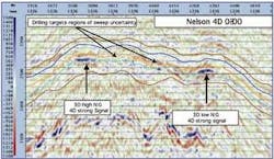
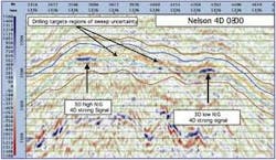
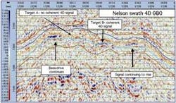
Nelson - The Nelson field is a sand-rich submarine turbidite deposited in the Late Paleocene (Forties) characterized by NW-SE trending main sand channels, channel margins, and minor scale faulting. It is proven 4D territory with repeat seismic acquisitions in 1997, 2000, and 2003 showing clear basal aquifer drive in the lower Forties main channel sands (MacLellan et al, 2006). A two- to three-well campaign was planned for 2006 where existing wells, which largely have watered out due to the rising aquifer, will be sidetracked to areas of by-passed oil. The main aim of the Nelson swaths was to reduce the risk of potential targets being swept by updating the 4D signal. Two swath lines were acquired and matched to seismic acquired in 2000.
We see clear sweep of both upper and lower Forties sands (strong blue loop) from the 3D time-lapse difference signal (2003-2000). The intervening 4D signal in the channel margins is more uncertain, which is precisely the target of the 2005 4D swath. Here the difference signal (2005-2000) shows a continuation of the base-drive of the main channels and confirmation that the upper sand is now showing evidence of sweep in target B but not in A, which remains a potential infill target for the side-track campaign.
Scoter - Scoter is a Late Paleocene gas field in a salt-induced four-way dip closure with low-medium (50-60%) net-to-gross. A substantial graben fault separates blocks B and C, each being drained by a producing well with a third well planned in block A in 2006. The value of this well is dependent on the amount of fault baffling, hence the business driver for the 4D swaths was firstly to identify the extent of fault baffling via seismic changes in the gas-water contact (GWC) and secondly, to determine if full-field 4D would work given the low quality 1991 baseline seismic survey.
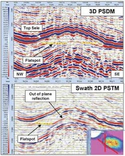
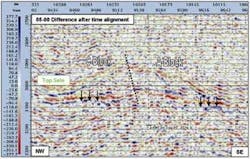
The first observation is that the swath does not image the structural dips of the reservoir compared with the 3D data. However, the GWC, although reduced in the SE, can be observed. Careful parallel processing suggests a visible reservoir related signal at the GWC, which is enhanced after time aligning with the baseline ETAP survey. In this case, the polarity of the 4D signal suggests that the GWC moves deeper, i.e., opposite that expected for typical aquifer sweep. Although different production mechanisms could explain this, the 4D time shifts are small (1-2 ms) and just above the non-repeatable noise. This suggests a 4D signal could be picked up with a full-field 4D repeat. However, evidence of decreased fault baffling was insufficient to impact the planned third well.
Cook - The Cook swath was an opportunity to verify an observable time-lapse signal prior to a full-field survey, while investigating non-repeatability caused by navigation inaccuracy on the baseline seismic. There was also the potential, if a 4D signal was identified, to gain limited (2D) information on water flood patterns and to reduce uncertainty with respect to drive mechanism.
The 4D differences were dominated by steep dips at the high amplitude top reservoir reflector. After time alignment of base and monitor data, a weak 4D signal was visible around the oil-water contact (OWC), but this looked to be an artifact of the alignment, resulting from the limited cross-line migration aperture and non-repeatability at the edges of the swath. The conclusion is that this swath is compromised by cross-line dips in excess of 40°, combined with a weak 4D signal.
Guillemot - The business case for Guillemot was to understand sweep patterns to aid a re-perforation strategy in the Forties reservoir and to chase Fulmar oil targets to the East of the current producers. Due to the steep dips (> 250), the survey was extended 3 km (2 mi) east, so it can be considered as a mini 4D rather than a 4D swath. This succinctly demonstrates that lowering the acquisition costs can enable economic screening of borderline 4D projects. A 4D signal was observed in the Forties and Fulmar reservoirs enabling water front mapping.
Acknowledgements
Thanks to Esso Exploration and Production UK Ltd., Hess Ltd., Oranje-Nassau, Noble Energy, Total E&P UK Plc., Petro Summit Investment UK Ltd., Svenska Petroleum Exploration U.K. Ltd., Petro-Canada and E.ON Ruhrgas UK Exploration and Production Ltd. for permission to print this article. Also, thanks to our other Shell colleagues who were key to the program’s success: Peter Rowbotham, Angus MacLellan, Richard Rogers, Carlo Nicolai, James Hayduk, and Ed Telatovich.
References
MacLellan, A., Rowbotham, P., Rogers, R., Busink, P. and Millington, J. 2006, Integrated 3D/4D structural and stratigraphic interpretation on Nelson accounts for variable fluid contact levels: EAGE 68th Annual Meeting.
Smit, F., Brain, J. and Watt, K. 2005, Repeatability monitoring during marine 4D streamer acquisition: EAGE 67th Annual Meeting.
