Victor Schmidt
Houston
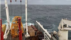
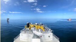
The M/V Polar Queen and M/V Geco Angler (shown) re-shot the original 1995 source pattern over Foinaven Field to produce its first 4D survey.
Tanzanite, Hickory keep subsalt interest high
Anadarko Petroleum grabbed the spotlight with two recent subsalt discoveries: Tanzanite and Hickory in the Gulf of Mexico. Widely separated areally, both subsalt discoveries are on the shelf in just over 300 ft water depths. Tanzanite is in Eugene Island Block 246 (314 ft WD) while Hickory is in Grand Isle 119 (320 ft WD).Operators are gradually learning the secrets of subsalt exploration. By testing the shelf first, they can develop facilities using standard technology and keep costs reasonable. To date, 36 Gulf of Mexico subsalt wells have been drilled. The first subsalt well was drilled by Placid Oil in Ship Shoal Block 366 in 1983. For
a complete listing of subsalt drilling in the
Gulf, explorewww.gomr.mms.gov, the Minerals Management Service's website.
Moroccan survey
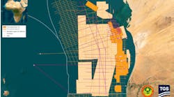
Schlumberger Geco-Prakla is conducting a 2D survey for Vanco Energy of Houston over its recently awarded Safi Haute Mer reconnaissance license offshore Morocco. The M/V Akademik Nemchinov is collecting the 1,850 km of data from the shore out to 3,000 meters of water. The survey is being collected as part of a one-year geological and geophysical study. The permit has three main geologic plays:- Near-shore Hercynian structures of Paleozoic age
- Jurassic reef/carbonate banks
- Deepwater Cretaceous/Tertiary sands.
Ultradeep survey off Nigeria
Veritas DGC in partnership with Digital Exploration will conduct a regional speculative survey in 2,000-5,000 meters water depth in an area south and west of OPL 243 to OPL 247 off Nigeria. The survey will tie into the 1990-1991 regional grid of data collected by Mabon-TGSI. The vessel S/V Professor Kurensov will acquire around 10,000 km of 2D data in the initial schedule. Additional 2D or 3D speculative surveys are possible.Foinaven reservoir monitoring evaluation
The Foinaven Active Reservoir Monitoring (FARM) project completed its first 4D seabed and towed streamer acquisitions in the North Atlantic. Schlumberger recently completed a 3D towed streamer survey that will be compared with an earlier 3D survey, shot as part of the discovery of Foinaven Field.The 36 km trenched hydrophone array has been on the seabed for three years at a depth of 500 meters.
Two Schlumberger Geco-Prakla vessels were used to collect the new 3D survey. The M/V Polar Queen connected its recording system to the seabed array while the M/V Geco Angler re-shot the original 1995 source pattern. Trenching of the seabed array assured positional and coupling repeatability for the receivers.
The two sets of 3D surveys will allow BP, Shell, and Geco to directly compare the 4D towed array analysis and 4D trenched survey analysis. Key goals are to gain information on:
- Changes in oil and gas reservoir saturation
- Pressure effects
- Spatial calibration of the reservoir simulation.
Reservoir analysis software upgraded
GeoQuest released an upgrade to its Oilfield Manager (OFM) well and reservoir analysis software. The software is open to third-party products, and has a new 32-bit architecture and a redesigned user interface for reduced cycle time. New functionality includes Fetkovich-type curve analysis, a material balance module and a back allocation module for accurate production volume allocation. "OMF's modules contribute to a better understanding of the reservoir's production data," according to Victor Ward, GeoQuest Manger of Production and Drilling Product Planning. For additional information, access the GeoQuest web page at www.connect.slb.com.GeoFrame extends into reservoir cycle
At GeoQuest's Forum '98 an overview of GeoFrame 3.5 was presented that examined some of the 800 enhancements to the interpretation software. The product suite offered by GeoQuest continues to expand and integrate more of the detailed functionality needed by the industry. Integration through the reservoir life cycle is the goal of the company's software development. Users are driving the industry to produce a common earth model on which each professional group can apply its software and expertise.GeoQuest noted that its survey of the industry shows most companies retaining UNIX and PC platforms with a gradual move by smaller operators to Windows NT. Longer term, it sees web-based Java systems entering the mix. Open software architectures and the ability to operate independent of hardware is becoming more important.
GeoQuest will create drill ing and production modules over the next year by integrating software to serve well planning and production tracking/simulation needs. A new concept, Cyber geo logist, will apply geologic models with "rules" to seismic volumes. These templates will help interpreters quickly develop and update interpretations in complex seismic volumes.
Virtually global
Statoil, Landmark, and Silicon Graphics successfully delivered a remote site-to-site virtual reality environment from the Landmark Houston facility to Statoil's Stavanger, Norway location. This officially opened Statoil's Advanced Visualization Center in November. The center will be used to make interpretation and wellbore planning decisions in a collaborative cross-functional environment.Harald Norvik, Statoil CEO, stated, "The opening of Statoil's Advanced Visualization Center in Stavanger, Norway is witness to a technological breakthrough. As a learning organization in a global environment, our ability to collaborate across organizational, geographical and professional boundaries is crucial to our success as corporations. Today, we are experiencing an example where all these boundaries are being crossed. We will see people belonging to different companies, in different continents and from different disciplines working together."
Silicon Graphics' hardware and software provided the infrastructure for high performance visualization that included real-time interaction with a Onyx2trademark workstation, and a large Trimension Systems multi-channel display screen with remote screen synchronization in an immersive virtual reality environment.
"Lankmark's facilities, called Decisionariumstrademark, are designed to effectively operate in a cross-functional environment to help make exploration, drilling, and production decisions - faster and more accurately," according to Robert P. Peebler, Landmark's President and CEO.
Copyright 1998 Oil & Gas Journal. All Rights Reserved.


