BGP works complex offshore/onshore seismic survey
Gene Kliewer • Houston
BGP is conducting a very complex 2D TZ seismic survey in the Red Sea. The complicated terrains include city limits, muddy beach, shallow water island, coral reef, offshore ports, and areas near offshore oilfield infrastructure. These complex surface conditions present several challenging difficulties for seismic operation such as drilling, air-guns, receiver cable deployment, positioning, and quality control.
BGP has formed a series of solutions to address the issues. Three different types of sources have been used: vibroseis, explosives, and air guns. For recording, both a cable system and a node system were used simultaneously. Three types of sensors, geophones, marsh phones and dual sensors were used in the cable system, while the node system was deployed at the sea floor in deepwater areas (more than 50 m or 165 ft deep).
Bergen Oilfield Services AS has sent its 2D/3D vessel BOS Atlantic to West Africa for the NWAAM 2D regional multi-client program. This follows earlier announcements that BOS committed to target an early data delivery. The BOS Atlantic recently upgraded to include the latest ION Digistreamer as well as the ORCA 2D INS from ION Concept Systems. The vessel also remains exclusively rigged for arctic surveying technology. In West Africa it is expected that the vessel will work both on the NWAAM survey as well as responding to proprietary survey requirements in the area.
Apache Northwest Pty. Ltd. says the Gazelle 3D seismic survey covering WA-399-P offshore Western Australia is underway and the acquisition phase should be compete by press time.
WA-399-P is in the Exmouth sub-basin and adjacent to the Pyrenees development.
Partners in the permit are Apache Northwest (60% and operator), Jacka Resources Ltd. (15%), Carnarvon Petroleum Ltd. (13%), and Rialto Energy Ltd. (12%).
The block is adjacent to the Pyrenees Oil development, a joint venture between BHP Billiton and Apache PVG Pty Ltd, which commenced oil production in February 2010. Nearby, there are several producing oil fields including Enfield and Vincent/Van Gogh, as well as the Macedon gas field, currently under development, and a number of other oil and gas fielPolarcus Ltd.has contracted withProvidence Resources PLC for a 3D seismic acquisition project in the Celtic Sea offshore Ireland. The survey will commence in June 2011 and is expected to run for approximately 15 days.
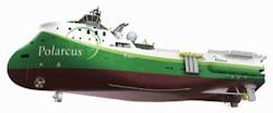
Polarcus Samur Ltd. took delivery of thePolarcus Samur the fourth 3D seismic vessel to join the Polarcus fleet. The vessel was built at Drydocks World – Dubai in the UAE and is under way to Namibia to commence a charter for HRT Participações em Petróleo S.A. and UNX Energy Corp. Samur is an arctic-ready 3D seismic vessel of the ULSTEIN SX133 design capable of towing both conventional and wide tow spreads, including the company’s First Pass 3D technique. The SX133 has an overall length of 84.2 m (276 ft.) and a beam of 17 m (55.75 ft).The vessel has a maximum speed of 17 knots and is capable of deploying up to eight streamers each 6,000 m (19,685 ft) long, or six streamers each of 8,000 m (26,245 ft) length, with lateral streamer separations of between 25 and 200 m (82 to 656 ft). This artist’s rendering of the vessel is courtesy Polarcus.
New technology comes to market
The just releasedPetrosys 16.9 version now has direct links to Paradigm’s EPOS 2D and 3D navigation and interpretation data. The release also adds direct access to seismic interpretation from SeisWare for gridding and upgrades connectivity to Petrel 2012.2 for reading seismic interpretation.
Fugro-Jason has released EarthModel FT 4.2 geological modeling software. The software builds on the UpdateAbility and TrackAbility features to update subsurface models quickly, says Fugro-Jason.
New features and enhancements in EarthModel FT 4.2 include:
- Petrel Plug-in, allowing import/export of grids and properties
- OpenSpirit Link, allowing import from all OpenSpirit-enabled applications
- Upscaling enhancements to the RockScale module, including facies and lithology property import, and also permeability, water saturation, net-to-gross, porosity, and probability upscaling
- Fault export to Eclipse and Rescue
- Improved link to PowerLog well log data base.
Offshore Articles Archives
View Oil and Gas Articles on PennEnergy.com


