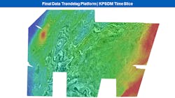
PGS issues offshore Trøndelag Platform survey findings
Offshore staff
LYSAKER, Norway – PGS has released final time and depth imaging products on its PGS19M02 seismic survey offshore Norway.
The Trøndelag Platform project deliverables include full depth processing, and the application of velocity model building to the entire volume with full waveform inversion (FWI) and reflection tomography.
The PGS19M02 survey was acquired in September 2019 over 10,500 sq km (4,054 sq mi) on the Trøndelag Platform, including the Helgeland and Froan basins.
According to the company, it covered parts of acreage awarded to some of the most active players on the Norwegian continental shelf in previous APA rounds.
Use of GeoStreamer technology has provided improved seismic velocity estimation and better imaging of the Jurassic targets and the presalt potential in the Permian, PGS said, to support prospect evaluation and exploration for new plays.
In addition, the AVO-compliant dataset can serve as a baseline survey for future 4D studies.
In an unrelated development, PGS and Ocean Floor Geophysics (OFG) have signed an agreement that gives OFG exclusive rights to use the hardware, software, and intellectual property associated with PGS’ towed streamer CSEM (controlled source electromagnetic) system.
The towed-streamer technique is said to allow for fast and efficient acquisition of marine CSEM data.
Dr. Lucy MacGregor, principal scientist at OFG Multiphysics, said that the technology “is a perfect complement to existing seismic data when added confidence is needed to qualify acquisition, drilling or relinquishment decisions.”
Under the agreement, PGS will be offered shares in OFG, which also offers processing, interpretation and multiphysics seismic integration.
09/08/2020
