Geosciences

Gene Kliewer • Houston
Greenland gravity survey set
The Cairn Energy group and joint venture partner Nunaoil have contracted ARKeX to conduct the first-ever marine gravity gradiometry survey offshore western Greenland. Targeted is 5,000 sq km (1,931 sq mi) on blocks 1 and 3, called Sigguk and Eqqua, awarded to Cairn in the Disko West licensing. The survey is to include gravity gradiometry, magnetic, and bathymetry measurements.
Big Wave Phase 2 scheduled
Spectrum is scheduled to be running 12,000 km (7,456 mi) of long-offset seismic data acquisition as part of its Big Wave program in the eastern Gulf of Mexico. The project is scheduled to be completed in November. Phase 1 of the survey along and out from the Florida Escarpment was processed by Spectrum in Houston with both Kirchhoff and Wave Equation pre-stack depth migration and shows a number of possible accumulations, according to Spectrum. Phase 1 covered 38,000 km (23,612 mi) of surveys, some acquired and processed in partnership with TGS-NOPEC.

Artemis 3D processed
Petroleum Geo-Services Australia Pty Ltd. has completed the Artemis 3D seismic survey and data processing covering 97 sq mi (250 sq km) offshore Western Australia in WA-360-P in Carnarvon basin. TheOrientExplorer ran the data acquisition survey for MEO Australia Ltd. with the intent of defining drilling locations for 2010. MEO subsidiary North West Shelf Exploration Pty Ltd. operates WA-360-P with 70%. Partners are Cue Energy Resources Ltd. and Gascorp Australia Pty Ltd., each with 15%
Seychelles oil slick mapped
The largest oil slick mapping project ever offshore Seychelles is complete. Infoterra Ltd. and Seychelles Petroleum Co. reviewed and mapped more than 150 radar satellite images covering 500,000 sq km (193,051 sq mi).
"Seeps data is valuable information prior to any exploration, especially in this relatively unexplored region," says Patrick Joseph, exploration manager for Seychelles Petroleum Co. "We will use this data to support the planning of seismic projects and subsequent geochemical progams."
Spanish Point 3D under way
Providence Resources Plc. has contracted Bergen Oilfield Services to use theBOS Angler to acquire approximately 300 sq km (116 sq mi) of 3D seismic data at the Spanish Point (FEL 2/04) license in the Porcupine basin off Ireland following the Jurassic discovery at 35/8-2. Providence (56%) operates the permit for partners Chrysaor E&P Ireland (30%) and Sosina Exploration (14%).
New technology reaches market
Fugro-Jason has announced pending 3Q 2009 release a new version of its Geoscience Workbench. The release has new AVO Attribute/Analysis and Full Waveform Synthetics with other enhancements to previous programs, according to Fugro-Jason. The new AVO Attribute/Analysis module will allow extraction of seismic AVA or AVO attributes from pre- or partial-stack seismic data. The company says options include:
- Shuey 2-term (intercept and gradient)
- Shuey 3-term (intercept, gradient, and far-offset)
- Smith and Gidlow (Vp and Vs contrasts)
- Fatti et al. (Zp and Zs contrasts)
- Gray et al. (λ, μ and ρ contrasts).
An add-on to the Well Log Editor provides full waveform synthetics. Pre- and post-stack NMO synthetics with and without multiples can now be calculated. Using well control, this module allows analysis of which seismic events are primaries and which ones are not.
Seismic Micro-Technology has released version 8.4 of its KINGDOM Advanced interpretation software. According to SMT, the new geoscientific interpreter includes Advanced Autopicker and support for Surface Volume Curvature attributes. Advanced Autopicker picks through complex geologies and near-vertical events and requires only a few initial seed picks in order to provide a high-quality interpretation, says SMT.
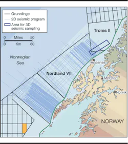
TheOcean Explorer is scheduled to wrap-up a seismic survey north of Senja in the Troms II area of the Norwegian North Sea this month. The survey is part of a NOK 25 million ($3.8 million) project into fish response to seismic surveying. The project is being done by the Institute of Marine Research for the Norwegian Petroleum Directorate and includes the participation of local fishing vessels. The fishing vessels are to fish in the seismic test area before the testing and again after to determine how long it takes for fishing to return to pre-seismic levels. The NPD is surveying Troms II and Nordland VII areas to determine development potential for inclusion in a management plan for the Barents Sea and offshore Lofoten in 2010.
