Geoex MCG updates northwest Europe seismic survey targets
Offshore staff
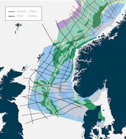
EPSOM, UK – Geoex MCG has completed its Regional Deep Imaging 2021 (RDI21) cross border survey in the North Sea.
The 8,566 km (5,323 mi) of seismic and gravimetry/magnetic data were acquired between May and July. Processed results should be available next spring.
The project comprised 16,300-km (10,128-mi) long seismic 2D profiles that image large-scale, deep-seated crustal structures, providing longer offsets than existing data over areas of offshore borders between Norway, the UK, the Faroe Islands, and Denmark.
Final processed data is now available from the Quad 35 Hybrid MC3D data, a joint venture between Geoex MCG and Seismic Partner.
This is said to be the world’s first combined MC3D Ultra High Density streamer and node survey acquired simultaneously, covering various fields and discoveries plus newly relinquished acreage (including a large undrilled upper Jurassic prospect) available for Norway’s APA 2021 licensing round.
08/13/2021
