Exploration returning offshore Mozambique with prospect of oil in emerging plays
Majors lured by latest geological studies, reformed fiscal law
Anongporn Intawong, P. Hargreaves, N. Hodgson, K. Rodriguez, Spectrum Geo
Mozambique hasbeen at the epicenter of attention offshore East Africa following Anadarko and Eni’s discoveries of over 100 tcf from 2010 onwards in the deepwater Rovuma basin off the country’s northern coast. The Mozambique margin to the south is also viewed as gas-prone due largely to these finds and the smaller deepwater gas discoveries farther north off Tanzania.
However, the arguments for an oil play in the Mozambique Channel and East Zambezi basin are growing stronger, based on natural oil seeps, analysis of source rocks, and seismically interpreted indicators. The hunt for oil is now on in this potentially prolific area, and some super-major oil companies are already leading the way.
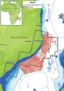
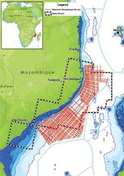
Sea surface oil slick study extent and Spectrum’s recently acquired multi-client 2D seismic data over the Angoche basin, Mozambique Channel. (All images courtesy Spectrum Geo)
Detection methodology
Satellite images can be examined for evidence of oil floating on the surface of the sea, caused by natural oil seeps generating oil slicks that appear in re-occurring, persistent clusters that are visible for several years. These slicks are indicative of an underlying oil-generating petroleum system that is clearly working - the ‘Holy Grail’ for explorers investigating new basins. The technique takes advantage of the difference in the sea surfaces wave pattern, or ‘texture,’ between the sea surface in its natural state and with oil floating on top of it. In suitable conditions the sea surface is slightly rougher in an oil-free state, and an oil slick will reflect sunlight in an anomalous way that can be detected on the satellite image (MacDonald et al., 2015).
Over 240 satellite images acquired over the Mozambique Channel from 2013 to 2017 have been analyzed to quantify the number and distribution of sea surface oil slicks in the Angoche basin, the Mozambique Channel and the East Zambezi basin which lie between the Rovuma basin to the north and the Zambezi Delta to the west.
Distinguishing between human pollution and naturally occurring slicks is also critical. Various methods have been used to determine the origin of slicks, to ascertain whether they are geological seeps or superficial anthropogenic discharges. Many other sources of apparent slicks need to be screened out such as areas of very low wind speed, upwelling, biogenic slicks from algal blooms, fishing activities, and fluvial run-off from land processes. Therefore, the slicks identified within the study area were also checked using the diagnostic infra-red band data captured by the satellite.
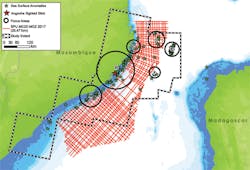
Sea surface oil slicks distribution and occurrence. Some are in clusters re-occurring over time (highlighted in black circles). Onshore oil seeps are also in evidence at Angoche (shown as red star).
By looking for locations with persistently re-occurring slicks found on images taken on different days, and over months and years, random pollution events can be ruled out, with a greater likelihood that the oil slicks are indicative of a naturally occurring thermogenic oil source. These slicks are then correlated with seismic data to investigate the geological relationship of hydrocarbon migrating from the source rock to a seep point where the oil enters the sea and finally to the oil slick location. The results can provide key evidence of a working oil-generative petroleum system.
Sea surface observations
In total 120 sea surface slicks were identified across the study area, with some found in clusters re-occurring over time. The majority of the slicks line up at the shelf break along the coast of Mozambique. On seismic it is evident that sedimentary sequences from the Mozambique Channel dip upwards toward the steep present-day shelf edge. Therefore, it is likely that a mature oil source in the center of the basin is responsible for hydrocarbon migration up-dip and north or west toward the Mozambique shelf.
Some clusters of re-occurring oil slicks have been identified along the abrupt compressed sedimentary package to the east known as the Davie Ridge, which for many represents the strike slip fault that allowed Madagascar to break away from Tanzania in the Early Jurassic, moving southeast to its current location, at the same time as Antarctica broke away from Mozambique moving south. Satellite scenes only cover the northern portion of the Davie Ridge, but here again seismic shows that basinal sedimentary sequences dip-up toward the ridge, suggesting that oil migration and seepage are possibly controlled by the dip of the sediments.
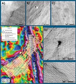
Example of sea surface oil slicks and their locations on Bouguer gravity anomaly map and new multi-client broadband 2D seismic coverage.
Oil evidence/migration pathways
The distribution and occurrence of the slicks provides strong evidence that there is a mature oil source in the Mozambique Channel. It is not possible to identify from the distribution the age of the source rock from whence it comes, but three possible source rock intervals have been proposed. The oldest comprises the Middle and Late Jurassic sequences deposited as Antarctica moved south, forming a small enclosed basin idea for the deposition and preservation of organic rich shale. The overlying source rocks of the Early Cretaceous marine shales are known from along the East African coast and indeed globally as they were deposited in periods of global deep-sea anoxia. Lastly, where fragments of continental crust have been left behind by migrating continents, an older ‘Karoo’ age source rock may be found, especially along and east of the Davie Ridge.
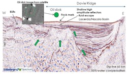
On seismic data these source rocks are observed to have strong soft kicks at the top of the sequence, clear type 4 AVO anomalies and reduction in frequency – all classic characteristics of effective source rocks, applying Loseth et al. (2011)’s methodology. Other evidence for direct hydrocarbon indication (DHIs) observed on seismic includes: bottom simulating reflectors, pock marks, fluid escape features, and high-amplitude (bright) reflectors. Some of the oil slicks appear to have a strong spatial correlation to pock marks, fluid escape features and shallow high-amplitude reflectors, and are supported by geological features such as fault and erosional surface that can facilitate the migration of oil seeping to the sea surface.
Bottom simulating reflectors, pock mark, and shallow high-amplitude reflectors found in seismic profile showing strong relationship to sea surface oil slick.
More support for the oil play comes from onshore oil seeps at Angoche and Mucifi (north of the study area), which may be sourced from the Middle to Early Jurassic marine, or even the Karoo (Mahanjane et al., 2014). Several oil seeps have also been identified along the coastline west of the Ibo High in the southern Ruvuma (Davison and Steel, 2017). The ODP well 629B drilled on the conjugate Antarctica margin penetrated 45 m (147 ft) of Early Cretaceous (Valanginian) source rocks containing Type II marine kerogen, with an average of 10% TOC and HI of 300-600 mg/g TOC (Thompson and Dow, 1990).
Key to establishing more evidence that the source rocks in this area are generating oil has been the acquisition of new 2D seismic data in 2017, which has allowed the industry’s understanding of the area’s hydrocarbon potential to be refined, thereby accelerating hydrocarbon exploration activity. Ongoing seismic interpretation and prospect mapping of the new 2D seismic data have already identified potential targets in both structural and stratigraphic trapping geometries along this Mozambique margin.
In 2017 and 2018, Spectrum acquired a multi-client 2D regional broadband seismic survey designed to image the subsurface potential in the Angoche basin, Mozambique Channel and East Zambezi basin, thereby providing a more detailed understanding of the prospectivity in areas where no wells have been drilled to date. Drilling targets along the margin have already been identified on these new data with Cretaceous and Tertiary reservoir and seal-paired intervals identified in plays that include onlaps and drapes over basement highs, stratigraphic and structural traps of deepwater slope channels and basin floor fans, lowstand plays (both wedge and pro-delta fan), drapes over strike-slip faulted structures, and compressional plays near the Davie Ridge.
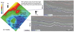
Example of potential basin floor fan play within structural trap in the Early Cretaceous interval, with structural drapes over basement highs, and four-way dip-closed structures (A and B) extending over up to 509 and 207 sq km, respectively.
Enhanced clastic reservoir quality is to be expected from turbidite systems interacting with strong contourite or slope parallel drift bottom currents. In these ‘mixed turbidite - contourite systems,’ turbidite currents are thought to winnow, flowing down dip, taking away the silty fines and leaving sand reservoirs of exceptional quality. Globally knowledge of such depositional systems is growing rapidly but the best examples available are from the nearby Rovuma basin, such as the reservoirs in the Lower Eocene Coral discovery (Palermo et al., 2014). Late Cretaceous near-shore marine sandstones (Grudja formation) are the main reservoirs in the Pande, Buzi, Tamane and Inhassoro fields in southern Mozambique, exhibiting up to 30% porosity and up to 5,000 mD permeability (Matthews et al., 2001).
Other than a source rock, the main ingredient required in petroleum system to generate oil is heat. Too little heat, no oil is generated, while with too much heat, only gas is generated. As the earth gets warmer with depth there is a need to find a source rock in the ‘Goldilocks Zone’ where the temperature is just right for generating oil. Recent understanding of the influence of active rifting and the Comoros mantle plume causing elevated heat flow in the northern Rovuma basin has explained the anomalously high geothermal gradient - around 40°C/km - observed in wells in that area (Duncan MacGregor, personal communication, October 10, 2018). This high rate of increase in temperature with depth in Rovuma has meant that the source rocks in that area are heated beyond the point where oil is generated and are forced to generate only methane gas. While this has produced copious quantities of gas, this will not occur in the Mozambique Channel being farther from the Comoros mantle plume, across the Davie Ridge on young oceanic crust. Indeed, the wells drilled in the Zambezi Delta show half the geothermal gradient, at around 20-25°C/km (Duncan MacGregor, October 10, 2018), of those in Rovuma, resulting in the source rocks of Jurassic to Early Cretaceous age sitting in the peak oil window: the Goldilocks Zone. This analysis is supported by 1D basin modeling of Mahanjane et al. (2014). If these source rocks generate anything – they will generate oil.
Next-phase exploration
Following the success of exploration, appraisal and commercialization of gas in the Rovuma areas 1 and 4, it is significant that exclusive activities are now beginning in the East-Zambezi to Mozambique Channel area. Exploration and development rights of the offshore blocks awarded under Mozambique’s fifth licensing round between the oil companies and the National Petroleum Institute (INP) have led to a reformed fiscal law and contract legislation. This remarkable result will certainly lead to a more positive investment atmosphere and undoubtedly strengthen operators’ confidence in future hydrocarbon exploration in Mozambique.
Exploration is returning to offshore Mozambique – but this time, the hunt is for oil. •
References
• Davison, I., and Steel, I., 2017. Geology and hydrocarbon potential of the East African continental margin: a review. Petroleum Geoscience, 24, 57-91.
• Loseth, H., Wensaas, L., Gading, M., Duffaut, K., and Springer, M., 2011. Can hydrocarbon source rocks be identified on seismic data?. Geology, 39 (12), 1167-1170.
• MacDonald, I. R., Garcia-Pineda, O., Beet, A., Daneshgar Asl, S., Feng, L., Graettinger, D. French-McCay, D. G., Holmes, J., Hu, C., Huffer, F., Leifer, I., Mueller-Karger, F., Solow, A., Silva, M., and Swayze, G., 2015. Natural and unnatural oil slicks in the Gulf of Mexico, Journal of Geophysical. Research, Oceans, 120, 8364–8380.
• Mahanjane, E.S., Franke, D., Lutz, R., Winsemann, J., Ehrhardt, A., Berglar, K. and Reichert, C., 2014. Maturity and petroleum systems modelling in the offshore Zambezi Delta depression and Angoche Basin, Northern Mozambique. Journal of Petroleum Geology, 37: 329–348.
• Palermo, D., Galbiati, M., Famiglietti, M.,·Marchesini, M., Mezzapesa, D., Fonnesu, F., 2014, Insights into a New Super-Giant Gas Field - Sedimentology and Reservoir Modeling of the Coral Reservoir Complex Offshore Northern Mozambique. Offshore Technology Conference, 25-28 March 2014, Kula Lumpur, Malaysia.
• Thompson, K.F.M. and Dow, W.G., 1990. Investigation of Cretaceous and Tertiary kerogens in sediments of the Weddell Sea. In: Barker, P.F., Kennett, J.P., Masterson, A. and Stewart, N.J. (ed.), Proceedings of the Ocean Drilling Program, Vol.113, College Station, Texas, 189-197.
