p.2 ~ Exploring Greece with a new subsurface perspective

A broader view on the geology
The offshore Greece area contains a variety of sedimentary environments. The basins involved are associated with a series of different structural settings, ranging from the fore-arc succession south of Crete, to the outermost part of the fold-and-thrust belt of the External Hellenides in western Greece and the corresponding forelands, being underlain by the westwards overthrusted Apulian platform. As such, the region is structurally challenging – being influenced by the Hellenides, the Central Hellenic shear zone, and its corresponding strike slip faults such as the Kefalonia transform fault (KTF) – creating both compressional and extensional structures, which are often closely related time-wise. The right-lateral KTF separates the area into a North Ionian region covering the Apulian platform and Paxi zone, and a Central Ionian region covering the Ionian and Paxi zones, moving the Ionian zone onshore north of the fault. Carbonate deposition dominates the region up to the Eocene/Oligocene in the Ionian zone, and up to Messinian times on the Apulian platform, causing a large amount of the seismic energy to be lost at the clastic/carbonate interface. Furthermore, Triassic salt in the Ionian zone is mobilized along thrust faults folding the adjacent strata. With the sparse well data available, interpretation relies heavily on the seismic data, making quality imaging crucial.
North Ionian region
The Apulian platform is dominated by carbonate deposition up until the Messinian, a period when the Mediterranean was exposed to extreme changes in sea-level. The resulting top carbonate reflector is extremely strong, both on the platform and in basinal areas. Results show two seismic lines from the eastern edge of the Apulian platform, illustrating a common structural feature along the platform slope, demonstrating the benefit of broadband seismic versus reprocessed legacy data. The new seismic data provides crisper imaging of fault planes in this zone. The faulting is most likely caused by the flexure of the platform due to the influence of an east and a west-verging fold-and-thrust belt, the Apennines and the Hellenides, respectively. The younger clastic interval is sourced from the erosion of sediments as a result of the growing Ionian thrust in the east, creating a young foreland along its western edge.
One aim when acquiring the new dataset was to image deeper targets than previously possible, such as the Permian-Triassic shelf clastics, remnants of the African plate. This succeeded, showing a prominent deeper black reflector (peak – decrease in AI) marking the base of the carbonate succession and onset of what is inferred to be the older clastic sequence.
Moving off the platform eastwards, further into the Paxi zone and then into the Ionian zone, the structures related to the prograding Hellenides fold-and-thrust belt become more prominent. Results show a clearly imaged fault-related anticline located along the same northwest/southeast trend as Paxos Island, where along its northeastern edge, several related thrusts and synclines are shown. Improving the imaging of the anticlines facilitates the interpretation and identification of potential sub-thrust targets. These have proven to be an important trap type in Albanian fields.
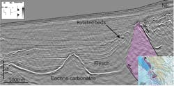
Central Ionian region
Offshore Peloponnese, south of the KTF, the structural picture becomes more complex with the onset of the salt-influenced, thrust-affected Ionian zone. The new seismic data allows for delineation of the complex fault patterns. The Triassic evaporites are mobilized and flow along the major thrust and faults associated with the progradation of the fold-and-thrust belt. Shallow salt structures often associated with back-thrusts are created as a result. Located eastwards, the Ionian zone was affected at an earlier stage than the Apulian platform, by the Hellenides thrusting. The Ionian zone was part of the Pindos Foreland, where the clastic input from the prograding thrust front in the east led to a cessation in the carbonate production. This Oligocene flysch is seen to be, locally, both conformable with and onlapping the Eocene and older carbonates. The onset of movement of the Triassic salt along the thrust faults affected this flysch, creating upturned layers and possible traps adjacent to the thrusts.
Southern Ionian region
The southern Ionian region covers the fore-arc region of Crete, with a geological setting differing from the Northern and Central Ionian regions. The area is largely influenced by overall subduction of the African plate, with several strike slip faults creating pull-apart basins and push-up structures. This area remains a frontier, largely due to the water depths.