Opportunity for better satellite communications
Disasters, natural or otherwise, are terribleto endure. Those operating companies and vendors involved in Gulf of Mexico operations know this all too well. And one thing is certain: The basic, yet critical “ship to shore” communication infrastructure in large areas of the Gulf has been rendered impotent following three major hurricanes in less than 90 days.
However, some Gulf operators, in concert with contractors, were able to connect effectively, efficiently, and reliably with remote transportation assets using innovative communications equipment and solutions. This circumstance and how some companies handled communication challenges provided a laboratory experience to guide everyone in dealing with the next big storm.
It’s an outline for real change.
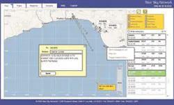
The first tracked aircraft into the Gulf as the eye of Hurricane Katrina was passing over the Mississippi coast was a Sikorski S61 owned by Cougar Helicopter and contracted by a major oil company. It was equipped with both Blue Sky Network SATCOM voice and tracking solutions. From the moment it left shore until its return, anyone, anywhere (with permission) could, and did, follow and communicate with it. In fact, other helicopter operators flew alongside the Cougar chopper and used its crew and SATCOM voice capability to communicate back relevant location and damage information to their customers and other interested parties. The Cougar chopper became an airborne mobile “repeater” while still sending its own tracking data and visibility back to shore.
By cutting critical time to act, this information gave recovery logistics managers a real head start on alternative solutions. Moreover, the S61 (and others with Blue Sky Network equipment) continued to be tracked by people on shore using SkyRouter, a just released, innovative web-based mapping, asset tracking and two-way communication solution, to stack the odds in favor of aviation safety for the crews of these operators. Because SkyRouter is a web-based solution, it can be accessed and used for such linkage anywhere in the world where an Internet connection is available.
Tracking and maps
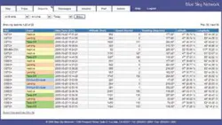
Blue Sky Network built SkyRouter from the ground up, with oil and gas customers providing input to meet the industry’s unique requirements. It was designed so that people in, say, Houston could see and link with operations in Africa, or that a contractor could offer customers real-time visibility of current activity and history, as well - anywhere in the world. SkyRouter receives satellite messages from aircraft in flight, vessels in the water, or end-users on the ground, in the form of GPS position reports, two-way text messages, or telemetric data reports, each in a clever, easily understood manner.
The SkyRouter’s global map depiction is what a tracking map should be: informative, relevant, and user friendly. The SkyRouter map is easy to understand. In North America, the map is scalable down to street level. If a customer has a special local map, for example, of Angola, then SkyRouter can add this layer to that user’s view. Block lease boundaries in the Gulf of Mexico are already there. Each user can add defined locations (rigs, fuel depots, pipelines, etc.) at any time.
Delivery configurations
All Blue Sky Network equipment starts with a single-channel aviation antenna that carries both a GPS signal and Iridium satellite signal down one coaxial cable to the modem transceiver box. Blue Sky Network products provide a range of configurations for custom assembly according to user specifications. These include tracking only; tracking and laptop connection; tracking, voice and two-way messaging; voice only, etc.
The combination of intelligence in the modem transceiver box, in concert with the interpretation of the server on the ground, allows for intuitive event management. For example, it will broadcast a takeoff message when the aircraft exceeds a user-defined speed or extends beyond a “paused” location. There also is the quick position alerting system that, once activated, shows on the vibrant mapping display, in urgent red, who reported this status and where it is.
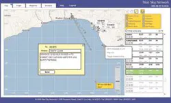
Companies can get a flight plan from the unit to the dispatcher right through the network easily and efficiently. In addition, SkyRouter allows the authorized user to manage these assets remotely, changing parameters on the fly, so to speak, if desired, without pilot intervention.
This technology is relevant not only for helicopters and aircraft, but for all mobile assets. The day after Katrina struck, for example, a Sulphur, LA, fire department captain placed a Blue Sky Network asset-tracking terminal on top of his truck before leaving for New Orleans as part of a first-responder search and rescue force. He was able to use SkyRouter to stay in constant touch with his people in New Orleans. In his words, “The Iridium-based unit enabled us to be in constant contact with our department over 200 miles away while standing in 12 inches of water at the scene. Perhaps as importantly, our responders were able to communicate with their families, as well. To appreciate this, you have to understand that even the New Orleans Police Dept. couldn’t communicate with themselves a block away, yet we were never without contact even though we were on the other side of the state.”
Jon Gilbert, Blue Sky Network president and CEO, said such crucial applications demonstrate the importance of having real-time airborne or vessel-based satellite communications technology at hand, particularly for remote operations.
“Offshore operators and contractors make a huge investment in people and assets in locations that have known risks from nature, as well as from people,” he said. “After Katrina and Rita, equally enormous outlays in money and effort are being spent to repair the damaged offshore Gulf infrastructure. In the future, just as there will be more storms, the offshore industry will require a reliable, uniform, weather-resistant satellite communications solution that’s easy to implement and operate anywhere in the world. SkyRouter is one such solution.”•
For information, contact Blue Sky Network, 1298 Prospect St., Suite 1D, La Jolla, CA 92037; phone 858-551-3894, fax 858-551-3891. Web site: www.blueskynetwork.com