Geosciences
TGS, PGS extend 3D seismic survey offshore eastern Canada
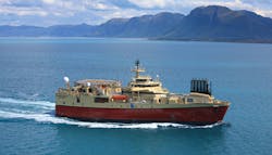
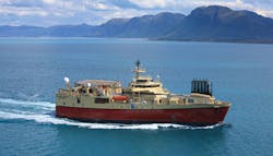
TGS and Petroleum Geo-Services have allocated a second vessel, the Ramform Sterling, to the 2018 East Canada acquisition program. This vessel will acquire a minimum 2,700 sq km (1,042 sq mi) of 3D seismic, including additional data within the 2017 Harbour Deep and Cape Broyle 3D survey outlines. Acquisition is expected to be completed in 3Q 2018.
Pre-processing of the initial GeoStreamer signal will be performed by PGS onboard the Ramform Sterling, following which TGS will perform data processing using its Clari-Fi broadband technology. Fasttrack data will be available in 1Q 2019 with final data in 2Q 2019. This project is supported by industry funding.
The Ramform Sterling will acquire a minimum 2,700 sq km (1,042 sq mi) of 3D seismic offshore Newfoundland. (Image courtesy PGS)
Following this eighth consecutive season of data acquisition offshore eastern Canada, the jointly-owned library will have more than 175,000 km (108,740 mi) of 2D GeoStreamer data and approximately 40,000 sq km (15,444 sq mi) of 3D GeoStreamer data.
Polarcus to acquire 3D seismic survey offshore northwest Australia
Melbana Energy has contracted Polarcus for the 3D seismic survey over the Beehive prospect in the Joseph Bonaparte Gulf, 225 km (15.5 mi) southwest of Darwin. Santos will operate the survey and co-fund it with Total, pursuant to a recently operations services agreement.
Melbana, which is carried for the program, expects acquisition to start next month and to finish before the end of August. It will cover around 600 sq km (231 sq mi) with a larger operational area around it to allow for vessel turns and testing of equipment. Results should help de-risk the potentially giant Beehive prospect and will simplify selection of the location for the Beehive-1 exploration well.
Schlumberger signs offshore seismic agreement with Sri Lanka
Schlumberger subsidiary Eastern Echo DMCC will acquire, market, and license seismic data offshore Sri Lanka on a multi-client basis, under an agreement with country’s Ministry of Petroleum Resources Development. This will allow various 2D and 3D acquisition programs to go forward in selected offshore areas around Sri Lanka, at no cost to the government.
Eastern Echo DMCC has committed to invest a minimum of $50 million in the project, which will include advance data processing/interpretation work or modeling of petroleum, depending on the country’s requirement and pre-commitments to be secured by the contractor. The company expects to recover its costs from sales of the proceeds to clients.
According to the ministry, the main aims of the accord are to acquire more petroleum data using modern acquisition and processing techniques, thereby reducing the technical and financial risk to parties considering deepwater exploration off Sri Lanka, and to encourage an increased level of investor participation in oil and gas exploration activities.
Also covered under the agreement is the provision of training on petroleum systems modeling and interpretation of the new data. Further integration with, and updating of, the existing geotechnical database should increase understanding of the sub-surface.
In addition, the government will receive a share of future data sales revenue either in cash or structured competency development programs/software from Schlumberger.
CGG completes 3D survey ahead of Mozambique licensing round
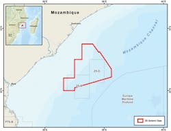
CGG has acquired 15,400 sq km (5,946 sq mi) of 3D marine seismic data over the outer Zambezi Delta basin offshore Mozambique, west of the Beira High. The survey area covered blocks Z5-C and Z5-D and surrounding open acreage.
It was the first survey following an agreement CGG signed last year with the country’s Instituto Nacional de Petroleo (INP) concerning a new multi-client acquisition program.
Location of CGG’s recently completed 3D survey over the Beira High in the Zambezi Delta. (Map courtesy CGG)
The company expects the fasttrack PreSTM data set to be available during 4Q 2018 ahead of a license round next year, and will issue final PreSDM deliverables in 4Q 2019, along with a complementary JumpStart integrated geoscience package.
CGG CEO Sophie Zurquiyah said: “This advanced 3D survey is being imaged with our latest subsurface imaging technologies.
“Combined with our JumpStart integrated geoscience program, regional coverage from our 2017 East Africa Robertson study, and the Robertson New Ventures Suite, it will support INP’s promotion of the potential in the deepwater Zambezi Delta basin and the west flank of the Beira High.
“This full package will also provide interested industry companies with the information required to confidently de-risk the full Paleozoic, Mesozoic, and Cenozoic series in this exciting new exploration area.”
Sercel’s QuietSea integrated passive acoustic monitoring system was deployed on the survey vessel for monitoring of marine mammals in the environmentally sensitive Mozambique Channel.
In addition, CGG has completed pre-stack time migration (PSTM) of its 2,500-sq km (965-sq mi) Dunquin multi-client survey, which the company acquired last summer over block 44 of the Porcupine basin offshore western Ireland.
This is the latest in a series of multi-client surveys CGG has acquired in the area, where it now has 10,500 sq km (4,054 sq mi) of 3D and around 2,000 km (1,243 mi) of long-offset 2D broadband data.
The company delivered PSDM products for its 2016 Galway and Cairenn surveys last year. As with these exercises, the Dunquin data will be processed using advanced velocity modeling and depth imaging, following industry funding.
According to CGG, the initial results reveal important details of the carbonate reservoir that forms the Dunquin structure.
Luc Schlumberger, EVP, Multi-Client & New Ventures, CGG, said: “Our new Dunquin data set…will enhance industry understanding of potential areas of interest in this still unexplored region.”


