3D seismic delivers presalt imaging offshore South Gabon

Surveys have revealed structures never seen before
Neil Hodgson
Karyna Rodriguez
Spectrum Geo Ltd.
In the first five months of 2017 the ground work for a miracle was built over the shallow waters offshore South Gabon.
For over 50 years, oil explorers have been fighting with complications in the geology that have made the oil bearing sequences in this area virtually unresolvable on seismic data. The technical problems were numerous and geologically stacked on top of each other – a hard seabed, and a complex set of rocks varying vertically and deposited on a salt unit which is itself both highly variable in thickness and composition. These create, as we shall see, every sort of difficulty for seismic processing. Taken together, they pose a complex problem for geophysicists to unravel. Indeed, this challenge was thought impossible to overcome until recent evolutions in integrated seismic planning, acquisition, and processing provided tools sophisticated enough to tackle this problem.
Last year, Spectrum undertook the biggest multi-client 3D seismic survey ever acquired offshore Gabon, over an area of greater than 11,000 sq km in a range of water depths from 20-1,000 m. (All images courtesy Spectrum Geo Ltd.)
Because of the challenging seismic environment, many wells have been drilled in this area on prospects defined by geological models, or gravity data – or a wing and a prayer. There has been success in the past: our exploration predecessors were cunning and inspired in equal measure, and a lot of oil has been discovered in sandstones of the Gamba Formation that lie just beneath a ubiquitous regional seal and below a salt unit. But Spectrum believed there was much more to be found in deeper plays below the Gamba Formation.
In 2017, in collaboration with the Gabonese Hydrocarbon Authorities (DGH), Spectrum undertook the biggest multi-client 3D seismic survey ever acquired over these shallow waters – over and area of greater than 11,000 sq km offshore of Mayumba and Sette Cama, west of the Olowi field, in a range of water depths from 20-1,000 m.
The first results from the survey are stunning the industry, as for the first time the presalt oil-prone sequences are imaged – which is incredible enough, yet this has also already revealed a large number of structures never even suspected before, including new oil trapping configurations (also called “plays”). When the final stage of processing the data is complete in May, this area will be drill-ready for a new generation of explorers to be unleashed on it – and bring in a new oil creaming curve for value for Gabon.
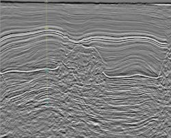
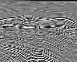
Above: Full volume PSTM over the Muruba Marine-2 discovery well. The Dentale and the Muruba structure is imaged in great detail. Below: Test Sub-cube PSDM showing fantastic imaging of the Dentale pre-salt syn-rift reflectors and structures, including resolving base salt and base Gamba Horizons.
South Gabon geology
For many years, the accepted exploration target in South Gabon has been simply the presalt high quality sandstone of the Gamba Formation. This sandstone was deposited when marine waters first inundated the great rift that was breaking a super-continent (Gondwana) in two, a process that gave birth to the Atlantic. When rifting had started in the earliest days of the Cretaceous Period, the rift was a connected series of depressions, some bearing great lakes and others rivers and swamps yet the whole rift drew in sediments lands around the rift and became part filled with sands and shales. An environment similar to the great rift cutting through East Africa today is envisaged – yet with rather more dinosaurs. Just like today, the lakes along the rift tended to have anoxic waters at depth – poisonous to life but excellent for preserving any organic material that falls into it. In this way the lake sediments deposited as the rift formed (called the syn-rift) have many layers rich in organic carbon that when heated, generate oil. In Gabon, these are the Melania and the Kissenda source rocks. Also, the syn-rift has also preserved many types of sandstone sediments, some deposited in rivers, some alluvial fans and also within the lakes – in sandy deltas at the lake margins and as sandy fans on the lake floor. These sandstones are the target reservoir of the syn-rift and are known as the Dentale Formation sandstones.
As the rift grew and grew and eventually the continent split apart, then the first marine waters rose over, or transgressed, the syn-rift sediments. As it did so, the syn-rift sediments were eroded, worn and the sediments reworked. The result of this was a surface that is almost planar, worn away by the transgressing sea, and a thick beach sediment – some 30-40 m was deposited almost everywhere, and is now what we call the Gamba Formation. As the transgression continued eastward across what is now onshore Gabon, the more distal sediments deposited in that early sea were mudstone, which is now found on top of the Gamba sandstone. This mudstone is known in Gabon as the Vembo Shale Member, and is only 30-40 m thick, yet is probably what keeps oil generated in the syn-rift and migrating up into the Gamba sandstones from escaping – i.e., it is providing a regional seal.
Until recently the seismic below the salt had been so poor that the sands in the syn-rift below the Gamba could not be imaged in traps and so, although they were recognized to be present, they were rarely targeted. We knew that although the technical challenges were immense, the potential reward was to re-invigorate exploration in shallow water offshore Gabon.
The main reasons for the historically poor-quality data in this area was not the geology of the presalt, but the geology of the postsalt. In many places along the South Atlantic, rift salt units are found of exactly the same age. Salt deposits form when bodies of sea water become isolated from the global ocean and the sea water evaporates increasing salinity until salt crystals form and accumulate on the sea bed. Such a situation occurred in many of the South Atlantic basins forming at this time. Apart from the geological curiosity and the potential for another regionally sealing sequence to be found above the syn-rift, the salt is important because it deforms and flows plastically when loaded. In this case, almost as soon as the basin re-connected to the global ocean, limestone started depositing near to shore. Large carbonate platforms formed, and as these are very dense, they immediately started to deform the underlying salt layers. This not only contorted the salt into walls and pillars called diapirs, but the depositional systems on the platforms and the platform margin edges also became incredibly locally complex. For this reason, the post-salt section is highly variable laterally – limestones of the Madiela Formation grade into mudstones in a highly complex manner, and rapid changes to the location of these transitions through time means that the variability is vertical and well as lateral. This makes a 3D model of the geology like an intricate weaving of very dense limestone and less dense mudstone. As density and seismic velocity are related properties, this gives seismic waves an extraordinarily complex path to travel – and processing this seismic, removing noise and multiple requires an intimate knowledge of the velocity field. This really was beyond previous technologies and explains the poor imaging of historical 2D and 3D data in this area.
The solution
The first stage of this challenge was to undertake a detailed technical optimization of our 3D acquisition plan. We knew that if we acquired good data, we could then apply cutting edge processing to provide unique imaging of this exciting potential. Spectrum’s strategy to acquire good quality imaging of the presalt syn-rift was to integrate optimized acquisition and processing technologies. To ensure that the acquisition was optimized, we modeled the likely behavior of the seismic waves as they encountered the geology both above and below the salt to ensure that the seismic acquistion had the best chance of capturing reflected energy. Yet, this itself is not straightforward as it entails assessing the seismic velocity – the speed of seismic sound waves passing through the rock layers.
As input data to the acquistion model, previously drilled wells is the primary source of hard data. Fortunately the wells made available by the DGH tied into legacy 2D seismic. Additionally, older 3D seismic in the area was made available by DGH for mapping the gross sequences to help us model seismic ray paths. The final structural velocity model was created out of 10 layers, from the seafloor to three subsalt targets located respectivelly at depths reasonable for the syn-rift plays Spectrum identify.
After this, the seismic properties of the salt and post-salt carbonate were modified to encompas the uncertainty that exisits when trying to predict these properties in the subsurface. The model was then used to generate ray tracing solutions which effectively predicts the amount of seismic energy likely to be recorded under different shooting directions, and with different seismic streamer and source configurations. The modeling approach for seismic stacks based on an efficient numerical workflow, which creates statistical ray paths solutions to evaluate the 3D illumination at defined targets (Cvetkovic et al. 2014).
Combined 3D and 2D finite difference modeling with raytracing based attributes allows us to quickly turn-around a robust analysis of different scenarios or models from the acquisition, to optimize the ranges of maximum offsets, near offsets, record lengths, source and receiver sampling. In order to get more realistic seismic shot records, we added random and coherent noise to the ray-tracing model, and each set of synthetic shot-gathers were migrated using Reverse Time Migration (RTM), an uncompromised imaging algorithm that will honour steep dips and complex overturned structures.
The results showed that seismic streamers at least 7 km long would be required to image the syn-rift; interestingly most previous 3Ds had been acquired with 4-6 km streamers. To ensure that we collected enough data, we finally elected to acquire data with 8 km long streamers. The modeling also showed that due to the heterogeneous salt and post-salt carbonate geometry, the shooting direction for the survey was unlikely to be an issue. Therefore, a coast-parallel orientation, which optimized efficiency and coverage of the area and ensured that line turns could be made in a safe and efficient way, was chosen.
The seismic survey was acquired in seven months by two separate vessels: one operating in shallow water depths ranging from 28 m to 50 m towing a spread of six streamers, 8 km streamer length with 100 m separation, this configuration was maintained for approximately 2,500 sq km; and one vessel acquiring in water depths ranging from 50 m to 800 m towing a spread of 12 streamers, 8 km streamer length, with 100 m separation covering an area of approximately 9,000 sq km.
The streamer tow depth of 17 m was achieved by both vessels and enabled recording to the very low frequencies required for subsalt imaging, allowing for optimal broadband processing and to enhance potential low frequency seismic facies in the presalt units. Ultimately, the survey was planned in such way that seismic interference was avoided without affecting efficiencies of the survey operations. After the data was acquired, it has been processed by Down Under Geophysical, specialists in complex large 3D processing. The data were processed through a Pre-Stack Time Migration (PSTM) sequence by December 2017, and are currently being migrated in the Pre-Stack Depth (PSDM) domain, which should be complete by May 2018. Key to this process is the definition of the velocity field, discussed above for modeling. A number of horizons are interpreted to constrain the PSDM velocity tomography, and a number of processing techniques used to eliminate noise and multiple. Details of this technology will be released shortly.
Results
Two images are included here that indicate the power of this new data to image the pre-salt. The first is taken from PSTM data and is a line over the Muruba Marine discovery in the centre of the area. The Muruba Marine 2 well was drilled by Total in 1981 and discovered light oil in syn-rift Dentale Formation sands some 400 m below water wet Gamba sands. The well tested at apparently commercial flow rates, however, even on 3Ds acquired over this in the early 2000s, the oil-bearing horizons were not imaged, such that it has always been extremely difficult to estimate the potential resource level for this discovery. It remains undeveloped. However, the new PSTM data not only images the Dentale Formation through the well, but also shows the trapping fault for the discovery to the west. This extraordinary result suggests that the time has come for the re-assessment and exploitation of this discovery.
The second image is taken from a small forward testing cube only 500 sq km in extent, extracted from the full 11,500 sq km survey. The sub-cube has been processed to a closer to final PSDM level to test the approach and processing flow. Imaging presalt is extraordinary with its imaging of the syn-rift, and reveals structures that have little or no expression at Gamba level – so they have not been tested by accident. They also demonstrate an intra-syn-rift complexity not imaged before which will set up plays that have several potential source rocks charging fluvio-deltaic sands in completely untested traps, in a play that could not be imaged prior to this survey. Undertaking the sub-cube processing has yielded a number of key insights into the optimal processing flow which have been introduced into the full volume PSDM processing flow.
We estimate that the 500-sq km test cube has at least eight large untested structures with significant, commercial resource potential in each. If this is indeed replicated across the full 3D volume, there could be over 100 oil-bearing structures in the shallow water acreage below the 3D that have never been targeted (except for Muruba Marine-2 which was a discovery – albeit enigmatic until now).
This new data suggests that integrated planning, operations, acquisition and processing, where care is taken in each step and seemingly intractable technical problems are identified, attacked and solved is the solution for this long-time problem seismic area, and more-so, that such an approach in future will make imaging the impossible – possible.
Acknowledgements
The authors wish to the Gabonese Hydrocarbon Authorities, Direction Generale des Hydrocarbures for their invaluable support and assistance during the planning, acquisition phases of this successful project.
References
Esestime, P., Arti, L., Cvetkovic, M., Rodriguez, K. Hodgson, N. [2017] 3D Shallow Water Seismic Survey Planning to Deliver Sub-Salt Imaging in South Gabon. First Break, 35, 85-89.