PGS promoting latest datasets offshore Nigeria, northern UK
Offshore staff
LYSAKER, Norway – PGS’ UK imaging center aims to deliver first results this spring from a re-processed multi-client 3D (MC3D) pre-stack depth migration (PSDM) dataset offshore Nigeria.
This will cover the newly relinquished blocks OPL321 and OPL323, also integrating data acquired in 2004 over blocks OPL314 and OPL315.
The MC3D OPL 314/315/321/323 spans the area between the Benin Embayment and the Benue Trough, and should assist integrated exploration of the northern and eastern Gulf of Guinea.
PGS says the area has numerous similarities to the joint development area and offshore São Tome & Principe, southeast of the Niger Delta. Here large dextral regional transform faults such as the chain transform zone exert a major influence on the tectonic regime.
The northern shoulder of the Niger Delta, the company adds, contains almost all the regional structural domains associated with shale tectonics in the region, barring the deformed and thrusted shale diapiric domain.
Between the 1990s and last March, many fields were discovered to the south and east, including the giant Bosi (1996), Erha (1999), and Oyo North (2018).
The most recent exploration identified at least eight prospects within this petroleum system with potentially billions of recoverable barrels of oil over blocks covered by the present depth-reprocessed survey.
Numerous deepwater channel complexes and shale-cored folds of multi-kilometric scale extend throughout the survey area forming the cornerstones of the Post-Akata exploration.
Post and Sub Akata play evaluations should benefit from the new structural analysis, PGS added.
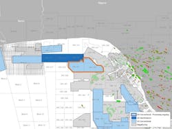
The company has also made available fasttrack 3D data for the forthcoming Supplementary Licensing Round in the UK’s Outer Moray Firth, Greater Buchan Area off northeast Scotland.
This is said to provide a substantial broadband uplift to improve understanding of the potential in the area. The Oil and Gas Authority estimates reserves in the range of 150-300 MMboe.
PGS’ data comes from its new, high-density 3D GeoStreamer Moray Firth survey, over potential plays from a fractured basement to shallower Cretaceous targets.
The survey, acquired last year, covered nearly 7,400 sq km (2,857 sq mi).
Imaging of the Moray Firth is complicated by the masking of deep structures through a combination of shallow water and complex shallow overburden.
However, PGS has applied a complete wavefield imaging workflow which, the company says, resolves the shallows and reveals the deep, with the GeoStreamer multi-sensor technology processing and imaging all recorded wavefields using reflections, refractions, and multiples.
01/31/2019