CGG completes 3D survey ahead of Mozambique licensing round
Offshore staff
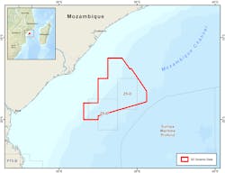
MASSY, France – CGG has concluded acquisition of 15,400 sq km (5,946 sq mi) of 3D marine seismic data over the outer Zambezi Delta basin offshore Mozambique, west of the Beira High.
The survey area covered blocks Z5-C and Z5-D and surrounding open acreage.
It was the first survey following an agreement CGG signed last year with the country’s Instituto Nacional de Petroleo (INP) concerning a new multi-client acquisition program.
The company expects the fasttrack PreSTM data set to be available during 4Q 2018 ahead of a license round next year, and will issue final PreSDM deliverables in 4Q 2019, along with a complementary JumpStart integrated geoscience package.
CGG CEO Sophie Zurquiyah said: “This advanced 3D survey is being imaged with our latest subsurface imaging technologies.
“Combined with our JumpStart integrated geoscience program, regional coverage from our 2017 East Africa Robertson study, and theRobertson New Ventures Suite, it will support INP’s promotion of the potential in the deepwater Zambezi Delta basin and the west flank of the Beira High.
“This full package will also provide interested industry companies with the information required to confidently de-risk the full Paleozoic, Mesozoic, and Cenozoic series in this exciting new exploration area.”
Sercel’s QuietSea integrated passive acoustic monitoring system was deployed on the survey vessel for monitoring of marine mammals in the environmentally sensitive Mozambique Channel.
06/13/2018
