GEOSCIENCES
Variety of new software hits the geosciences world
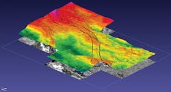
In addition to the CGG GeoSoftware update noted with the accompanying screen shot, there are a number of other new geophysical software advances made available over the last few weeks.
Paradigm has released Paradigm 15, its latest version of its software suite that aims to increase user productivity. Designed to foster cost optimization, Paradigm says Paradigm 15 can enhance earth models and properties and give more accurate positioning of reservoirs at depth with a global mis-tie determination and correction. It also has new quantitative seismic interpretation packages designed for interpreters and reservoir geophysicists and can provide complex, geologically constrained velocity determination and model building base on integrating SKUA-GOCAD and GeoDepth.
As is the trend, Baker Hughes has released JewelSuite 6 integrated reservoir modeling software for use with not only geological modeling and reservoir engineering, but also geomechanical modeling and reservoir stimulation. Baker Hughes says the geological modeling and reservoir engineering application can build accurate models and run multiple scenarios in complex reservoirs to help determine an economically viable development plan. The geomechanical modeling can help in predicting drilling and production problems and developing mitigation solutions.
CGG GeoSoftware also has released Jason 9.0 reservoir characterization program. New tools and upgrades include anisotropic inversion of azimuthal seismic surveys, nuclear magnetic resonance log interpretation, pore pressure analysis, and acoustic log interpretation. Jason 9.0 also has a new integrated platform to allow sharing of well information and seismic and geostastically derived lithology information across the seismic-to-stimulation workflow.
Seismic programs in progress, in planning
TGS has completed an initial survey in the southeast Barents Sea, and has elected to extend its charter with Polarcus to acquire a further 3,000 sq km (1,158 sq mi) of multi-client 3D seismic in the Norwegian Barents Sea. The initial letter of award contained a potential extension of as much as 7,000 sq km (2,803 sq mi).
Polarcus and TGS-NOPEC also have signed a letter of intent for the charter of a 3D vessel for an estimated six-month period in 2016 for a number of projects. Under the terms of the LOI, TGS will offer Polarcus the right of first refusal for the charter of 3D vessel capacity to acquire discrete projects totaling as much as 10,000 sq km (3,861 sq mi).
Chevron is reported to be in the process of interpreting data from its seismic survey of deepwater off south Australia in the Great Australian Bight. The report says TGS collected more than 22,000 sq km (8,494 sq mi) of data. The Bloomberg report also says Ion Geophysical is planning a seismic program for 4Q 2015 also off southern Australia. BP completed a seismic program in the area three years ago and is looking toward drilling in 4Q 2016. •


