NPD commissions frontier Norwegian Sea subsurface mapping
Offshore staff
OSLO, Norway – Fugro Seacore’s Greatship Manisha will sail from Kristiansand this May to perform subsurface mapping in the Norwegian Sea for the Norwegian Petroleum Directorate (NPD).
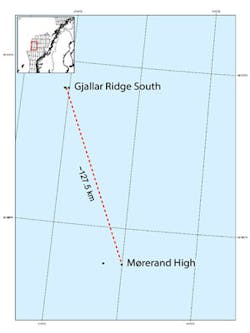
The vessel will map unexplored acreage on the Mørerand High and Gjallar Ridge South on the western part of the continental shelf. It will drill up to 200 m (656 ft) below the seabed to rocks formed around 55-65 million years ago during the Cretaceous and Palaeocene periods.
“Geologically speaking, this is a blank spot on the map,” said NPD project manager Nils Rune Sandstå. “The objective of thedrilling is to learn what kind of rocks can be found there, and how old they are.”
The target on the Mørerand High (49 mi/79 km west of Mosjøen) is near where the continental plates separate from the oceanic crust to the west. Material from this area should improve understanding of the Møre basin for future exploration, Sandstå added.
On the Gjallar Ridge South, the vessel intends to sample thegeological layer above those examined by NPD last summer using an ROV.
The program is part of an ongoing mapping exercise of the sea area betweenNorway and Greenland. This year’s fieldwork should answer questions such as whether some of the rocks are sedimentary or volcanic.
05/02/2014