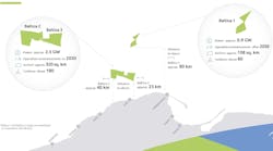
Brian WickensPlanned Offshore Developments [56113801.gif - 11k]
Contributing Editor - Perth
Western Australia's Northwest Shelf [56113601.gif - 71.27 K]
Offshore development projects may be slow in getting off the ground in Australia but the State of Western Australia holds some of the country's most prospective and underexplored exploration acreage. This was highlighted in the recent offshore gazettal round with 22 of the 38 blocks released in Western Australian waters.
While Australia is enjoying its highest levels of oil and gas production ever, the country is far from experiencing an oilfield development boom. Although there are a number of planned offshore developments just around the corner, local infrastructure has little else to do in the meantime but wait. Australia holds some highly prospective, underexplored exploration acreage but much of it is in deeper waters and requires deep, well lined pockets to fund the exploration budgets. Consequently the petroleum industry has been consolidating. Woodside and BHPP have recently been through downsizing exercises, Ampolex has been sold to Mobil, WMC Resources and MIM are selling up, Enterprise is moving out, and West Australian Petroleum (WAPET) is currently undergoing a review of its operations with a view to reduce operating costs by around 25%, commencing in the 1997 financial year.
Declining production and no immediate prospects to come onstream is WAPET's reason for reducing its operating costs, whereas others, such as WMC Resources, see better returns elsewhere. The company has decided to sell off all its Australian and overseas oil and gas assets, bar the 62.7% share in the Western Australian Goldfields Gas Transmission (GGT), valued at up to A$400 million. A spokesman for WMC Resources said that while the petroleum division was viewed as having good strategic assets and skills, the requirement for exploration funds and capital, at a time of major expansion of other projects, has led to the decision to sell.
The consolidation should not, however, be seen as the beginning of the decline of Australia's oil and gas industry. While the development sector is nervously awaiting the announcement of the country's next project go-ahead, the exploration sector is as busy as it has ever been.
Following the latest offshore gazettal round there is considerable local and international interest in the acreage on Australia's western and northern seaboards, in particular the North West Shelf and Timor Sea. In June 1996, the Australian Government released 38 offshore areas for exploration under its work program bidding system of which 22 are in Western Australian waters (W96-1 to 22); six in the waters of Territory of Ashmore and Cartier Islands (AC96-1 to 6) and four in Northern Territory waters (NT96-1 to 4).
The release of these areas, the first for 15 months, has the service sector flat out supplying interested parties with existing data and acquiring new data for bids to be completed by the 30th January 1997 deadline.
The Western Australian areas include shallow and deepwater acreage and much of it adjacent to existing and recent major oil and gas discoveries.
The 1995 Gwydion-1 oil discovery opened up an eastern basin margin oil play in the Browse Basin where 8 areas, W96-1 to 8, have been released in water depths of 40 to 200 m. Although the gas potential of the Browse Basin has long been known - the Scott Reef gas field, discovered by Woodside in 1971, is Australia's largest known gas accumulation, and there are other gas and gas/condensate discoveries and shows in the basin - the oil potential of the basin has not been understood. Oil shows had previously been seen at Yampi-1 well and a small oil recovery made from Caswell-2 well, but the discovery of oil in Gwydion-1 on the Yampi Shelf demonstrates the potential for long range migration of oil generated in the depocentres, and has clearly upgraded the prospectivity of the region.
Exploration targets in Areas W96-1 to 8 are anticipated at depths of less than 1200 m in marine Lower Cretaceous sands draped over basement highs and there is additional stratigraphic trap potential including pinchouts against such highs. Cretaceous shales have good seal potential and seismic data quality is good.
On the Exmouth Plateau, seven areas are offered, W96-9 to 15, in water depths of 900 to 2000 m. Area W96-10 is adjacent to the Scarborough gas field and comprises nine blocks, the remaining areas comprise between 68 and 180 blocks. Exploration in the late 1970s and early 1980s saw the discovery of the as yet undeveloped giant Scarborough gas field, and most of the wells drilled in adjacent areas have recorded hydrocarbon shows and some have recovered petroleum on test.
Prospective reservoir sections may be present in fault blocks containing Upper Triassic fluviatile Mungaroo Formation sands together with Jurassic-Lower Cretaceous basin floor sands and shallower deposits. Seals occur at several horizons through the Jurassic and Cretaceous sections and there is a regional Cretaceous seal provided by the Muderong Shale and its equivalents. Hydrocarbon charge is expected from the Triassic Locker Shale and Jurassic euxinic mudstones.
Areas W96-16 to 19 comprising between six and 10 blocks, overlie the Alpha Arch, a northeast trending structural high located in the southwestern Barrow Sub-basin, and the focus of significant hydrocarbon accumulations. Adjacent to the areas are the giant Gorgon gas field, the Chrysaor, West Tryal Rocks, Spar, and East Spar gas and gas/condensate fields, the Griffin/Chinook/Scindian oil, gas, and gas/condensate complex, and the Pyrenees/Macedon oil and gas fields.
Potential source rocks include the Triassic Locker Shale and Jurassic euxinic mudstones (principally the Dingo Claystone) in both the Barrow Sub-basin to the east and Exmouth Sub-basin to the west. Prospective reservoir sections may be present in the Upper Triassic fluviatile Mungaroo Formation sands and/or deltaic to marine/marginal marine sands of the Lower Cretaceous Barrow Group (Birdrong and Zeepard Formations). Seals occur at several horizons throughout the Jurassic and Cretaceous section with an excellent regional seal provided by the Cretaceous Muderong Shale. The main oil and gas plays are likely to be Neocomian deltaic units and pre-breakup Triassic-lower Jurassic sand reservoirs. Stratigraphic leads within the Cretaceous and Jurassic section and structural leads below the regional seal have also been recognized in the release areas.
Farther south in the Exmouth Sub-basin, is the very lightly explored Area W96-20 in water depths ranging from 200 m to greater than 1000 m. Possible source rocks include the Triassic Locker Shale and Jurassic Dingo Claystone. Reservoir sections may be present in Upper Triassic fluviatile Mungaroo Formation sands and/or Upper Jurassic-Lower Cretaceous deltaic sands. The Cretaceous Muderong Shale provides an excellent regional seal, with several other horizons within the Jurassic and Cretaceous sections also providing potential seals. Oil has been discovered in the pre-breakup section in the northeastern part of the Exmouth Sub-basin, and recently, the Pyrenees and Macedon oil/gas fields were discovered on the northeastern margin of the Barrow Sub-basin.
In the northernmost part of the Carnarvon Basin, Area W96-21, comprising 94 blocks, lies on trend with the Rankin Platform oil and gas fields and west of the Middle Jurassic Nebo-1 oil discovery. Water depths range from 100 m in the southeast to over 1000 m in the northwest. Source rocks have been identified in the Lower-Middle Jurassic Picard Shale and Late Jurassic to Neocomian claystones. The Triassic Locker Shale may also have source potential. Potential reservoir units occur as basal sands in the Lower Triassic Locker Shale, and Triassic-Middle Jurassic Mungaroo, North Rankin, Brigadier and Legendre Formations. Upper Jurassic to Neocomian marine claystones provide a regional seal, and numerous intraformational seals are present throughout the sequence. The main plays are structural traps below Cretaceous regional seal and structural/stratigraphic trapping within the Jurassic section. Nebo developed as a combination of faulting during mid-Jurassic breakup and arching associated with Neocomian wrenching.
Area W96-22 comprises 87 blocks lying offshore southwest of Perth in the Vlaming Sub-basin. Water depths range from 20 m to 2000 m, but for the large inshore part of the area water depths are generally less than 50 m. Oil and gas are produced from the onshore part of the basin but not offshore, although oil was recovered from Gage Roads-1 adjacent to Area W96-22. Potential source rock intervals capable of oil generation have been identified in the Middle-Late Jurassic Yarragadee Formation. The Early Cretaceous Parmelia Formation also contains potentially good source rocks. The main part of the sub-basin comprises Jurassic to Cretaceous clastic sediments interrupted by Neocomian rifting and an associated major unconformity. A recent review of the basin confirmed or identified play concepts and leads associated with unconformity closures, drapes and pinchouts, and sub-unconformity fault traps, as well as a Lower Tertiary channel play. There is an extensive amplitude anomaly associated with a unit immediately overlying the Neocomian unconformity.
Copyright 1997 Oil & Gas Journal. All Rights Reserved.


![Planned Offshore Developments [56113801.gif - 11k]](http://images.pennwellnet.com/ogj/images/off/56113801.gif)
![Western Australia's Northwest Shelf [56113601.gif - 71.27 K]](http://images.pennwellnet.com/ogj/images/off/56113601.gif)