Editor's note: This article first appeared in the July-August 2023 issue of Offshore magazine. Click here to view the full issue.
By Jeremy Beckman, Editor, Europe

The idea for the development arose from a conversation between Perth, Australia-based Blue Ocean Monitoring, a specialist in autonomous technologies for marine data acquisition, and client Woodside Energy. Woodside was interested in extending the role of autonomous underwater gliders supplied by a third party for marine mammal monitoring to seismic data acquisition. Woodside/Blue Ocean decided to co-fund their own development, with bp Ventures subsequently coming onboard. This led to the formation in late 2019 of Blue Ocean Seismic Services, based in Farnborough, England, which has managed all the design, engineering and prototype construction for the development.
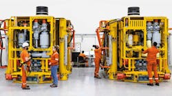
Traditionally, ocean bottom nodes (OBNs) equipped with geophones and hydrophones are positioned at the seafloor location using an ROV launched from a specialist vessel: the alternative is ocean bottom cable deployments from a diesel-powered vessel, towed on a designated track line at traveling speeds of 2-5 knots, but restricted in terms of water depths and environmental conditions. Both options can be energy-intensive and relatively high cost because of the associated vessel spreads and crew requirements: Blue Ocean claims its technology can cut seismic survey costs by more than 50% through reduced survey times and dispensing with the need for specialist exploration vessels. The approximately 1-m long Blue Ocean nodes can be launched in water depths down to 2,800 m from any vessel of convenience, traveling autonomously underwater to position themselves at pre-determined locations, acquiring data at set intervals and for set periods before lifting off to `fly’ to new locations. They are designed to operate continuously for three months submerged before retrieval for wireless re-charging and data transfers.
Initial engineering at Farnborough led to development of the prototype tOBSrV test vehicle and associated communication, command and control system (C3), combined with Blue Ocean-developed electronics, communications systems and control software. At that stage, the focus was on using the tOBSrV for in-water testing of the electronics and software, providing a platform to speed up development of both while at the same time progressing design and manufacture of the hardware components.
During the initial sea trials in Perth in 2021, the tOBSrv achieved all main objectives, traversing a series of waypoints while at the same time issuing status updates to the host vessel, and logging flight and engineering data for use in the next phase of systems development and optimization. The program successfully demonstrated early-stage tracking and control user interfaces and visualization; automated topside USBL acoustic tracking and acoustic message dispatching systems; and external parsing onboard the test vehicle through acoustic message and implementation in navigation control.

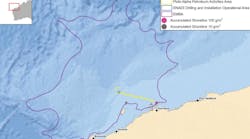
Further trials followed in 2022 of the next-stage alpha vehicles (AP-OBSrV) in Plymouth, south-west England, Loch Ness in western Scotland and Australia to confirm the capabilities of the command and control systems, underwater flight performance, and seismic coupling to the seafloor. Another test program in the southern UK North Sea offshore the port of Blyth demonstrated the vehicles’ capability for active seismic data acquisition alongside conventional OBN nodes, and their ability to maintain a close seismic coupling with the seabed, especially in cross-currents.


In addition, the subsea robots are said to have “outperformed” ROV-positioned nodes which were launched alongside for comparison purposes. “Blue Ocean nodes continued to operate during these conditions,” Illingworth explained, “adapting to currents, adjusting their course and successfully and autonomously repositioning. During previous trials the Blue Ocean nodes collected data of a better seismic quality than traditional nodes. For this trial, passive seismic data was acquired. We are unable to comment on how they increase their weight to the seabed but the vehicle is buoyancy driven. In future, we are aiming for targeting landing accuracy of 1-2 m. USBL positioning technology is water-depth dependent, but we have developed additional technology to improve it including the use of other vehicles acting as reference beacons.
“Broadly the genesis of Blue Ocean Seismic Services was to create the world’s first autonomous, low impact subsea nodes, with the aim of reducing the carbon footprint of seismic data acquisition while significantly reducing survey time and cost. We hope to provide a very attractive alternative to the current methods of seismic data acquisition, both from an economical and environmental perspective for carbon capture and storage (CCS), wind farms, and hydrogen monitoring, as well as the oil and gas industry. Marine seismic is a key component of planning and monitoring offshore CCS. The same applies for seabed-based wind farms but only the first 300 m or so of seabed.”
Currently, marine seismic data acquisition remains heavily dependent on technology developed over half a century ago, he noted. “Streamer cables are laid from the aft of a diesel-powered vessel and towed on a previously designated track line traveling at 2 to 5 knots. This is not suitable for many locations and environments. The main alternative, ROV-positioned Ocean Bottom Nodes, is very costly and both solutions are carbon-intensive. Using an ROV requires the nodes to be placed on the seabed: through their ability to autonomously reposition, Blue Ocean Seismic Services nodes significantly reduce the duration and therefore cost and environmental impact of any given survey, and this is our ultimate selling point.
“Charging functionality is provided via an induction system – the nodes are not opened to recharge or to download seismic data. We have not had any major malfunctions to date. Some limited spares are carried. We are planning an inventory of many thousands of nodes: bp itself has spoken publicly about using the nodes in these quantities as part of their Sustainable Seismic initiative.”
The technology is designed to be mobilized globally as a fully containerized solution providing a turn-key option, he continued, “with no special vessels required for deployment. We have had preliminary discussions with autonomous vessels owners as a further lower-cost option for launching purposes: we do not plan to own or operate our own vessels (autonomous or otherwise), however our system is far less onerous in terms of the requisite vessel size, crew and cost than those used for ROV deployed OBN.
“The timing for the commercial launch remains tied to our technology road map, but we are of course hopeful that there will be plenty of demand for it. We are unable to comment on specific operations by our backers, however we expect our first commercial deployments will be for one of our shareholders.”