Gene Kliewer • Houston
WesternGeco reports first-ever dual coil survey
WesternGeco has started acquiring the Revolution multi-client survey in the Gulf of Mexcio. This is the first time that Dual Coil Shooting multi-vessel full-azimuth acquisition has been done commercially, says WesternGeco.
The GoM East Breaks and Garden Banks survey will cover more than 130 outer continental shelf blocks.
The FAZ Dual Coil Shooting is a new way to acquire ultra long offset marine seismic data using four vessels following a circular path. This acquisition provides better target illumination in challenging environments by enabling greater azimuthal coverage and a higher signal-to-noise ratio, says WesternGeco. Dual Coil Shooting technology is possible due to the capabilities of the Q-Marine point-receiver seismic system.
WesternGeco will apply the latest seismic data processing techniques to this survey, including true-azimuth 3D Generalized Surface Multiple Prediction (3D GSMP) and anisotropic reverse time migration (RTM).
Valhall LoFS phase complete
WGP Exploration Ltd. says it has completed the No. 12 Valhall Life of Field Seismic survey on time and on budget. TheM/V Stril Myster is demobilized and back with BP as a supply vessel.
The Valhall platform sets the stage for continuation of a life of field seismic program in the North Sea.
The Vahlall LoFS program began in 2003 when BP installed an ocean bottom cable array and contracted WBP to design the source system. For survey No. 12, Thalassa Energy Services Ltd. provided the source sub-arrays necessary to meet project technical standards.
The Valhall LoFS shooting area consists of 179 shot lines spaced 50 m (164 ft) apart with an average shot-line length of 14.2 km (8.8 mi), over 13 permanently installed and trenched receiver lines of GERI OBC. The total number of shots during the LoFS 12 survey was 51,697, an average of 3,730 shots per day.
WGP says the next survey is scheduled to begin in 2011.
Spectraseis patents low-frequency seismic technology
Spectraseis, the leading provider of low frequency seismic solutions to the oil and gas industry, has announced that the US Patent and Trademark Office has issued the seventh notice of allowance for a Spectraseis patent application.
The latest applications pending before the US and European patent offices include Spectraseis’ new generation of powerful imaging condition methods that separate signal from noise to locate fluids in depth.
“Spectraseis’ patent position covers the leading edge of LF research, with our research commitment to developing the best possible signal analysis methods to extract reservoir associated seismic signals from client data providing patentable inventions on a regular basis,” said Rob Habiger, CTO.
Baker Hughes acquires software developer
Baker Hughes reports that its subsidiary has acquired the remaining interest in oil and gas reservoir modeling software developer JOA Oil & Gas BV, which owns and develops software for technical, scientific, and exploration and production applications. Baker Hughes Nederland Holdings acquired 40% of JOA Oil & Gas in 2009.
JOA Oil & Gas is the developer of JewelSuite software, an integrated reservoir modeling tool that uses patented 3D gridding technology to build accurate reservoir models for fields with complex geology. The JewelSuite software platform also provides connectivity between the generated models and reservoir simulators – a capability designed to further improve overall simulation accuracy.
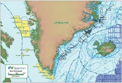
Spectrum has agreed to reprocess more than 7,800 km (4,847 mi) of 2D seismic data offshore the east coast of Greenland with the Geological Survey of Denmark and Greenland (GEUS). This data will be processed though pre-stack time migration and subsequently licensed on a multi-client basis.
The data consists of three surveys known as the NAD project which were acquired in the 1980s. The data is between 62° and 72° north and ties many of the wells drilled by Ocean Drilling Program between 1993 and 1995. Competitive bidding for the area is scheduled in 2012 and 2013, as designated by Greenland’s Bureau of Minerals & Petroleum.
The survey area includes the southern part of the East Greenland rift basins. A 2007 US Geological Survey (USGS) assessment over this province indicated undiscovered oil and gas reserves of 31,400 MMboe. East Greenland forms the conjugate margin to the Norwegian continental shelf, Faroe-Shetland Islands and Rockall basins. It is considered that analogues of successful play types found in these relatively well explored petroleum provinces can be extrapolated into the East Greenland offshore frontier area.
This offshore area is considered an exploratory frontier, with only limited, regional, wide-spaced 2D seismic lines available and only a few ODP wells drilled. Outcrop data from onshore East Greenland and previous interpretation of the existing offshore seismic data suggests elements of a working hydrocarbon system could be present in the area covered by the Spectrum reprocessed data.
Tertiary sediment thicknesses of up to 6 km (3.7 mi) have been postulated in offshore South Eastern Greenland basins (below 72° north) and possible Tertiary and Mesozoic reservoirs could be present in the form of fluvio/deltaic and submarine sandstones. Extensive offshore Lower Tertiary Basalts observed on seismic sections in the northern portion of the study area are almost certain to overlie Mesozoic and Palaeocene sediments.
Offshore Articles Archives
View Oil and Gas Articles on PennEnergy.com


