By Alan Sherwood, Crown Minerals
Recent exploration successes in Taranaki Basin, impressive new data from deep-water frontier regions, and several new evaluations of other hydrocarbon-bearing basins are all contributing to a period of heightened exploration activity in the New Zealand region.
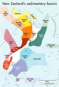
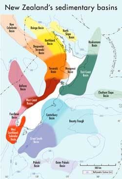
There are a number of sedimentary basins and sub-basins with known or potentially commercial hydrocarbons, both onshore and underlying the continental shelf, as well as several deepwater basins within New Zealand's Exclusive Economic Zone (EEZ). Commercial and sub-commercial discoveries, abundant potential source rocks, thick Cretaceous-Cenozoic sediments, and numerous hydrocarbon seeps and shows in exploration wells are all indicative of viable petroleum systems. New data have also enhanced knowledge of New Zealand's deepwater frontier. Preliminary appraisal suggests that the petroleum potential of several deepwater basins is promising, with considerable scope for giant discoveries.
As exploration and research programs advance, understanding of New Zealand's sedimentary basins and their petroleum systems continues to evolve. The important geological elements of the petroleum systems are now broadly understood. Coupled with increasing levels of exploration over recent years, this has led to an enviable success rate for wildcat drilling and a recent commercial discovery success rate of one in three in Taranaki Basin. Ongoing exploration can be expected to lead to further finds here and in other basins.
Tectonic development
All of New Zealand's known prospective sedimentary basins are younger than Early Cretaceous and most are composite basins, exhibiting multiple evolutionary phases and sediment deposition. The break-up of Gondwana from the Middle Cretaceous and spreading of the Tasman Sea in the Late Cretaceous and Paleocene formed a series of rift basins. Synrift sediments include coarse-grained potential reservoir units and thick coal-rich source rocks.
The Early Paleogene was a period of comparative tectonic quiescence, basin development was characterized by regional post-rift thermal subsidence, and widespread marine transgression led to the deposition of shoreline sands followed by marine silts and muds. These transgressive shoreline systems contain important productive and potential reservoir rocks, while overlying silts, muds, and carbonates form good seals.
The present-day Australian-Pacific plate boundary that runs through New Zealand was initiated at the end of the Paleogene, causing southwestward subduction of the Pacific Plate below the North Island and northeastward subduction of the Australian Plate below the southern end of South Island. During the Neogene, the Alpine Fault evolved to become the primary focus of dislocation between the two plates. More than 450 km of dextral strike-slip motion since the Early Miocene has offset basins that had been adjacent. Since the Middle Miocene, relative plate motion has become more oblique, and the rate of convergence has accelerated. Widespread deformation associated with this tectonism has produced many structural traps.
Taranaki Basin
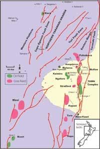
All of New Zealand's oil and gas production so far has been from the Taranaki Basin. Although the basin covers about 100,000 sq km, only 114 wildcats have been drilled since 1955. Now in its fifth decade of modern petroleum exploration, the basin is experiencing an upsurge in drilling activity. Explorers are only beginning to appreciate its multiplicity of plays, and there is increased interest in the more challenging targets.
Numerous superimposed sub-basins, depocenters, and areas of uplift contribute to the complex morphology of the basin, which contains more than 9,000 m of Cretaceous-Cenozoic sediment. All oil, gas, and condensate currently produced is derived from Cretaceous to Eocene terrestrial source rocks with shallow-marine influences, but oils recovered from some subeconomic discoveries have marine sources.
Commercial hydrocarbons have been encountered in every chronostratigraphic level from Paleocene to Pliocene, but have yet to be found in Cretaceous sequences. As a result of the success at Maui Field, Paleogene coastal and estuarine sand reservoirs became important exploration objectives, and the majority of petroleum resources found to date are contained in sandstone and subsidiary carbonate reservoirs of Eocene to Miocene age. Foreland folds and detached thrust sheets along the Tarata Thrust Zone have also been successfully explored. Some small oilfields produce from Cenozoic submarine mass-flow sand deposits, which hold promise of large reserve entrapment in stacked systems.
Exploration has primarily focused on four-way dip closures, horsts, and rotated fault blocks, but not only have these plays not been fully evaluated, many others remain essentially unexplored. Few wells have penetrated the sourcing depocenters, which contain numerous undrilled targets.
The most under-explored region of the Taranaki Basin is the Northern Taranaki Graben. Few wells have been drilled within its 10,000-sq-km area, although many wells around the periphery have made discoveries or had significant shows. The Northern Taranaki Graben is the most promising exploration theater in New Zealand for finding large oil accumulations, according to Wellington-based GeoSphere Exploration. Source rocks are oil prone and mature, and there are well-developed reservoir sequences.
Deepwater frontier
New Zealand has a land area of only 250,000 sq km, but a marine EEZ of 4 million sq km, the fourth largest in the world. This may expand to 6 million sq km as a result of a $20 million marine survey program to delineate the continental shelf under the United Nations Convention on the Law of the Sea.
Most of this vast area of ocean is underlaid by continental crust, within which are a number of sedimentary basins with inferred petroleum generative potential. The total known area of New Zealand's deepwater frontier underlaid by more than 3,000 m of sedimentary rock, is estimated at more than 550,000 sq km.
In 1999, Conoco's drillship Deepwater Frontier spudded the Waka Nui-1 wildcat well in 1,470 m water depth off the west coast of Northland. Although the well was not commercial, this was the first well in New Zealand to be drilled in water depths of more than 1,000 m and marked the beginning of exploring the huge potential of this deepwater frontier.
Recently acquired geophysical data, together with satellite gravity, swath bathymetric, and older seismic reflection data from some of the better-surveyed, deepwater frontier basins, suggest that generation, migration, and entrapment of petroleum are possible in these deepwater basins. Structural and stratigraphic traps are also widespread.
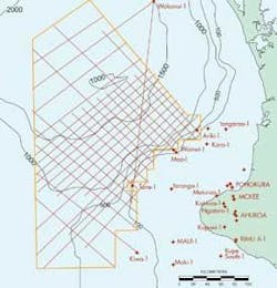
One frontier basin where exploration is sufficiently advanced to allow an initial assessment of petroleum potential is the Deepwater Taranaki Basin, which extends 200 km from the shelf edge out to the 2,000 m isobath and has an area of nearly 60,000 sq km. In July 2001, TGS-Nopec acquired 6,200 km of 2D multi-channel seismic reflection data tied to nine wells on the shelf.
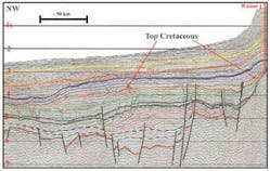
Interpretation of these data by New Zealand-based Institute of Geological and Nuclear Sciences indicates that the Deepwater Taranaki Basin is one of the most attractive frontiers for exploration in New Zealand. Cretaceous strata appear to be up to 5,000 m thick, indicating a particularly large gross thickness of both source and reservoir rocks, typically overlain by a further 2,000 to 4,000 m of Cenozoic strata. Traps are likely to be stratigraphic or structures associated with Cretaceous rifting and Eocene inversion. Basin models, calibrated to the nearby Taranaki Basin wells, predict that expulsion of petroleum from the deepest parts of the basin began in the Late Cretaceous and continues today.
Other basins
Northland: The Northland Basin is one of New Zealand's most under-explored. Only two modern exploration wells have been drilled to date, including the deepwater Waka Nui-1 well. The geology is similar to the Taranaki Basin with which it is contiguous. There is an abundance of very large structural leads and all the elements required for petroleum generation, migration and entrapment are considered to be present.
East Coast Basin: The East Coast Basin is stratigraphically and structurally complex, but multiple reservoirs and numerous large structures offer a range of exploration targets. Eocene and Miocene turbidite sandstone fans, typically 100-400 m thick, are widespread onshore and offshore and are the primary reservoir targets. The accumulation and entrapment of hydrocarbons has been controlled by subduction-related deformation since the Early Miocene, with structures trending parallel to the present day plate boundary, which forms the eastern limit of the basin.
South Wanganui Basin: Several large closures have been seismically mapped in both onshore and offshore areas, and numerous potential reservoir units are present throughout the Pliocene. Only five onshore wells have been drilled in the basin.
West Coast: The onshore West Coast basins have had a long history of exploration, and several oil and gas seeps indicate hydrocarbon generation. The offshore area is virtually unexplored, and a new evaluation by Thomasson International Ventures suggests that offshore basins have promise for world-class giant oilfields.
Canterbury: Canterbury Basin is the northwestern part of a much larger Cretaceous rift of over 200,000 sq km that also includes the Great South Basin and the unexplored deepwater Bounty Trough. Canterbury Basin is geologically similar to the Taranaki Basin and the Gippsland Basin of southern Australia, which were all adjacent during Cretaceous rifting.
Great South: The Great South Basin is the largest of several basins that lie on the Campbell Plateau to the east and south of the South Island. Initial basin formation, with rifting accompanied by deposition of thick coal measures during the late Cretaceous, was similar to most New Zealand basins. However, the Great South Basin differs by a long period of post-Cretaceous tectonic quiescence with little deformation.
There are many undrilled anticlines and drape structures, and stratigraphic traps are essentially unexplored. As for Taranaki Basin, structural traps associated with potential Cretaceous reservoirs have barely been assessed.
Western Southland: The group of onshore and offshore basins in the Western Southland region have good potential, with the few wells drilled regarded as not having adequately tested either their targets or the region as a whole. A recent reevaluation of the Waiau Basin indicates that numerous structural and stratigraphic leads, some very large, are evident in seismic data. The most promising potential source and reservoir unit is similar to productive units in Taranaki, but is more oil prone.
Conclusions
Exploration investment in New Zealand has been growing steadily since about 1996. While Maui Field production and contracts have dominated gas markets for over 20 years, the decline of the field and strong demand means that the market situation is changing rapidly with a looming gas supply shortfall and a likelihood of increased prices. New Zealand has now moved into the top 20 countries in the world for petroleum exploration investment, according to IHS Energy Group's latest ranking, and fourth overall in the Far East-Australasia region.
Since the Kapuni discovery of over 40 years ago, the "success breeds success" factor has increasingly focused exploration investment, and therefore success, on Taranaki Basin. As a result, the perceived distribution of exploration opportunities is skewed towards high-risk and potentially large accumulations in frontier areas of the basin and to moderate-risk but smaller scale accumulations in onshore Taranaki.
However, there are ample opportunities for both oil and gas elsewhere in New Zealand. Northland, the offshore West Coast, Canterbury, Western Southland, and the Great South Basin are barely explored, yet have strong similarities with Taranaki in their petroleum systems and quality of structural leads. The East Coast Basin seems tantalizingly close to commercial success after recent discoveries. The deepwater frontier is huge and appears to be prospective for giant discoveries.
References
A complete list of references is available from the author at E-mail: [email protected].
Author
Alan Sherwood is a consultant specializing in technical editing and writing. He has MSc and MPhil degrees in geology and work experience in New Zealand, Canada, Fiji and the South Pacific, Southeast Asia, and Antarctica.
