Modern seismic data show that the Ungava Fault Zone (and its continuation to the north, the Ikermiut Fault Zone) is a major strike-slip fault zone with a very interesting potential for hydrocarbon exploration. This fault zone transferred the main plate tectonic movements between the Labrador Sea and Baffin Bay during the Paleogene.

However, it is now evident that deep old basins extend along both sides of the Ungava trend from the oil seep area in the Disko-Nuussuaq region to the northernmost of the East Canadian gas discoveries (Hejka: 2.3 Tcf + condensate).
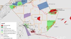
A gravity map compiled by TGS-Nopec demonstrates distinct NNE-SSW trending gravity anomalies. The anomalies are interpreted to reflect the presence of deep sedimentary basins separated by horst blocks. Quality seismic lines and onboard gravity support this interpretation.
A north-south trending seismic line (see accompanying figure) shows a very thick sedimentary succession with complex structures in the pre-Tertiary sediments. From regional interpretation, the uppermost four seconds of two-way-time (TWT) can probably be correlated with known Tertiary and uppermost Cretaceous successions drilled elsewhere in the region, whereas the age and lithology of the deeper parts (4.0-7.5 sec TWT) cannot be directly correlated to any known geology.
Petroleum Systems
The existence of older sedimentary successions in some of the basins in and along the Ungava Transform Fault Zone implies that there could be other petroleum systems present than those recorded elsewhere in the region.
Paleozoic source rocks like the Ordovician in western Newfoundland could be an interesting possibility, especially after the recent discovery of oil-stained Ordovician limestones from the 'Fossilik outlier' in the West Greenland basement. Furthermore, the regional nature of the Ungava Transform Fault Zone, as interpreted from gravity and magnetic data, connects the oil seep areas of the Nuussuaq region with the northernmost east Canadian discovery (Hejka: 2.3 Tcf + condensate).
This suggests that there may have been long periods in the Mesozoic when source rocks could have been deposited in a narrow and deep sea-way connecting the Atlantic and Arctic Oceans.
Recent work at Geological Survey of Denmark and Greenland (GEUS) has also suggested that Danian sediments of the same age as one of the known oil source rocks on Nuussuaq may be present and mature to the south and east of the Ungava Fault Zone.
Reservoirs are known from the Tertiary, and include Paleocene basin floor fans. The knowledge of pre-Tertiary reservoirs is scant, but a >100-meter-thick Santonian sandstone unit with 25% porosity was encountered in the lowermost part of the recently drilled Qulleq-1 well, suggesting that old horst complexes may have sourced sand for reservoirs in the adjacent basins.
The structural deformation of the area is dominantly pre-Eocene and Early Eocene with subsequent stable subsidence, favoring Tertiary maturation, migration, and trapping of hydrocarbons. There are several types of traps, with extensional normal fault-block traps being the most common. Compressional structures are seen along certain structural trends, and there are many possibilities for stratigraphic traps in fan systems of both Late Cretaceous and Tertiary age. - A prominent gravity high reflects the basement ridge west of Ikermiut Fault Zone. The fault zone itself is associated with NE-trending structures. The transition zone, north of SW2000, is indicated by a discontinuity in the anomaly pattern.
New seismic acquisition

Deep old sediments have long been recognized in the Sisimiut Basin, but their extension and internal features recognized on the 1999 and 2000 seismic data were considered so interesting that two new seismic surveys, amounting to approximately 4,000 km, were acquired in July and August 2001 in the Greenland-Canada border area (see map). The GreenCan2001 survey is a joint venture project between TGS-Nopec and the Greenland Bureau of Minerals and Petroleum (with GEUS as technical advisor). The survey was designed to:
- Study potential petroleum kitchens in the Lady Franklin Basin, an extensional basin south of the Ungava Transform Fault Zone
- Follow the deeper basins along the Ungava Transform Fault Zone a further 250 km northwards.
In addition, a tie-line connecting the three northernmost Canadian wells (Hekja 0-71, Raleigh N-18, Gjoa G-37) and the recent Greenland well (Qulleq-1) was acquired. Nonetheless, the amount of modern seismic data is still very limited - amounting to 35,000 km of 2D data over an area greater than that of the North Sea.
An additional survey (Green2001) by TGS-Nopec in the Greenland Open-Door area north of 68°N follows the trend of two deep basins stretching from the Ungava Transform Zone towards the northern oil seep areas in the Disko-Nuussuaq region. Interpretation of this area has previously been difficult, as standard acquisition has not penetrated the Paleogene volcanic succession sufficiently.
What's next?
New exploration opportunities in the vicinity of the deep basins may add additional possibilities to the forthcoming licensing round, and the possibility of additional targets has increased the interest of the petroleum industry. - Iceberg drift pattern in Davis Strait and Baffin Bay. The 2002 licensing round area off SW Greenland can be navigated year round. Only small icebergs drift with the West Greenland Current north in the Davis Strait. Iceberg sources lie north of the licensing area, and icebergs drift north or west in Baffin Bay and south along the Canadian coast.
The new Green2001 data may also increase interest in the northern Open-Door area. Additional seismic acquisition in 2002 is already being discussed among TGS-Nopec, the authorities, and the industry. New research is also being planned by GEUS and collaboration partners to map the old basins and to create better paleogeographic reconstructions.
West Greenland is one of the last major unexplored offshore areas close to a main market. Lack of good data combined with low oil prices has previously reduced interest in exploration investment.
Explorationists have hesitated to recommend investments because of anticipated problems with icebergs. It is, however, gradually becoming common knowledge that over most of the area, including in the licensing round, icebergs are both relatively small, compared to those seen in Canadian waters, and relatively rare, due to the pattern of sea currents along the West Greenland coast.
Greenland 2002 licensing round

Greenland has started the final preparations for a licensing round, which will be announced early in 2002. The round follows the exploration strategy, launched in the summer of 1999. One of the key points in the 1999 exploration strategy was to make it attractive for the seismic industry to acquire better seismic data and through new data to convince a broader part of the petroleum industry about the possible prospectivity of offshore West Greenland.
There have been three active seismic seasons offshore West Greenland - 1999, 2000, and 2001. These data highlight new exploration models, including deep old sedimentary successions. Furthermore, the data provide a much better visualization and understanding of the previously described Cretaceous and Paleogene plays that are known both offshore and from the oil seep area on Disko-Nuussuaq.
- Area: All of the unlicensed areas between 63°N and 68°N are available. This is comparable in size with the combined areas of the Central Graben, Viking Graben, and southern gas area in the North Sea.
- Time frame: The round is expected to open after final political approval in January 2002. The deadline for application is approximately three months later.
- Terms: Specific terms and economic parameters will be announced at formal opening meetings in Copenhagen and Houston, probably in January 2002. The present licenses and the model license for the Open-Door areas give some indication of the system.
Play types
- Source rocks: Paleocene deltaic mudstones and mid-Cretaceous marine anoxic mudstones are comparable to well-known oil seeps and source rocks from Nuussuaq and Ellesmere Island.
- Reservoirs: Reservoir rocks include Lower Cretaceous non-marine and shallow marine sandstones (known from Nuussuaq and off Labrador), Santonian marine sandstone (recently demonstrated in Qulleq-1), as well as Upper Cretaceous and Paleogene basin-floor and hanging-wall fan sandstones.
- Structures: Extensional fault blocks form features from Late Cretaceous-Paleocene rifting. Compressional features occur along strike-slip fault zones towards the west and were formed in the Eocene.
- Seals: Upper Cretaceous and Paleogene marine mudstones are seals.
Deep basin play types
- Source rocks: Ordovician (analogue to western Newfoundland, oil staining onshore West Greenland) and Jurassic (reworked palyno-morphs recorded in the Qulleq-1 well) rocks hold potential source material.
- Reservoir rocks: Paleozoic carbonates and Mesozoic sandstones are targets.
- Reservoirs: Cretaceous and Paleogene sand-stones are potential reservoirs.
- Structures: Tilted fault blocks, compress-ional features, and stratigraphic traps are alternate structural plays.
- Seals: Mesozoic, Cretaceous, and Paleogene marine mudstones are potential seals.
Physical environment
- Icebergs: These are limited in the area between 63° and 68°N. Higher concentrations occur towards the south and north, and in Canadian waters to the west.
- Sea ice: The entire licensing area is normally ice-free during the summer and autumn. Sea ice occurs commonly during winter and spring in the northwestern part of the licensing area, which is normally navigable all year round.
- Wind and temperature: Wind speeds are generally less than in the northern North Sea. Temperatures are lower both in summer and winter.
Licensing information is being handled by Hans Kristian Schønwandt, Bureau of Minerals and Petroleum (Nuuk: [email protected]) with seismic/ geological data inquiries going to Jens Christian Olsen at TGS-Nopec ([email protected]).